world.wikisort.org - France
Hures-la-Parade (French pronunciation: [yʁ la paʁad]; Occitan: Ura e la Parada) is a commune in the Lozère department in southern France.[3]
Hures-la-Parade | |
|---|---|
Commune | |
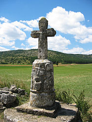
 The Croix du Buffre in Hures-la-Parade | |
Location of Hures-la-Parade  | |
 Hures-la-Parade  Hures-la-Parade | |
| Coordinates: 44°14′45″N 3°21′11″E | |
| Country | France |
| Region | Occitania |
| Department | Lozère |
| Arrondissement | Florac |
| Canton | Florac Trois Rivières |
| Intercommunality | CC Gorges Causses Cévennes |
| Government | |
| • Mayor (2021–2026) | Vincent Pratlong[1] |
| Area 1 | 88.59 km2 (34.20 sq mi) |
| Population | 231 |
| • Density | 2.6/km2 (6.8/sq mi) |
| Time zone | UTC+01:00 (CET) |
| • Summer (DST) | UTC+02:00 (CEST) |
| INSEE/Postal code | 48074 /48150 |
| Elevation | 501–1,204 m (1,644–3,950 ft) (avg. 1,000 m or 3,300 ft) |
| 1 French Land Register data, which excludes lakes, ponds, glaciers > 1 km2 (0.386 sq mi or 247 acres) and river estuaries. | |
Geography
Hures-la-Parade is situated on the Causse Méjean in the southeastern part of the Lozère department. It was created in 1971 after the fusion of the old communes of Hures and La Parade. With less than three inhabitants per square kilometer, it is one of the least densely populated French communes. The commune's southern border is delineated by the gorges of the Jonte river, which also form the border with the neighboring Aveyron department.
Nature
The territory of the commune houses three officially recognized natural sites:[4]
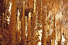
- The Aven Armand cave, located in the southern part of the commune and known for its large stalagmites.
- The Grotte Amélineau cave, unopened to the public.
- The gorges of the Jonte river
A group of Przewalski horses was released near the hamlet of Le Villaret in 2004 with the aim of preparing them for their eventual reintroduction in Western Mongolia.[5]

See also
- Communes of the Lozère department
- Causse Méjean
References
- "Répertoire national des élus: les maires" (in French). data.gouv.fr, Plateforme ouverte des données publiques françaises. 4 May 2022.
- "Populations légales 2019". The National Institute of Statistics and Economic Studies. 29 December 2021.
- INSEE commune file
- "Fichier national des sites classés" (PDF) (in French). Ministère de la transition écologique et solidaire. 29 December 2019. Retrieved 4 April 2021.
- "Our reintroduction project in Mongolia". Retrieved 4 April 2021.
На других языках
[de] Hures-la-Parade
Hures-la-Parade ist eine französische Gemeinde im Département Lozère in der Region Okzitanien. Sie gehört zum Kanton Florac Trois Rivières und zum Arrondissement Florac.- [en] Hures-la-Parade
Другой контент может иметь иную лицензию. Перед использованием материалов сайта WikiSort.org внимательно изучите правила лицензирования конкретных элементов наполнения сайта.
WikiSort.org - проект по пересортировке и дополнению контента Википедии