world.wikisort.org - France
Huahine is an island located among the Society Islands, in French Polynesia, an overseas territory of France in the Pacific Ocean. It is part of the Leeward Islands group (Îles sous le Vent). At the 2017 census it had a population of 6,075.[1]
Huahine | |
|---|---|
Commune | |
 NASA picture of Huahine viewed from the north | |
 Flag | |
 | |
Location of Huahine  | |
| Coordinates: 16°44′S 151°00′W | |
| Country | France |
| Overseas collectivity | French Polynesia |
| Subdivision | Leeward Islands |
| Government | |
| • Mayor (2020–2026) | Marcelin Lisan |
| Area 1 | 75 km2 (29 sq mi) |
| Population (2017) | 6,075 |
| • Density | 81/km2 (210/sq mi) |
| Time zone | UTC– 10:00 |
| INSEE/Postal code | 98724 /98731 |
| Elevation | 0–669 m (0–2,195 ft) |
| 1 French Land Register data, which excludes lakes, ponds, glaciers > 1 km2 (0.386 sq mi or 247 acres) and river estuaries. | |
History
Human presence on Huahine dates back to ancient times, as evidenced by the numerous marae on the island. Archaeologists estimate that the ancient Tahitian Ma'ohi people colonized Huahine from at least the 9th century AD.[2] Huahine is home to one of the largest concentrations of Polynesian archaeological remains dated between 850 AD and 1100 AD.
Independent kingdom
Until the late 19th century, Huahine was an independent kingdom, also called the Huahine and Maia'o Kingdom. According to tradition, three main dynasties succeeded each other:
The Hau-mo'o-rere dynasty was founded in the 17th century; its last representative was Queen Teha'apapa I, whom Captain Cook met in 1769. She maintained the cohesion and independence of her kingdom.
The Tamatoa dynasty has its origin in Teha'apapa I and her husband Mato a Tamatoa, member of the Tamatoa family of Raiatea. They are the founders of the Tamatoa branch of Huahine. This dynasty reigned until 1854.
The Teurura'i dynasty descends from Ari'imate Teurura'i, a Huahine chief, and his wife Teri'iteporouara'i Tamatoa, member of the Tamatoa family of Raiatea, great-granddaughter of Queen Teha'apapa I of Huahine. This dynasty reigned from 1854 to 1895.
Teriifa'atau Marama Polynesian prince, could claim the thrones of Huahine and Raiatea at the same time. However, the union of these two thrones under one scepter could not be contemplated, so it was agreed that his younger brother would inherit the throne of Raiatea.
In 1884, he obtained the position of prime minister of the Kingdom, a post previously held by his younger brother, who became King of Raiatea in 1884.
He became the protagonist of the annexation of the kingdom of Huahine and Maia'o to France. It was in 1895 that the regent, on behalf of Queen Tehaapapa, and the principal chiefs of the kingdom fully renounced their powers and attributions in favor of France in a treaty of abdication dated 15 September of the same year.
After the annexation, he was elected chief of Tefareri'i, a position he held until his death.
European exploration and colonization
The name Huahine literally means "woman's sex". It could probably be translated as "pregnant woman" since the profile of Mount Tavaiura makes one think of a pregnant woman lying down.

Captain James Cook arrived in Fare Harbour on 16 July 1769, with Tupaia navigating HMS Endeavour. They met with leading chief Ori (Mato). Cook returned on 3 September 1773 and met with Ori's son Teri'itaria, the new ari'i rahi of the island.[3]
Missionary Auna served as a deacon on Huahine prior to his work in Hawaii.[4]
The Spaniard Domingo Bonaechea in 1775, called the island "La Hermosa" (The Beautiful).[5][6] Today it is known by the nickname "the island of the woman".
In 1846 the island successfully resisted French rule,[7] the inhabitants never resigned themselves to the idea of being colonized and in 1847 the island proclaimed itself an independent state under the name of the Kingdom of Huahine.
On 20 April 1879, the commander of the SMS Bismarck, Karl Deinhard, and the German Empire's consul for the South Sea Islands, Gustav Godeffroy Junior, signed a treaty of friendship and commerce with the island's government on behalf of the German Empire.[8]
In 1888 the French finally established a protectorate over the Island.[9] The hitherto independent kingdom of Huahine and Maia'o was not annexed until 1895 (deposing the last queen Te-ha'apapa III) and incorporated into the French Establishments of Oceania, now French Polynesia, which had existed since 1898.
Geography
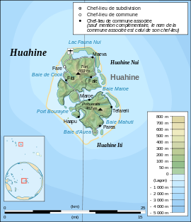
Huahine measures 16 km (10 mi) in length, with a maximum width of 13 km (8 mi). It is made up of two main islands surrounded by a fringing coral reef with several islets, or motu. Huahine Nui (Big Huahine) lies to the north and Huahine Iti (Little Huahine) to the south. The total land area is 75 km2.[10] The two islands are separated by a few hundred metres of water and joined by a sandspit at low tide. A small bridge was built to connect Huahine Nui and Huahine Iti. Its highest point is Turi, at 669 m elevation.
In the northwest of Huahine Nui lies a 375 hectares (926.65 acres) brackish lake known as Lac Fauna Nui (Lac Maeva). This lake is all that remains of the ancient atoll lagoon. Air transportation is available via Huahine airport, located on the northern shore of Huahine Nui.
Flora and fauna

The island is covered with lush vegetation, much of which consists of coconut palms. There are also two important botanical gardens: the Ariiura Garden Paradise, which houses traditional Polynesian medicinal plants, and l'Eden Parc, where fruit trees from the rest of the world are cultivated.[11]
The fauna is especially rich in fish and birds. Among the latter is a species that became extinct centuries ago, the Huahine starling (Aplonis diluvialis), whose fossils found on the island date its disappearance some seven centuries ago (although the German naturalist Georg Forster depicted in the 18th century a bird on the island of Raiatea very similar to the animal in question).
Administration

Administratively Huahine is a commune (municipality) part of the administrative subdivision of the Leeward Islands.[12] Huahine consists of the following associated communes:[13]
- Faie
- Fare
- Fitii
- Haapu
- Maeva
- Maroe
- Parea
- Tefarerii
The administrative centre of the commune is the settlement of Fare,[13] on Huahine Nui.
Demographics
The total population was 5,999 inhabitants in the 2007 census,16 which increased to 6075 inhabitants in 2017, distributed in eight Villages: Fare (the capital), Maeva, Faie, Fiti'i, Parea, Tefareri'i, Ha'apu and Maroe.
The main activities are vanilla cultivation, copra production, fishing and tourism.

Sport
In terms of sports, Huahine is, along with neighboring Bora Bora, Tahaa and Raiatea, one of the four islands among which the Hawaiki Nui Va'a, an international Polynesian canoe (va'a) competition, is held.
Religion
Most of the population follows Christianity as a result of the activity of missionaries from both the Catholic Church and various Protestant groups, and European colonization.
In 1809 the island had its first contact with Protestant Christian missionaries.[9] In 1815 the Protestant mission ordered the destruction of the idols of the ancient gods of the local religion.[9] In the following decades, Catholic missionaries arrived. Between 1819 and 1820 the first chapel was built on the island.[14]
Catholics, under the direction of the Archdiocese of Papeete, administer 1 religious building, the Church of the Holy Family (Église de la Sainte-Famille)[15] which was reopened in the town of Fare[15] (northwest of the island) on 30 October 2010.[15] The original church had been established however between 1906 and 1909.[16]
Economy

The inhabitants of the island are engaged in activities such as agriculture and fishing. Agricultural products include vanilla (vanilla tahitiensis species) and various types of melons. Thanks to the lush coconut forest, copra production is also a very important activity for the local economy.
Tourism
Tourism through cruise ship passengers calling at the atoll and the airport is another important economic sector.
One of the famous attractions on Huahine is a bridge that crosses over a stream with 0.9 m – 1.8 m long freshwater eels. These eels are deemed sacred by the locals, by local mythology. While viewing these slithering creatures, tourists can buy a can of mackerel and feed the eels. The Fa'ahia archaeological site in the north of the island has revealed subfossil remains of several species of extinct birds exterminated by the earliest Polynesian colonists of the island.
Transportation
The island has scheduled passenger airline flights operated by Air Tahiti with ATR turboprop aircraft via the Huahine - Fare Airport.
See also
| Wikimedia Commons has media related to Huahine. |
- Dependent Territory
- List of monarchs of Huahine
References
- Répartition de la population en Polynésie française en 2017, Institut de la statistique de la Polynésie française
- "Huahine Island. Pacific Blue Adventure Diving Center. Diving Paradise". 10 July 2011. Archived from the original on 10 July 2011. Retrieved 26 August 2021.
- Salmond, Anne (2010). Aphrodite's Island. Berkeley: University of California Press. pp. 205–209, 281, 314–318. ISBN 9780520261143.
- Garrett, John (1999). "Auna". In Gerald H. Anderson (ed.). Biographical Dictionary of Christian Missions. Wm. B. Eerdmans Publishing. ISBN 978-0-8028-4680-8.
- Rózpide, Ricardo Beltrán y (1884). La Polinesia: descubrimiento, reseña y descripción geográficas, clima, constitución geológica, producción y población de las islas situadas en la región oriental del mar Pacífico; raza, idioma, historia, religión, gobierno, costumbres, cultura intelectual, industria y comercio ... principales viajes efectuados en aquella parte de la Oceanía por navegantes españoles y extranjeros ... importancia y porvenir comercial y político ... documentos inéditos relativos á su descubrimiento y un mapa general ... (in Spanish). Fortanet.
- Corney, Bolton Glanvill (15 May 2017). The Quest and Occupation of Tahiti by Emissaries of Spain during the Years 1772–1776: Told in Despatches and other Contemporary Documents. Volumes I-III. Routledge. ISBN 978-1-317-01845-2.
- Carter, Former Senior Lecturer John; Carter, John (1981). Pacific Islands Yearbook, 1981. Pacific Publications Pty, Limited. ISBN 978-0-85807-049-3.
- Overlack, Peter (2001). "Review of Die deutsche Sudsee 1884–1914. Ein Handbuch". The Journal of Military History. 65 (3): 809–810. doi:10.2307/2677564. ISSN 0899-3718. JSTOR 2677564.
- HUAHINE Par Jean Francois BARE. Nouvelles Editions Latines.
- Communes of French Polynesia, statoids.com
- "huahine". 8 May 2006. Archived from the original on 8 May 2006. Retrieved 27 August 2021.
- Décret n° 2005-1611 du 20 décembre 2005 pris pour l'application du statut d'autonomie de la Polynésie française, Légifrance
- Décret n°72-407 du 17 mai 1972 portant création de communes dans le territoire de la Polynésie française, Légifrance
- BOOK, MISSIONARY GUIDE (1846). The Missionary Guide-Book; Or a Key to the Protestant Missionary Map of the World; Shewing the Geography, Natural History, Climate, Population and Government; Also the Rise and Progress of Missionary Operations in Each Country. Seeley & Company.
- "Église de la Sainte-Famille". GCatholic. Retrieved 27 August 2021.
- "HUAHINE STE FAMILLE". www.diocesedepapeete.com. Retrieved 27 August 2021.
External links
- Tahiti Tourism Board website
- Tourism portal on Huahine
- Free travel guide – Bilingual french english – 2016–2017
Society Islands of French Polynesia | |||
|---|---|---|---|
| |||
| |||
| Authority control |
|
|---|
На других языках
[de] Huahine
Huahine ist eine Insel im Pazifischen Ozean und gehört zu den Gesellschaftsinseln, einem der fünf Archipele Französisch-Polynesiens. Innerhalb des Archipels stellt es das östlichste Atoll der Gruppe der Inseln unter dem Winde (französisch Îles-sous-le-Vent, tahitianisch Raromatai) dar.- [en] Huahine
[es] Huahine (isla)
Huahine[1][2] es una de las islas de Sotavento[3] del archipiélago de las islas de la Sociedad,[4][5] en la Polinesia Francesa.[6][7] Es la isla más oriental del grupo, situada a 175 km al oeste de la isla de Tahití.[fr] Huahine
Huahine, prononcé [Houahiné avec deux «h» expirés comme le «h» de help (angl.)], ou « l'Authentique » est une île de Polynésie française qui fait partie des îles Sous-le-Vent, dans l'archipel de la Société. Elle est située à 34 km à l'est-nord-est de Raiatea, à 43 km à l'est-sud-est de Taha'a et à 167 km à l'ouest-nord-ouest de Tahiti, par 151° de longitude Ouest et 16°30 de latitude Sud. Elle est aussi proche de Bora-Bora.[it] Huahine
Huahine (che in lingua tahitiana significa letteralmente "vagina", da "hua", vagina o sesso, e "hine", donne, nome attribuitogli dai nativi per la forma, che ricorderebbe quella dell'organo sessuale femminile[1]; in passato l'isola era nota come Matairea) è un'isola facente parte dell'arcipelago delle Isole della Società, precisamente nel gruppo delle Isole Sottovento, nell'Oceano Pacifico. Amministrativamente è ricompresa nella Collettività d'Oltremare della Polinesia francese e costituisce l'omonimo comune (capoluogo Fare) del dipartimento d'Oltremare delle Isole Sottovento.[ru] Хуахине
Хуахине (фр. Huahine) — один из Подветренных островов в составе Островов Общества, принадлежит Французской Полинезии, заморской территории Франции. Представляет собой двойной вулканический остров, окружённый рифом размером 15 X 10 километров[1].Другой контент может иметь иную лицензию. Перед использованием материалов сайта WikiSort.org внимательно изучите правила лицензирования конкретных элементов наполнения сайта.
WikiSort.org - проект по пересортировке и дополнению контента Википедии