world.wikisort.org - France
Hastingues (French pronunciation: [astɛ̃ɡ]; Occitan: Hastings, Basque: Hastinga) is a commune in the Landes department in Nouvelle-Aquitaine in southwestern France.[2] Its nickname, due to its location on a rounded-shaped hill, is Lou Carcolh (the snail).
Hastingues | |
|---|---|
Commune | |
 Gate of Hastingues from the 14th century | |
Location of Hastingues  | |
 Hastingues  Hastingues | |
| Coordinates: 43°32′07″N 1°08′52″W | |
| Country | France |
| Region | Nouvelle-Aquitaine |
| Department | Landes |
| Arrondissement | Dax |
| Canton | Orthe et Arrigans |
| Intercommunality | Pays d'Orthe et Arrigans |
| Government | |
| • Mayor (2020–2026) | Corine de Passos |
| Area 1 | 14.54 km2 (5.61 sq mi) |
| Population | 592 |
| • Density | 41/km2 (110/sq mi) |
| Time zone | UTC+01:00 (CET) |
| • Summer (DST) | UTC+02:00 (CEST) |
| INSEE/Postal code | 40120 /40300 |
| Elevation | 0–84 m (0–276 ft) (avg. 44 m or 144 ft) |
| 1 French Land Register data, which excludes lakes, ponds, glaciers > 1 km2 (0.386 sq mi or 247 acres) and river estuaries. | |
Geography
The town lies on a hill looking over the valley of the Gaves réunis, in the Gascon region and bordering on the Basque Country.
History
The bastide was founded in 1289 by John Hastings, seneschal of Gascony, who signed a treaty of coregency in the name of Edward I of England between the king, Duke of Aquitaine and the monks of Arthous abbey.
The work on the gate was started in 1289, but the town wall still was not complete in the 15th century.
The houses of Jurats and Sénéchal were built in the same century.
Population
|
|
 View from the town over the valley and the river
 Maison Jurats
 House of the Seneschal
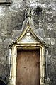 Entrance of the house of the Seneschal
 Detail of the gate


References
- "Populations légales 2019". The National Institute of Statistics and Economic Studies. 29 December 2021.
- INSEE commune file
See also
Authority control | |
|---|---|
| General |
|
| National libraries | |
This Landes geographical article is a stub. You can help Wikipedia by expanding it. |
На других языках
[de] Hastingues
Hastingues ist eine französische Gemeinde mit 592 Einwohnern (Stand 1. Januar 2019) im Département Landes in der Region Nouvelle-Aquitaine (vor 2016 Aquitaine) im Südwesten Frankreichs. Sie gehört zum Arrondissement Dax und zum Kanton Orthe et Arrigans. Die Einwohner werden Hastingots genannt.- [en] Hastingues
[fr] Hastingues
Hastingues est une commune française, située dans le département des Landes en région Nouvelle-Aquitaine.Другой контент может иметь иную лицензию. Перед использованием материалов сайта WikiSort.org внимательно изучите правила лицензирования конкретных элементов наполнения сайта.
WikiSort.org - проект по пересортировке и дополнению контента Википедии