world.wikisort.org - France
Corent is a commune in the Puy-de-Dôme department in Auvergne-Rhône-Alpes in central France.
Corent | |
|---|---|
Commune | |
 View from the Corent plateau | |
 Coat of arms | |
Location of Corent  | |
 Corent  Corent | |
| Coordinates: 45°40′05″N 3°11′43″E | |
| Country | France |
| Region | Auvergne-Rhône-Alpes |
| Department | Puy-de-Dôme |
| Arrondissement | Clermont-Ferrand |
| Canton | Les Martres-de-Veyre[1] |
| Government | |
| • Mayor (2020–2026) | Thierry Julien[2] |
| Area 1 | 2.68 km2 (1.03 sq mi) |
| Population | 762 |
| • Density | 280/km2 (740/sq mi) |
| Time zone | UTC+01:00 (CET) |
| • Summer (DST) | UTC+02:00 (CEST) |
| INSEE/Postal code | 63120 /63730 |
| Elevation | 330–610 m (1,080–2,000 ft) (avg. 500 m or 1,600 ft) |
| 1 French Land Register data, which excludes lakes, ponds, glaciers > 1 km2 (0.386 sq mi or 247 acres) and river estuaries. | |
It sits approximately 2 miles north of Les Martres-de-Veyre on the side of the old volcanic Puy de Corent.
In 2001 excavation began on a Gallic (Celtic) and later Gallo-Roman Oppidum found in a field atop the puy. To this date, vast quantities of land have been excavated revealing the site as a main political, religious and economic center.[4] Corent was an important fortified Celtic oppidum during the pre-Roman La Tène period (Late Iron Age), and there was already a fortified settlement on the plateau during the Urnfield period (Late Bronze Age).
Gallic oppidum
 Corent sanctuary
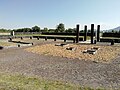 Sanctuary
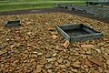 Sanctuary - libation pit
 Excavations


See also
References
- "Décret 2014-210 du 21 février 2014 portant délimitation des cantons dans le département du Puy-de-Dôme" [2014-210 decree delimiting cantons of Puy-de-Dôme department]. Légifrance (in French). 21 February 2014.
- "Répertoire national des élus: les maires" (in French). data.gouv.fr, Plateforme ouverte des données publiques françaises. 13 September 2022.
- "Populations légales 2019". The National Institute of Statistics and Economic Studies. 29 December 2021.
- Fouilles de Corent
Wikimedia Commons has media related to Corent.
Authority control | |
|---|---|
| General |
|
| National libraries | |
This Puy-de-Dôme geographical article is a stub. You can help Wikipedia by expanding it. |
На других языках
[de] Corent
Corent ist eine französische Gemeinde mit 762 Einwohnern (Stand 1. Januar 2019) im Département Puy-de-Dôme in der Region Auvergne-Rhône-Alpes. Sie liegt etwa 20 Kilometer südlich von Clermont-Ferrand.- [en] Corent
Текст в блоке "Читать" взят с сайта "Википедия" и доступен по лицензии Creative Commons Attribution-ShareAlike; в отдельных случаях могут действовать дополнительные условия.
Другой контент может иметь иную лицензию. Перед использованием материалов сайта WikiSort.org внимательно изучите правила лицензирования конкретных элементов наполнения сайта.
Другой контент может иметь иную лицензию. Перед использованием материалов сайта WikiSort.org внимательно изучите правила лицензирования конкретных элементов наполнения сайта.
2019-2026
WikiSort.org - проект по пересортировке и дополнению контента Википедии
WikiSort.org - проект по пересортировке и дополнению контента Википедии