world.wikisort.org - France
Aurec-sur-Loire (French pronunciation: [oʁɛk syʁ lwaʁ], literally Aurec on Loire; Occitan: Aurec) is a commune in the Haute-Loire department in south-central France.
Aurec-sur-Loire | |
|---|---|
Commune | |
 | |
 Coat of arms | |
Location of Aurec-sur-Loire  | |
 Aurec-sur-Loire  Aurec-sur-Loire | |
| Coordinates: 45°22′12″N 4°12′09″E | |
| Country | France |
| Region | Auvergne-Rhône-Alpes |
| Department | Haute-Loire |
| Arrondissement | Yssingeaux |
| Canton | Aurec-sur-Loire |
| Intercommunality | Loire et Semène |
| Government | |
| • Mayor (2020–2026) | Claude Vial[1] |
| Area 1 | 22.44 km2 (8.66 sq mi) |
| Population | 6,142 |
| • Density | 270/km2 (710/sq mi) |
| Time zone | UTC+01:00 (CET) |
| • Summer (DST) | UTC+02:00 (CEST) |
| INSEE/Postal code | 43012 /43110 |
| Elevation | 414–821 m (1,358–2,694 ft) (avg. 432 m or 1,417 ft) |
| 1 French Land Register data, which excludes lakes, ponds, glaciers > 1 km2 (0.386 sq mi or 247 acres) and river estuaries. | |
Population
|
| ||||||||||||||||||||||||||||||||||||||||||||||||||||||||||||||||||||||||||||||||||||||||||||||||||||||||||||||||||
| Source: EHESS[3] and INSEE (1968-2017)[4] | |||||||||||||||||||||||||||||||||||||||||||||||||||||||||||||||||||||||||||||||||||||||||||||||||||||||||||||||||||
Galleries
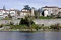 Ramparts.
 Former doorway to the Castle.
 North face
 Tower of the Burgundians.
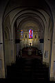 Nave.
Nave.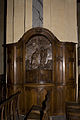 Baptismal Fonts
 Altar and altarpiece.
 Pieta.
 St. Peter.
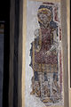 St. Michael.


See also
References
- "Répertoire national des élus: les maires". data.gouv.fr, Plateforme ouverte des données publiques françaises (in French). 2 December 2020.
- "Populations légales 2019". The National Institute of Statistics and Economic Studies. 29 December 2021.
- Des villages de Cassini aux communes d'aujourd'hui: Commune data sheet Aurec-sur-Loire, EHESS. (in French)
- Population en historique depuis 1968, INSEE
Wikimedia Commons has media related to Aurec-sur-Loire.
Authority control | |
|---|---|
| General |
|
| National libraries | |
This Haute-Loire geographical article is a stub. You can help Wikipedia by expanding it. |
На других языках
[de] Aurec-sur-Loire
Aurec-sur-Loire ist eine französische Gemeinde mit 6142 Einwohnern (Stand: 1. Januar 2019) im Département Haute-Loire in der Region Auvergne-Rhône-Alpes. Sie gehört zum Arrondissement Yssingeaux und ist der Hauptort (frz.: chef-lieu) des Kantons Aurec-sur-Loire.- [en] Aurec-sur-Loire
Текст в блоке "Читать" взят с сайта "Википедия" и доступен по лицензии Creative Commons Attribution-ShareAlike; в отдельных случаях могут действовать дополнительные условия.
Другой контент может иметь иную лицензию. Перед использованием материалов сайта WikiSort.org внимательно изучите правила лицензирования конкретных элементов наполнения сайта.
Другой контент может иметь иную лицензию. Перед использованием материалов сайта WikiSort.org внимательно изучите правила лицензирования конкретных элементов наполнения сайта.
2019-2026
WikiSort.org - проект по пересортировке и дополнению контента Википедии
WikiSort.org - проект по пересортировке и дополнению контента Википедии