world.wikisort.org - France
The arrondissement of Saint-Flour is an arrondissement of France in the Cantal department in the Auvergne-Rhône-Alpes region. It has 98 communes.[2] Its population is 37,697 (2016), and its area is 2,510.6 km2 (969.3 sq mi).[3]
Saint-Flour | |
|---|---|
Arrondissement | |
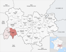 Location within the region Auvergne-Rhône-Alpes | |
| Country | France |
| Region | Auvergne-Rhône-Alpes |
| Department | Cantal |
| No. of communes | 98 |
| Subprefecture | Saint-Flour |
| Area | 2,510.6 km2 (969.3 sq mi) |
| Population | 37,396 |
| • Density | 15/km2 (40/sq mi) |
| INSEE code | 153 |
Composition
The communes of the arrondissement of Saint-Flour, and their INSEE codes, are:[2]
- Albepierre-Bredons (15025)
- Allanche (15001)
- Alleuze (15002)
- Andelat (15004)
- Anglards-de-Saint-Flour (15005)
- Anterrieux (15007)
- Auriac-l'Église (15013)
- Bonnac (15022)
- Brezons (15026)
- Celoux (15032)
- Cézens (15033)
- Chaliers (15034)
- Chanterelle (15040)
- La Chapelle-d'Alagnon (15041)
- La Chapelle-Laurent (15042)
- Charmensac (15043)
- Chaudes-Aigues (15045)
- Chazelles (15048)
- Cheylade (15049)
- Le Claux (15050)
- Clavières (15051)
- Coltines (15053)
- Condat (15054)
- Coren (15055)
- Cussac (15059)
- Deux-Verges (15060)
- Dienne (15061)
- Espinasse (15065)
- Ferrières-Saint-Mary (15069)
- Fridefont (15073)
- Gourdièges (15077)
- Jabrun (15078)
- Joursac (15080)
- Lacapelle-Barrès (15086)
- Landeyrat (15091)
- Lastic (15097)
- Laurie (15098)
- Laveissenet (15100)
- Laveissière (15101)
- Lavigerie (15102)
- Leyvaux (15105)
- Lieutadès (15106)
- Lorcières (15107)
- Lugarde (15110)
- Malbo (15112)
- Marcenat (15114)
- Marchastel (15116)
- Massiac (15119)
- Maurines (15121)
- Mentières (15125)
- Molèdes (15126)
- Molompize (15127)
- Montboudif (15129)
- Montchamp (15130)
- Montgreleix (15132)
- Murat (15138)
- Narnhac (15139)
- Neussargues en Pinatelle (15141)
- Neuvéglise-sur-Truyère (15142)
- Paulhac (15148)
- Paulhenc (15149)
- Peyrusse (15151)
- Pierrefort (15152)
- Pradiers (15155)
- Rageade (15158)
- Rézentières (15161)
- Roffiac (15164)
- Ruynes-en-Margeride (15168)
- Saint-Amandin (15170)
- Saint-Bonnet-de-Condat (15173)
- Sainte-Marie (15198)
- Saint-Flour (15187)
- Saint-Georges (15188)
- Saint-Martial (15199)
- Saint-Martin-sous-Vigouroux (15201)
- Saint-Mary-le-Plain (15203)
- Saint-Poncy (15207)
- Saint-Rémy-de-Chaudes-Aigues (15209)
- Saint-Saturnin (15213)
- Saint-Urcize (15216)
- Ségur-les-Villas (15225)
- Soulages (15229)
- Talizat (15231)
- Tanavelle (15232)
- Les Ternes (15235)
- Tiviers (15237)
- La Trinitat (15241)
- Ussel (15244)
- Vabres (15245)
- Val-d'Arcomie (15108)
- Valjouze (15247)
- Valuéjols (15248)
- Védrines-Saint-Loup (15251)
- Vernols (15253)
- Vèze (15256)
- Vieillespesse (15259)
- Villedieu (15262)
- Virargues (15263)
History
The arrondissement of Saint-Flour was created in 1800.[4]
As a result of the reorganisation of the cantons of France which came into effect in 2015, the borders of the cantons are no longer related to the borders of the arrondissements. The cantons of the arrondissement of Saint-Flour were, as of January 2015:[5]
- Allanche
- Chaudes-Aigues
- Condat
- Massiac
- Murat
- Pierrefort
- Ruynes-en-Margeride
- Saint-Flour-Nord
- Saint-Flour-Sud
References
- "Téléchargement du fichier d'ensemble des populations légales en 2019". The National Institute of Statistics and Economic Studies. 29 December 2021.
- "Arrondissement de Saint-Flour (153)". INSEE. Retrieved 2019-09-27.
- "Comparateur de territoire, géographie au 01/01/2019". INSEE. Retrieved 2019-09-27.
- Historique du Cantal
- "Populations légales 2012: 15 Cantal" (PDF). INSEE. December 2014.
|
На других языках
[de] Arrondissement Saint-Flour
Das Arrondissement Saint-Flour ist ein Verwaltungsbezirk im Département Cantal in der französischen Region Auvergne-Rhône-Alpes. Hauptort (Unterpräfektur) ist Saint-Flour.- [en] Arrondissement of Saint-Flour
[ru] Сен-Флур (округ)
Сен-Флур (фр. Saint-Flour) — округ (фр. Arrondissement) во Франции, один из округов в регионе Овернь. Департамент округа — Канталь. Супрефектура — Сен-Флур. Население округа на 2006 год составляло 39 225 человек. Плотность населения составляет 16 чел./км². Площадь округа составляет всего 2511 км².Текст в блоке "Читать" взят с сайта "Википедия" и доступен по лицензии Creative Commons Attribution-ShareAlike; в отдельных случаях могут действовать дополнительные условия.
Другой контент может иметь иную лицензию. Перед использованием материалов сайта WikiSort.org внимательно изучите правила лицензирования конкретных элементов наполнения сайта.
Другой контент может иметь иную лицензию. Перед использованием материалов сайта WikiSort.org внимательно изучите правила лицензирования конкретных элементов наполнения сайта.
2019-2025
WikiSort.org - проект по пересортировке и дополнению контента Википедии
WikiSort.org - проект по пересортировке и дополнению контента Википедии