world.wikisort.org - France
The arrondissement of Nanterre is an arrondissement of France in the Hauts-de-Seine department in the Île-de-France region. It has 17 communes.[2] Its population is 888,181 (2016), and its area is 91.8 km2 (35.4 sq mi).[3]
Nanterre | |
|---|---|
Arrondissement | |
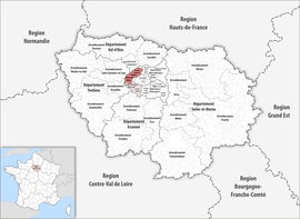 Location within the region Île-de-France | |
| Country | France |
| Region | Île-de-France |
| Department | Hauts-de-Seine |
| No. of communes | 17 |
| Prefecture | Nanterre |
| Area | 91.8 km2 (35.4 sq mi) |
| Population | 900,667 |
| • Density | 9,811/km2 (25,410/sq mi) |
| INSEE code | 922 |
Composition
The communes of the arrondissement of Nanterre, and their INSEE codes, are:[2]
- Asnières-sur-Seine (92004)
- Bois-Colombes (92009)
- Clichy (92024)
- Colombes (92025)
- Courbevoie (92026)
- Garches (92033)
- La Garenne-Colombes (92035)
- Gennevilliers (92036)
- Levallois-Perret (92044)
- Nanterre (92050)
- Neuilly-sur-Seine (92051)
- Puteaux (92062)
- Rueil-Malmaison (92063)
- Saint-Cloud (92064)
- Suresnes (92073)
- Vaucresson (92076)
- Villeneuve-la-Garenne (92078)
History
The arrondissement of Nanterre was created in 1964 as part of the department Seine. In 1968 it became part of the new department Hauts-de-Seine.[4] At the January 2017 reorganisation of the arrondissements of Hauts-de-Seine, it received two communes from the arrondissement of Boulogne-Billancourt.[5]
As a result of the reorganisation of the cantons of France which came into effect in 2015, the borders of the cantons are no longer related to the borders of the arrondissements. The cantons of the arrondissement of Nanterre were, as of January 2015:[6]
- Asnières-sur-Seine-Nord
- Asnières-sur-Seine-Sud
- Bois-Colombes
- Clichy
- Colombes-Nord-Est
- Colombes-Nord-Ouest
- Colombes-Sud
- Courbevoie-Nord
- Courbevoie-Sud
- Garches
- La Garenne-Colombes
- Gennevilliers-Nord
- Gennevilliers-Sud
- Levallois-Perret-Nord
- Levallois-Perret-Sud
- Nanterre-Nord
- Nanterre-Sud-Est
- Nanterre-Sud-Ouest
- Neuilly-sur-Seine-Nord
- Neuilly-sur-Seine-Sud
- Puteaux
- Rueil-Malmaison
- Suresnes
- Villeneuve-la-Garenne
References
- "Téléchargement du fichier d'ensemble des populations légales en 2019". The National Institute of Statistics and Economic Studies. 28 December 2020.
- "Arrondissement de Nanterre (922)". INSEE. Retrieved 2019-10-05.
- "Comparateur de territoire, géographie au 01/01/2019". INSEE. Retrieved 2019-10-05.
- Historique des Hauts-de-Seine
- "Arrêté préfectoral, 30 December 2016" (PDF). pp. 29–31. Retrieved 2019-10-28.
- "Populations légales 2012: 92 Hauts-de-Seine" (PDF). INSEE. December 2014.
|
| Authority control |
|
|---|
На других языках
- [en] Arrondissement of Nanterre
[ru] Нантер (округ)
Нанте́р (фр. Nanterre) — округ (фр. Arrondissement) во Франции, один из округов в регионе Иль-де-Франс (регион). Департамент округа — О-де-Сен. Супрефектура — Нантер. Население округа на 2006 год составляло 823 566 человек. Плотность населения составляет 10167 чел./км². Площадь округа составляет всего 81 км².Другой контент может иметь иную лицензию. Перед использованием материалов сайта WikiSort.org внимательно изучите правила лицензирования конкретных элементов наполнения сайта.
WikiSort.org - проект по пересортировке и дополнению контента Википедии