world.wikisort.org - France
The arrondissement of Dreux is an arrondissement of France in the Eure-et-Loir department in the Centre-Val de Loire region. It has 108 communes.[2] Its population is 129,414 (2016), and its area is 1,500.5 km2 (579.3 sq mi).[3]
Dreux | |
|---|---|
Arrondissement | |
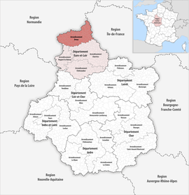 Location within the region Centre-Val de Loire | |
| Country | France |
| Region | Centre-Val de Loire |
| Department | Eure-et-Loir |
| No. of communes | 108 |
| Subprefecture | Dreux |
| Area | 1,500.5 km2 (579.3 sq mi) |
| Population | 128,825 |
| • Density | 86/km2 (220/sq mi) |
| INSEE code | 283 |
Composition
The communes of the arrondissement of Dreux, and their INSEE codes, are:[2]
- Abondant (28001)
- Allainville (28003)
- Anet (28007)
- Ardelles (28008)
- Aunay-sous-Crécy (28014)
- Beauche (28030)
- Berchères-sur-Vesgre (28036)
- Bérou-la-Mulotière (28037)
- Boissy-en-Drouais (28045)
- Boissy-lès-Perche (28046)
- Boncourt (28050)
- Le Boullay-les-Deux-Églises (28053)
- Le Boullay-Mivoye (28054)
- Le Boullay-Thierry (28055)
- Boutigny-Prouais (28056)
- Bréchamps (28058)
- Brezolles (28059)
- Broué (28062)
- Bû (28064)
- La Chapelle-Forainvilliers (28076)
- La Chapelle-Fortin (28077)
- Charpont (28082)
- Châtaincourt (28087)
- Châteauneuf-en-Thymerais (28089)
- Les Châtelets (28090)
- Chaudon (28094)
- La Chaussée-d'Ivry (28096)
- Cherisy (28098)
- Coulombs (28113)
- Crécy-Couvé (28117)
- Croisilles (28118)
- Crucey-Villages (28120)
- Dampierre-sur-Avre (28124)
- Digny (28130)
- Dreux (28134)
- Écluzelles (28136)
- Escorpain (28143)
- Faverolles (28146)
- Favières (28147)
- La Ferté-Vidame (28149)
- Fessanvilliers-Mattanvilliers (28151)
- Fontaine-les-Ribouts (28155)
- La Framboisière (28159)
- Garancières-en-Drouais (28170)
- Garnay (28171)
- Germainville (28178)
- Gilles (28180)
- Goussainville (28185)
- Guainville (28187)
- Havelu (28193)
- Jaudrais (28200)
- Lamblore (28202)
- Laons (28206)
- Lormaye (28213)
- Louvilliers-en-Drouais (28216)
- Louvilliers-lès-Perche (28217)
- Luray (28223)
- Maillebois (28226)
- La Mancelière (28231)
- Marchezais (28235)
- Marville-Moutiers-Brûlé (28239)
- Le Mesnil-Simon (28247)
- Le Mesnil-Thomas (28248)
- Mézières-en-Drouais (28251)
- Montigny-sur-Avre (28263)
- Montreuil (28267)
- Morvilliers (28271)
- Néron (28275)
- Nogent-le-Roi (28279)
- Ormoy (28289)
- Ouerre (28292)
- Oulins (28293)
- Les Pinthières (28299)
- Prudemanche (28308)
- La Puisaye (28310)
- Puiseux (28312)
- Les Ressuintes (28314)
- Revercourt (28315)
- Rohaire (28316)
- Rouvres (28321)
- Rueil-la-Gadelière (28322)
- Saint-Ange-et-Torçay (28323)
- Sainte-Gemme-Moronval (28332)
- Saint-Jean-de-Rebervilliers (28341)
- Saint-Laurent-la-Gâtine (28343)
- Saint-Lubin-de-Cravant (28346)
- Saint-Lubin-de-la-Haye (28347)
- Saint-Lubin-des-Joncherets (28348)
- Saint-Lucien (28349)
- Saint-Maixme-Hauterive (28351)
- Saint-Ouen-Marchefroy (28355)
- Saint-Rémy-sur-Avre (28359)
- Saint-Sauveur-Marville (28360)
- La Saucelle (28368)
- Saulnières (28369)
- Saussay (28371)
- Senantes (28372)
- Senonches (28373)
- Serazereux (28374)
- Serville (28375)
- Sorel-Moussel (28377)
- Thimert-Gâtelles (28386)
- Tremblay-les-Villages (28393)
- Tréon (28394)
- Vernouillet (28404)
- Vert-en-Drouais (28405)
- Villemeux-sur-Eure (28415)
- Villiers-le-Morhier (28417)
History
The arrondissement of Dreux was created in 1800.[4]
As a result of the reorganisation of the cantons of France which came into effect in 2015, the borders of the cantons are no longer related to the borders of the arrondissements. The cantons of the arrondissement of Dreux were, as of January 2015:[5]
- Anet
- Brezolles
- Châteauneuf-en-Thymerais
- Dreux-Est
- Dreux-Ouest
- Dreux-Sud
- La Ferté-Vidame
- Nogent-le-Roi
- Senonches
References
- "Téléchargement du fichier d'ensemble des populations légales en 2019". The National Institute of Statistics and Economic Studies. 28 December 2020.
- "Arrondissement de Dreux (283)". INSEE. Retrieved 2019-09-29.
- "Comparateur de territoire, géographie au 01/01/2019". INSEE. Retrieved 2019-09-29.
- Historique d'Eure-et-Loir
- Populations légales 2012: 28 Eure-et-Loir, INSEE
|
На других языках
- [en] Arrondissement of Dreux
[ru] Дрё (округ)
Дрё (фр. Dreux) — округ (фр. Arrondissement) во Франции, один из округов в регионе Центр (регион Франции). Департамент округа — Эр и Луар. Супрефектура — Дрё. Население округа на 2006 год составляло 126 176 человек. Плотность населения составляет 84 чел./км². Площадь округа составляет всего 1501 км².Текст в блоке "Читать" взят с сайта "Википедия" и доступен по лицензии Creative Commons Attribution-ShareAlike; в отдельных случаях могут действовать дополнительные условия.
Другой контент может иметь иную лицензию. Перед использованием материалов сайта WikiSort.org внимательно изучите правила лицензирования конкретных элементов наполнения сайта.
Другой контент может иметь иную лицензию. Перед использованием материалов сайта WikiSort.org внимательно изучите правила лицензирования конкретных элементов наполнения сайта.
2019-2025
WikiSort.org - проект по пересортировке и дополнению контента Википедии
WikiSort.org - проект по пересортировке и дополнению контента Википедии