world.wikisort.org - France
The arrondissement of Basse-Terre is an arrondissement of France in the Guadeloupe department in the Guadeloupe region. It has 18 communes.[2] Its population is 189,210 (2016), and its area is 854.3 km2 (329.8 sq mi).[3]
Basse-Terre | |
|---|---|
Arrondissement | |
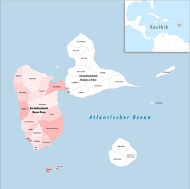 Location within the region Guadeloupe | |
| Country | France |
| Overseas region and department | Guadeloupe |
| No. of communes | 18 |
| Prefecture | Basse-Terre |
| Area | 854.3 km2 (329.8 sq mi) |
| Population | 184,765 |
| • Density | 216/km2 (560/sq mi) |
| INSEE code | 9711 |
Composition
The communes of the arrondissement of Basse-Terre, and their INSEE codes, are:[2]
- Baie-Mahault (97103)
- Baillif (97104)
- Basse-Terre (97105)
- Bouillante (97106)
- Capesterre-Belle-Eau (97107)
- Deshaies (97111)
- Gourbeyre (97109)
- Goyave (97114)
- Lamentin (97115)
- Petit-Bourg (97118)
- Pointe-Noire (97121)
- Saint-Claude (97124)
- Sainte-Rose (97129)
- Terre-de-Bas (97130)
- Terre-de-Haut (97131)
- Trois-Rivières (97132)
- Vieux-Fort (97133)
- Vieux-Habitants (97134)
History
The arrondissement of Basse-Terre was established in 1947.[4] The arrondissement of Saint-Martin-Saint-Barthélemy, containing the communes of Saint-Martin and Saint-Barthélemy, was created in 1963 from part of the arrondissement of Basse-Terre.[5]
As a result of the reorganisation of the cantons of France which came into effect in 2015, the borders of the cantons are no longer related to the borders of the arrondissements. The cantons of the arrondissement of Basse-Terre were, as of January 2015:[6]
- Baie-Mahault
- Basse-Terre-1
- Basse-Terre-2
- Bouillante
- Capesterre-Belle-Eau-1
- Capesterre-Belle-Eau-2
- Gourbeyre
- Goyave
- Lamentin
- Petit-Bourg
- Pointe-Noire
- Saint-Claude
- Sainte-Rose-1
- Sainte-Rose-2
- Les Saintes
- Trois-Rivières
- Vieux-Habitants
References
- "Téléchargement du fichier d'ensemble des populations légales en 2019". The National Institute of Statistics and Economic Studies. 28 December 2020.
- "Arrondissement de Basse-Terre (9711)". INSEE. Retrieved 2019-10-05.
- "Comparateur de territoire, géographie au 01/01/2019". INSEE. Retrieved 2019-10-05.
- Décret n° 47-1018 du 7 juin 1947 relatif à l'organisation départementale et à l'institution préfectorale dans les départements de la Guadeloupe, de la Guyane française, de la Martinique et de la Réunion
- Décret n°63-89 du 1 février 1963 portant création de l'arrondissement de Saint-Martin-Saint-Barthélemy dans le département de la Guadeloupe
- Populations légales 2012: 971 Guadeloupe, INSEE
|
На других языках
- [en] Arrondissement of Basse-Terre
[ru] Бас-Тер (округ)
Бас-Те́р (фр. Basse-Terre) — округ (фр. Arrondissement) во Франции, один из округов в регионе Гваделупа. Департамент округа — Гваделупа. Супрефектура — Бас-Тер. Население округа на 2006 год составляло 189 529 человек. Плотность населения составляет 221,93 чел./км². Площадь округа составляет всего 854 км².Другой контент может иметь иную лицензию. Перед использованием материалов сайта WikiSort.org внимательно изучите правила лицензирования конкретных элементов наполнения сайта.
WikiSort.org - проект по пересортировке и дополнению контента Википедии