world.wikisort.org - Frankreich
Saint-Chaffrey (auf okzitanisch Sant Chafrèi) ist eine französische Gemeinde im Département Hautes-Alpes in der Region Provence-Alpes-Côte d’Azur. Sie gehört zum Arrondissement Briançon und zum Kanton Briançon-1.
| Saint-Chaffrey | ||
|---|---|---|
|
| |
| Staat | Frankreich | |
| Region | Provence-Alpes-Côte d’Azur | |
| Département (Nr.) | Hautes-Alpes (05) | |
| Arrondissement | Briançon | |
| Kanton | Briançon-1 | |
| Gemeindeverband | Briançonnais | |
| Koordinaten | 44° 56′ N, 6° 36′ O | |
| Höhe | 1274–2413 m | |
| Fläche | 25,65 km² | |
| Einwohner | 1.531 (1. Januar 2019) | |
| Bevölkerungsdichte | 60 Einw./km² | |
| Postleitzahl | 05330 | |
| INSEE-Code | 05133 | |
 Mairie Saint-Chaffrey | ||

Geographie
Das Dorf liegt auf 1365 m im Tal des Flusses Guisane. Der Col de Granon ist ein 2413 m hoher Pass bei Saint-Chaffrey.
Die angrenzenden Gemeinden sind:
- Val-des-Prés im Nordosten,
- Briançon und Puy-Saint-Pierre im Südosten,
- Puy-Saint-André im Südwesten,
- La Salle-les-Alpes im Nordwesten.
Bevölkerungsentwicklung
| Jahr | 1962 | 1968 | 1975 | 1982 | 1990 | 1999 | 2008 | 2012 |
|---|---|---|---|---|---|---|---|---|
| Einwohner | 844 | 831 | 947 | 1.287 | 1.424 | 1.569 | 1.662 | 1.663 |
Sehenswürdigkeiten
- Haus mit Sonnenuhr von Zarbula, Monument historique
- Kirche Saint-Arnould, Monument historique
- Kirche Saint-Chaffrey, Monument historique
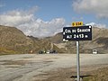 Col du Granon
 Kirche Saint-Chaffrey


Weblinks
Commons: Saint-Chaffrey – Sammlung von Bildern, Videos und Audiodateien
На других языках
- [de] Saint-Chaffrey
[en] Saint-Chaffrey
Saint-Chaffrey (French pronunciation: [sɛ̃ ʃafʁɛ]; Occitan: Sant Chafrei) is a commune in the Hautes-Alpes department in the Provence-Alpes-Côte d'Azur region in Southeastern France. In 2018, it had a population of 1,567. An alpine commune, Saint-Chaffrey is located in the Valley of the Guisane, on the road to Grenoble, between La Salle-les-Alpes to the northwest and Briançon to the southeast.[ru] Сен-Шафре
Сен-Шафре́ (фр. Saint-Chaffrey, окс. Sant Chafrei) — коммуна во Франции, находится в регионе Прованс — Альпы — Лазурный Берег. Департамент коммуны — Верхние Альпы. Входит в состав кантона Ле-Монетье-ле-Бен. Округ коммуны — Бриансон.Текст в блоке "Читать" взят с сайта "Википедия" и доступен по лицензии Creative Commons Attribution-ShareAlike; в отдельных случаях могут действовать дополнительные условия.
Другой контент может иметь иную лицензию. Перед использованием материалов сайта WikiSort.org внимательно изучите правила лицензирования конкретных элементов наполнения сайта.
Другой контент может иметь иную лицензию. Перед использованием материалов сайта WikiSort.org внимательно изучите правила лицензирования конкретных элементов наполнения сайта.
2019-2026
WikiSort.org - проект по пересортировке и дополнению контента Википедии
WikiSort.org - проект по пересортировке и дополнению контента Википедии