world.wikisort.org - Frankreich
La Chapelle-Huon ist eine französische Gemeinde mit 528 Einwohnern (Stand: 1. Januar 2019) im Département Sarthe in der Region Pays de la Loire; sie gehört zum Arrondissement Mamers und zum Kanton Saint-Calais. Die Einwohner werden Capellhuonnais genannt.
| La Chapelle-Huon | ||
|---|---|---|
| ||
| Staat | Frankreich | |
| Region | Pays de la Loire | |
| Département (Nr.) | Sarthe (72) | |
| Arrondissement | Mamers | |
| Kanton | Saint-Calais | |
| Gemeindeverband | Vallées de la Braye et de l’Anille | |
| Koordinaten | 47° 51′ N, 0° 45′ O | |
| Höhe | 67–156 m | |
| Fläche | 18,71 km² | |
| Einwohner | 528 (1. Januar 2019) | |
| Bevölkerungsdichte | 28 Einw./km² | |
| Postleitzahl | 72310 | |
| INSEE-Code | 72064 | |

Geographie
La Chapelle-Huon liegt etwa 35 Kilometer ostsüdöstlich von Le Mans. Umgeben wird La Chapelle-Huon von den Nachbargemeinden Saint-Gervais-de-Vic im Norden, Savigny-sur-Braye im Nordosten, Bonneveau im Südosten, Bessé-sur-Braye im Süden, Vancé im Südwesten sowie Cogners im Westen und Nordwesten.
Bevölkerungsentwicklung
| 1962 | 1968 | 1975 | 1982 | 1990 | 1999 | 2006 | 2013 |
|---|---|---|---|---|---|---|---|
| 563 | 511 | 503 | 458 | 537 | 591 | 525 | 545 |
| Quelle: Cassini und INSEE | |||||||
Sehenswürdigkeiten
- Kirche Saint-André, seit 1926 Monument historique
- Mühle Guillaume
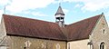 Kirche Saint-André
 Mühle Guillaume


Gemeindepartnerschaften
Eine Partnerschaft besteht mit der deutschen Samtgemeinde Kirchdorf in Niedersachsen.
Weblinks
Commons: La Chapelle-Huon – Sammlung von Bildern, Videos und Audiodateien
На других языках
- [de] La Chapelle-Huon
[en] La Chapelle-Huon
La Chapelle-Huon is a commune in the Sarthe department in the Pays de la Loire region in north-western France. La Chapelle-Huon (Latin Capella Hugonie) is named after one of its ancient lords, named Hugo. His name appears for the first time in 1233 under the name of Capella Parrochia Hugonie. Its inhabitants are called Capellhuonnais and Capellhuonnaises. It is located 7.5 km from Saint-Calais and 44 miles from Le Mans, and once depended on the deanery of Saint-Calais, the Archdeaconry of Montfort, and the diocese of Le Mans. It is in the department of Sarthe, which is since 1790 the eastern part of the former province of Maine. This town is bounded on the north by Saint-Gervais-de-Vic, on the east by Savigny-sur-Braye, south by Besse-sur-Braye, and west by Cogners . Egg-shaped, it extends the SSO NO. The village forms several small streets north of the church, and a row of houses to the west.[citation needed]Текст в блоке "Читать" взят с сайта "Википедия" и доступен по лицензии Creative Commons Attribution-ShareAlike; в отдельных случаях могут действовать дополнительные условия.
Другой контент может иметь иную лицензию. Перед использованием материалов сайта WikiSort.org внимательно изучите правила лицензирования конкретных элементов наполнения сайта.
Другой контент может иметь иную лицензию. Перед использованием материалов сайта WikiSort.org внимательно изучите правила лицензирования конкретных элементов наполнения сайта.
2019-2026
WikiSort.org - проект по пересортировке и дополнению контента Википедии
WikiSort.org - проект по пересортировке и дополнению контента Википедии