world.wikisort.org - Frankreich
Chaintreaux ist eine französische Gemeinde mit 864 Einwohnern (Stand: 1. Januar 2019) im Département Seine-et-Marne in der Region Île-de-France. Sie gehört zum Arrondissement Fontainebleau und zum Kanton Nemours.
| Chaintreaux | ||
|---|---|---|
| ||
| Staat | Frankreich | |
| Region | Île-de-France | |
| Département (Nr.) | Seine-et-Marne (77) | |
| Arrondissement | Fontainebleau | |
| Kanton | Nemours | |
| Gemeindeverband | Gâtinais-Val de Loing | |
| Koordinaten | 48° 12′ N, 2° 49′ O | |
| Höhe | 88–133 m | |
| Fläche | 23,86 km² | |
| Einwohner | 864 (1. Januar 2019) | |
| Bevölkerungsdichte | 36 Einw./km² | |
| Postleitzahl | 77460 | |
| INSEE-Code | 77071 | |
 Mairie Chaintreaux | ||

Geographie
Chaintreaux liegt fünf Kilometer nordwestlich von Égreville und sieben Kilometer östlich von Souppes-sur-Loing.
| Poligny | Remauville | Lorrez-le-Bocage-Préaux |
| Souppes-sur-Loing |  |
Égreville |
| Dordives | Bransles |
Sehenswürdigkeiten
Siehe auch: Liste der Monuments historiques in Chaintreaux
- Kirche St. Peter-und-Paul
 Kirche Saint-Eutrope im Ortsteil Lagerville
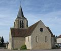 Kirche St. Peter-und-Paul
 Kriegerdenkmal


Literatur
- Le Patrimoine des Communes de la Seine-et-Marne. Flohic Editions, Band 1, Paris 2001, ISBN 2-84234-100-7, S. 191–193.
Weblinks
Commons: Chaintreaux – Sammlung von Bildern, Videos und Audiodateien
- Chaintreaux bei annuaire-mairie.fr (französisch)
На других языках
- [de] Chaintreaux
[en] Chaintreaux
Chaintreaux (French pronunciation: [ʃɛ̃tʁo] (listen)) is a commune in the Seine-et-Marne department in the Île-de-France region in north-central France about one hour south of Paris. It is part of the Canton of Château-Landon and borders the Department of Loiret in the southern part. Agriculture is the main activity in this rural commune with about twenty mixed purpose farms. The cereals produced are wheat, barley and rapeseed.Текст в блоке "Читать" взят с сайта "Википедия" и доступен по лицензии Creative Commons Attribution-ShareAlike; в отдельных случаях могут действовать дополнительные условия.
Другой контент может иметь иную лицензию. Перед использованием материалов сайта WikiSort.org внимательно изучите правила лицензирования конкретных элементов наполнения сайта.
Другой контент может иметь иную лицензию. Перед использованием материалов сайта WikiSort.org внимательно изучите правила лицензирования конкретных элементов наполнения сайта.
2019-2026
WikiSort.org - проект по пересортировке и дополнению контента Википедии
WikiSort.org - проект по пересортировке и дополнению контента Википедии