world.wikisort.org - Czech
Veselí nad Lužnicí (Czech pronunciation: [ˈvɛsɛliː ˈnadluʒɲɪtsiː]; German: Wesseli an der Lainsitz) is a town in Tábor District in the South Bohemian Region of the Czech Republic. It has about 6,300 inhabitants. It lies at the confluence of the Lužnice and Nežárka rivers.
Veselí nad Lužnicí | |
|---|---|
Town | |
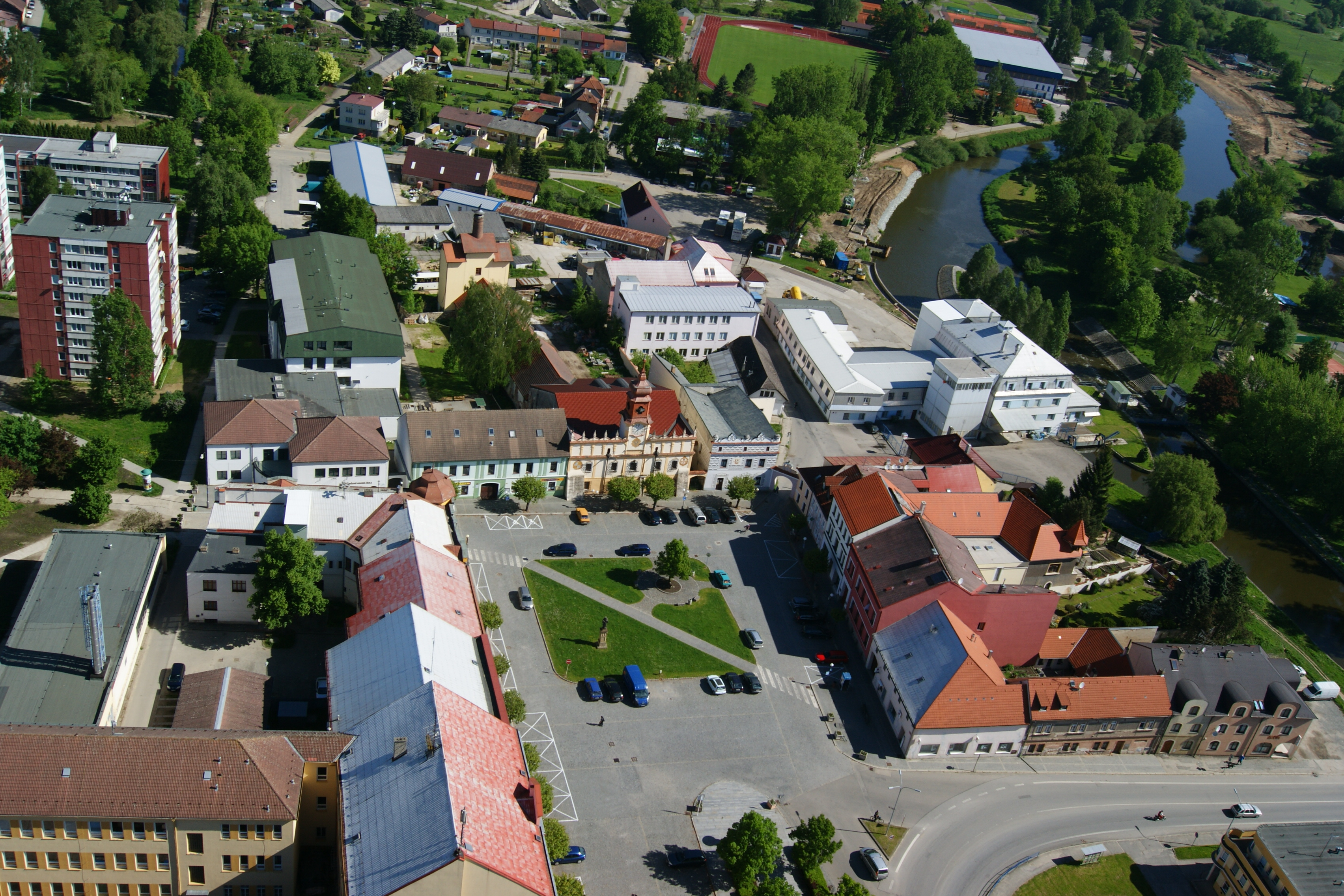 Town square | |
 Flag  Coat of arms | |
 Veselí nad Lužnicí Location in the Czech Republic | |
| Coordinates: 49°11′12″N 14°41′56″E | |
| Country | |
| Region | South Bohemian |
| District | Tábor |
| First mentioned | 1259 |
| Government | |
| • Mayor | Vít Rada |
| Area | |
| • Total | 29.57 km2 (11.42 sq mi) |
| Elevation | 407 m (1,335 ft) |
| Population (2022-01-01)[1] | |
| • Total | 6,317 |
| • Density | 210/km2 (550/sq mi) |
| Time zone | UTC+1 (CET) |
| • Summer (DST) | UTC+2 (CEST) |
| Postal code | 391 81 |
| Website | www |
Administrative parts

The town is made up of town parts of Veselí nad Lužnicí I and Veselí nad Lužnicí II, and village of Horusice.
Geography
Veselí nad Lužnicí is located about 25 kilometres (16 mi) south of Tábor and 27 km (17 mi) northeast of České Budějovice. It lies at the confluence of the Lužnice and Nežárka rivers.
Veselí nad Lužnicí is situated on the northern edge of the Třeboň Basin and is known for its fish ponds and pine forests. There are five artificial lakes south of the town, used for recreational purposes; these were created between 1952 and 1986 by flooding former gravel and sand quarries. An educational trail runs around them.[2]
Horusický pond, the second largest pond in the country with 415 hectares (1,030 acres), lies southwest of the town. The southern part of the municipal territory lies in the Třeboňsko Protected Landscape Area, which was declared an UNESCO biosphere reserve.
History
The town was first mentioned in 1259 as a hamlet and a redoubt on the salt road from Austria to Prague. King Charles IV gave it the status of a town in 1362. In the 15th century, the town saw many fires and was looted by the Hussites. It was Peter Vok of Rosenberg, a famous fish pond founder and supporter, who let the town grow again a hundred years later.[3]
The Thirty Years' War (1618–1648) damaged the town badly again – with only 69 people remaining. New development came with the Schwarzenberg dynasty in the second half of the 17th century. Veselí stayed in their possession until the end of the World War I in 1918.[3]
It was originally two separate towns – Veselí nad Lužnicí and Mezimostí nad Nežárkou (a town since 1908). They were joined in 1943 to make one town under the present name.[3]
Demographics
|
|
| ||||||||||||||||||||||||||||||||||||||||||||||||||||||
| Source: Censuses[4][5] | ||||||||||||||||||||||||||||||||||||||||||||||||||||||||
Economy
The railway station is one of the biggest local employers. The sand quarrying, concrete production and food industries are also long-established in the town.
Transport
Since the late 19th century, Veselí nad Lužnicí has been an important railway junction between České Budějovice, Tábor, Třeboň and Jindřichův Hradec.
The D3 motorway runs next to the town.
Sights

The renaissance Old Town Hall from 1616 is the main building on the square and together with the neighbouring museum, which was also built in 1616, forms an architectonic unit. The New Town Hall was built in 1897.[6]
The Church of the Exaltation of the Holy Cross is the main landmark. Its existence was first mentioned in 1259 and is the oldest monument in the town. Chapel of Saint Mark (1754) and the Chapel of St. Florian in Mezimostí (1715) are other notable buildings.[6]
Notable people
- Karel Weis (1862–1944), composer, collector of folk songs and folklorist; worked here
- Karel Traxler (1866–1936), chess master; lived here
- Emil Hlobil (1901–1987), composer and music professor
- Lubomír Štrougal (born 1924), politician and prime minister
- Saša Večtomov (1930–1989), cellist; buried here
- Vladimír Večtomov (1946–2015), guitarist
Twin towns – sister cities
Veselí nad Lužnicí is twinned with:[7]
 Diemtigen, Switzerland
 Yspertal, Austria
Veselí nad Lužnicí also cooperates with other Czech municipalities and villages with Veselí in their names.[7]
References
- "Population of Municipalities – 1 January 2022". Czech Statistical Office. 2022-04-29.
- "Veselské pískovny – koupání jako u moře" (in Czech). CzechTourism. Retrieved 2022-07-08.
- "Z historie města" (in Czech). Město Veselí nad Lužnicí. Retrieved 2021-02-17.
- "Historický lexikon obcí České republiky 1869–2011 – Okres Tábor" (in Czech). Czech Statistical Office. 2015-12-21. pp. 21–22.
- "Population Census 2021: Population by sex". Public Database. Czech Statistical Office. 2021-03-27.
- "Památky" (in Czech). Město Veselí nad Lužnicí. Retrieved 2021-09-10.
- "Partnerská města a obce" (in Czech). Město Veselí nad Lužnicí. Retrieved 2020-08-25.
External links
Authority control | |
|---|---|
| General |
|
| National libraries | |
Другой контент может иметь иную лицензию. Перед использованием материалов сайта WikiSort.org внимательно изучите правила лицензирования конкретных элементов наполнения сайта.
WikiSort.org - проект по пересортировке и дополнению контента Википедии