world.wikisort.org - Czech
Sudoměřice is a municipality and village in Hodonín District in the South Moravian Region of the Czech Republic. It has about 1,300 inhabitants.
Sudoměřice | |
|---|---|
Municipality | |
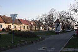
 Main street | |
 Sudoměřice Location in the Czech Republic | |
| Coordinates: 48°52′2″N 17°15′24″E | |
| Country | |
| Region | South Moravian |
| District | Hodonín |
| First mentioned | 1368 |
| Area | |
| • Total | 9.33 km2 (3.60 sq mi) |
| Elevation | 182 m (597 ft) |
| Population (2022-01-01)[1] | |
| • Total | 1,265 |
| • Density | 140/km2 (350/sq mi) |
| Time zone | UTC+1 (CET) |
| • Summer (DST) | UTC+2 (CEST) |
| Postal code | 696 66 |
| Website | www |
Geography
Sudoměřice is located about 9 kilometres (6 mi) east of Hodonín, on the border with Slovakia. It lies in a flat landscape of the Lower Morava Valley. The Baťa Canal flows through the municipality.
Sights
A technical monument is the Sudoměřice coal tipper. The tipper was used to transfer lignite to ships on the Baťa Canal, which was brought by rail from a nearby mine. It dates from 1939. Today it serves as a lookout tower, and in its interior there is an exhibition about its function.[2]
References
- "Population of Municipalities – 1 January 2022". Czech Statistical Office. 2022-04-29.
- "Technická památka Výklopník na Baťově kanále" (in Czech). CzechTourism. Retrieved 2022-06-29.
| Wikimedia Commons has media related to Sudoměřice. |
Текст в блоке "Читать" взят с сайта "Википедия" и доступен по лицензии Creative Commons Attribution-ShareAlike; в отдельных случаях могут действовать дополнительные условия.
Другой контент может иметь иную лицензию. Перед использованием материалов сайта WikiSort.org внимательно изучите правила лицензирования конкретных элементов наполнения сайта.
Другой контент может иметь иную лицензию. Перед использованием материалов сайта WikiSort.org внимательно изучите правила лицензирования конкретных элементов наполнения сайта.
2019-2025
WikiSort.org - проект по пересортировке и дополнению контента Википедии
WikiSort.org - проект по пересортировке и дополнению контента Википедии


