world.wikisort.org - Czech
Slavičín (Czech pronunciation: [ˈslavɪtʃiːn]) is a town in Zlín District in the Zlín Region of the Czech Republic. It has about 6,200 inhabitants.
Slavičín | |
|---|---|
Town | |
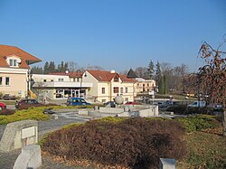
 Horní Square | |
 Slavičín Location in the Czech Republic | |
| Coordinates: 49°5′17″N 17°52′25″E | |
| Country | |
| Region | Zlín |
| District | Zlín |
| First mentioned | 1141 |
| Government | |
| • Mayor | Tomáš Chmela |
| Area | |
| • Total | 33.61 km2 (12.98 sq mi) |
| Elevation | 350 m (1,150 ft) |
| Population (2022-01-01)[1] | |
| • Total | 6,227 |
| • Density | 190/km2 (480/sq mi) |
| Time zone | UTC+1 (CET) |
| • Summer (DST) | UTC+2 (CEST) |
| Postal code | 763 21 |
| Website | www |
Administrative parts
Villages of Divnice, Hrádek na Vlárské dráze and Nevšová are administrative parts of Slavičín.
Geography
Slavičín is located about 24 kilometres (15 mi) southeast of Zlín. It lies in the Vizovice Highlands, on the Říka stream.
History
The first written mention of Slavičín is from 1141. For centuries, it was mostly an agricultural village where the craft did not flourish much. In 1860 a tannery was founded here, which was later expanded by a shoe factory. In 1936, an engineering company was established and Slavičín became an industrial village. After the World War II Slavičín further expanded, and in 1964 it became a town.[2]
Demographics
|
|
| ||||||||||||||||||||||||||||||||||||||||||||||||||||||
| Source: Censuses[3][4] | ||||||||||||||||||||||||||||||||||||||||||||||||||||||||
Sights
The cemetery Church of Saint Adalbert is the oldest building in the town. The original church was from the 13th century. After it was destroyed by a fire, it was completely rebuilt in the Baroque style in 1897.[5]
The Slavičín Castle was built in the Baroque style in 1750. Today it serves as a restaurant.[6]
Notable people
- Lumír Krejčí (born 1972), biochemist
- Tomáš Řepka (born 1974), footballer
- Tomáš Polách (born 1977), footballer
- Lenny Trčková (born 1978), presenter and model
- Petra Polášková (born 1979), footballer
- Stanislav Polčák (born 1980), politician
- Aleš Urbánek (born 1980), footballer
- Zdeněk Hřib (born 1981), politician, Mayor of Prague
Twin towns – sister cities
Slavičín is twinned with:[7]
 Horná Súča, Slovakia
 Horné Srnie, Slovakia
 Nová Dubnica, Slovakia
 Uhrovec, Slovakia
References
- "Population of Municipalities – 1 January 2022". Czech Statistical Office. 2022-04-29.
- "Město Slavičín" (in Czech). Město Slavičín. Retrieved 2022-01-03.
- "Historický lexikon obcí České republiky 1869–2011 – Okres Zlín" (in Czech). Czech Statistical Office. 2015-12-21. pp. 5–6.
- "Population Census 2021: Population by sex". Public Database. Czech Statistical Office. 2021-03-27.
- "Kostel sv. Vojtěcha" (in Czech). Město Slavičín. Retrieved 2022-01-03.
- "Zámek Slavičín" (in Czech). Město Slavičín. Retrieved 2022-01-03.
- "Partnerská města a obce" (in Czech). Město Slavičín. Retrieved 2022-10-04.
External links
На других языках
[de] Slavičín
Slavičín (deutsch Slawitschin) ist eine Stadt in Tschechien. Sie liegt 18 Kilometer nordöstlich von Uherský Brod und gehört zum Okres Zlín.- [en] Slavičín
Другой контент может иметь иную лицензию. Перед использованием материалов сайта WikiSort.org внимательно изучите правила лицензирования конкретных элементов наполнения сайта.
WikiSort.org - проект по пересортировке и дополнению контента Википедии


