world.wikisort.org - Czech
Seč (German: Setsch) is a town in Chrudim District in the Pardubice Region of the Czech Republic. It has about 1,700 inhabitants.
Seč | |
|---|---|
Town | |
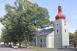
 Church of Saint Lawrence | |
 Seč Location in the Czech Republic | |
| Coordinates: 49°50′49″N 15°39′23″E | |
| Country | |
| Region | Pardubice |
| District | Chrudim |
| First mentioned | 1318 |
| Government | |
| • Mayor | Marcel Vojtěch |
| Area | |
| • Total | 36.68 km2 (14.16 sq mi) |
| Elevation | 532 m (1,745 ft) |
| Population (2022-01-01)[1] | |
| • Total | 1,738 |
| • Density | 47/km2 (120/sq mi) |
| Time zone | UTC+1 (CET) |
| • Summer (DST) | UTC+2 (CEST) |
| Postal codes | 538 05, 538 07, 538 43 |
| Website | www |
Administrative parts
Villages of Hoješín, Javorka, Kraskov, Počátky, Proseč, Prosíčka, Přemilov, Ústupky and Žďárec u Seče are administrative parts of Seč.
Geography
Seč is located about 15 kilometres (9 mi) southwest of Chrudim and 22 km (14 mi) southwest of Pardubice. It lies in the Iron Mountains and in the eponymous protected landscape area. Seč Dam is built next to the town on the river Chrudimka.
History
The first written mention of Seč is from 1318. The settlement was founded during the colonization of the Iron Mountains in the 12th and 13th centuries. In 1499, Seč became a market town, and in 1853, it was promoted to a town. It lost the town status in 1954 and regained it in 2007.[2]
Notable people
- Vincenc Strouhal (1850–1922), physicist
Sights
The landmarks of the town are the Church of Saint Lawrence, built in the Renaissance style in 1610–1620, and the Renaissance castle, which dates from the turn of the 16th and 17th centuries and today serves as the municipal office.[2]
Twin towns – sister cities
Seč is twinned with:[3]
 Radzovce, Slovakia
References
- "Population of Municipalities – 1 January 2022". Czech Statistical Office. 2022-04-29.
- "O městě" (in Czech). Město Seč. Retrieved 2022-07-12.
- "Oheb – Zpravodaj města Seč 2/2019" (in Czech). Město Seč. June 2019. p. 5. Retrieved 2020-08-25.
External links
Другой контент может иметь иную лицензию. Перед использованием материалов сайта WikiSort.org внимательно изучите правила лицензирования конкретных элементов наполнения сайта.
WikiSort.org - проект по пересортировке и дополнению контента Википедии


