world.wikisort.org - Czech
Kovářov is a municipality and village in Písek District in the South Bohemian Region of the Czech Republic. It has about 1,400 inhabitants.
Kovářov | |
|---|---|
Municipality | |
 Common in Kovářov | |
 Flag  Coat of arms | |
 Kovářov Location in the Czech Republic | |
| Coordinates: 49°31′4″N 14°16′41″E | |
| Country | |
| Region | South Bohemian |
| District | Písek |
| First mentioned | 1220 |
| Area | |
| • Total | 50.46 km2 (19.48 sq mi) |
| Elevation | 461 m (1,512 ft) |
| Population (2022-01-01)[1] | |
| • Total | 1,448 |
| • Density | 29/km2 (74/sq mi) |
| Time zone | UTC+1 (CET) |
| • Summer (DST) | UTC+2 (CEST) |
| Postal code | 398 55 |
| Website | www |
Administrative parts
Villages and hamlets of Březí, Chrást, Dobrá Voda, Hostín, Kotýřina, Lašovice, Onen Svět, Předbořice, Radvánov, Řenkov, Vepice, Vesec, Vladyčín, Zahořany, Záluží and Žebrákov are administrative parts of Kovářov.
Geography
Kovářov is located about 25 kilometres (16 mi) northeast of Písek and 56 km (35 mi) south of Prague. The eastern part of the municipal territory with the Kovářov village lies in the Vlašim Upland. The western part lies in the Benešov Uplands and borders the Orlík Reservoir. The highest point is the hill Koňský vrch at 587 metres (1,926 ft) above sea level. The territory is rich in small ponds.
History
The first written mention of Kovářov is from 1220.[2]
Sights
The landmark of Kovářov is the Church of All Saints. The early Gothic church from the 13th century was expanded with Baroque towers in 1712.[3]
Notable people
- Jan of Předbořice, 14th century priest and abbot
Twin towns – sister cities
Kovářov is twinned with:[4]
 Seftigen, Switzerland
Gallery
 Rectory
 Restaurant
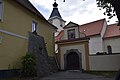 Gate of the cemetery


References
- "Population of Municipalities – 1 January 2022". Czech Statistical Office. 2022-04-29.
- "Historie" (in Czech). Obec Kovářov. Retrieved 2022-08-31.
- "Kostel Všech svatých Kovářov" (in Czech). CzechTourism. Retrieved 2022-08-31.
- "Partnerství" (in Czech). Obec Kovářov. Retrieved 2022-08-31.
External links
Authority control | |
|---|---|
| General |
|
| National libraries | |
На других языках
[de] Kovářov
Kovářov (deutsch Kowarschow) ist eine Gemeinde in Tschechien. Sie liegt zehn Kilometer nordwestlich von Milevsko und gehört zum Okres Písek.- [en] Kovářov
Другой контент может иметь иную лицензию. Перед использованием материалов сайта WikiSort.org внимательно изучите правила лицензирования конкретных элементов наполнения сайта.
WikiSort.org - проект по пересортировке и дополнению контента Википедии