world.wikisort.org - Czech
Klášterec nad Orlicí (German: Klösterle an der Adler) is a municipality and village in Ústí nad Orlicí District in the Pardubice Region of the Czech Republic. It has about 900 inhabitants. It is located on the Divoká Orlice river.
Klášterec nad Orlicí | |
|---|---|
Municipality | |
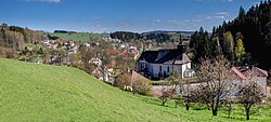
 Panorama of Klášterec nad Orlicí | |
 Flag  Coat of arms | |
 Klášterec nad Orlicí Location in the Czech Republic | |
| Coordinates: 50°6′42″N 16°33′16″E | |
| Country | |
| Region | Pardubice |
| District | Ústí nad Orlicí |
| First mentioned | 1279 |
| Area | |
| • Total | 17.95 km2 (6.93 sq mi) |
| Elevation | 490 m (1,610 ft) |
| Population (2021-01-01)[1] | |
| • Total | 902 |
| • Density | 50/km2 (130/sq mi) |
| Time zone | UTC+1 (CET) |
| • Summer (DST) | UTC+2 (CEST) |
| Postal code | 561 82 |
| Website | www |
Klášterec nad Orlicí lies approximately 8 kilometres (5 mi) north-east of Žamberk, 57 km (35 mi) east of Pardubice, and 153 km (95 mi) east of Prague.
History
The first written mention of the village, originally named Orlitz (Orlík) and Orlička, dates from 1279 and is recorded in a public document, the bull of Pope Boniface VIII of December 15, 1295. Another mention is from the "Form" of Tobias of Bechyně, in which he praises the intention to build a monastery here in this landscape. The dating of these documents is between 1279 and 1290. From this it is evident that Orlitz was founded about 1280.
Administrative parts
Villages of Čihák, Jedlina, Lhotka and Zbudov are administrative parts of Klášterec nad Orlicí.
References
- "Population of Municipalities – 1 January 2021". Czech Statistical Office. 2021-04-30.
External links
| Wikimedia Commons has media related to Klášterec nad Orlicí. |
На других языках
[de] Klášterec nad Orlicí
Klášterec nad Orlicí (deutsch Klösterle) ist eine Gemeinde im Okres Ústí nad Orlicí in Tschechien. Vier Kilometer nordöstlich von Klášterec verläuft die Grenze zum Powiat Kłodzki in Polen. In einer Entfernung von sechs Kilometern südwestlich liegt Žamberk.- [en] Klášterec nad Orlicí
Другой контент может иметь иную лицензию. Перед использованием материалов сайта WikiSort.org внимательно изучите правила лицензирования конкретных элементов наполнения сайта.
WikiSort.org - проект по пересортировке и дополнению контента Википедии