world.wikisort.org - Czech
Dobrovítov is a municipality and village in Kutná Hora District in the Central Bohemian Region of the Czech Republic. It has about 100 inhabitants.
Dobrovítov | |
|---|---|
Municipality | |
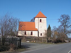
 Church of Saint Wenceslaus | |
 Dobrovítov Location in the Czech Republic | |
| Coordinates: 49°47′15″N 15°19′44″E | |
| Country | |
| Region | Central Bohemian |
| District | Kutná Hora |
| First mentioned | 1355 |
| Area | |
| • Total | 9.01 km2 (3.48 sq mi) |
| Elevation | 487 m (1,598 ft) |
| Population (2022-01-01)[1] | |
| • Total | 123 |
| • Density | 14/km2 (35/sq mi) |
| Time zone | UTC+1 (CET) |
| • Summer (DST) | UTC+2 (CEST) |
| Postal code | 286 01 |
| Website | www |
Administrative parts
The village of Dědice is an administrative part of Dobrovítov.
Geography
Dobrovítov is located about 19 kilometres (12 mi) south of Kutná Hora and 64 km (40 mi) southeast of Prague. It lies in the Upper Sázava Hills. The Klejnárka River flows through the municipality.
History
The first written mention of Dobrovítov is from 1355.[2]
References
- "Population of Municipalities – 1 January 2022". Czech Statistical Office. 2022-04-29.
- "Historie" (in Czech). Obec Dobrovítov. Retrieved 2022-09-13.
Wikimedia Commons has media related to Dobrovítov.
Текст в блоке "Читать" взят с сайта "Википедия" и доступен по лицензии Creative Commons Attribution-ShareAlike; в отдельных случаях могут действовать дополнительные условия.
Другой контент может иметь иную лицензию. Перед использованием материалов сайта WikiSort.org внимательно изучите правила лицензирования конкретных элементов наполнения сайта.
Другой контент может иметь иную лицензию. Перед использованием материалов сайта WikiSort.org внимательно изучите правила лицензирования конкретных элементов наполнения сайта.
2019-2025
WikiSort.org - проект по пересортировке и дополнению контента Википедии
WikiSort.org - проект по пересортировке и дополнению контента Википедии