world.wikisort.org - Croatia
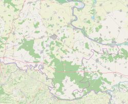
Šarengrad (Serbian Cyrillic: Шаренград, Hungarian: Atya, German: Wetterwardein) is a village in eastern Croatia. It is located along the Danube river and is administratively part of Croatian easternmost town of Ilok. Šarengrad is known for its landscape which is dominated by the river and picturesque houses and church tower next to it. Island of Šarengrad is an 9 km2 river island situated close to the village.
Šarengrad | |
|---|---|
Village (Selo) | |
 Šarengrad | |
 | |
 Šarengrad  Šarengrad Šarengrad | |
| Coordinates: 45°13′52″N 19°16′48″E | |
| Country | |
| County | |
| Municipality | Ilok |
| Elevation | 92 m (302 ft) |
| Population (2011)[1] | |
| • Total | 528 |
| Time zone | UTC+1 (CET) |
| • Summer (DST) | UTC+2 (CEST) |
| Postal code | 32234 Šarengrad |
| Area code(s) | +385 0(32) |

Geography
The village is located in the Syrmia region, on the Fruška Gora slopes, next to the Danube river.
Demographics
According to the 2011 census, Šarengrad had 528 inhabitants.[2]
| Population[3] | |||||||||||||||
|---|---|---|---|---|---|---|---|---|---|---|---|---|---|---|---|
| 1857 | 1869 | 1880 | 1890 | 1900 | 1910 | 1921 | 1931 | 1948 | 1953 | 1961 | 1971 | 1981 | 1991 | 2001 | 2011 |
| 1,265 | 1,484 | 1,424 | 1,558 | 1,489 | 1,472 | 1,392 | 1,448 | 1,349 | 1,622 | 1,443 | 1,357 | 1,106 | 1,005 | 838 | 528 |
1991 census
| Šarengrad[4] |
|---|
| 1991 |
total: 1,005 Croats 904 (89.95%) Serbs 48 (4.77%) Slovaks 7 (0.69%) Yugoslavs 6 (0.59%) Hungarians 4 (0.39%) Muslims 3 (0.29%) Slovenes 2 (0.19%) Germans 1 (0.09%) Macedonians 1 (0.09%) Montenegrins 1 (0.09%) others 2 (0.19%) nondeclared 10 (0.99%) unknown 16 (1.59%)
|
1910 census
| Šarengrad[5] | |
|---|---|
| Population by language | Population by religion |
total: 1,472 Rom. Cath. 1,188 (80.70%) East. Orthodox 242 (16.44%) East. Catholics 20 (1.35%) Calvinists 12 (0.81%) Jewish 8 (0.54%) Lutherans 2 (0.13%) - (-%) - (-%) - (-%)
| |
Gallery
 Main D2 road
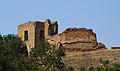 Medieval castle
 Yugoslav Partisans cemetery


See also
References
- "Vukovar-Srijem County - Town of Ilok". State Statistics Bureau of the Republic of Croatia. 2001. Retrieved 2010-09-13.
- "Državni zavod za statistiku Republike Hrvatske".
- - Republika Hrvatska - Državni zavod za statistiku: Naselja i stanovništvo Republike Hrvatske 1857.-2001.
- Book: "Ethnic and religious composition of population of Croatia, 1880-1991: by settlements", author: Jakov Gelo, publisher: Zagreb, Croatian bureau of statistics, 1998., ISBN 953-6667-07-X, ISBN 978-953-6667-07-9;
- Book: "Ethnic and religious composition of population of Croatia, 1880-1991: by settlements", author: Jakov Gelo, publisher: Zagreb, Croatian bureau of statistics, 1998., ISBN 953-6667-07-X, ISBN 978-953-6667-07-9;
External links
Wikimedia Commons has media related to Šarengrad.
Authority control | |
|---|---|
| General |
|
| National libraries | |
This Vukovar-Syrmia County geography article is a stub. You can help Wikipedia by expanding it. |
На других языках
- [en] Šarengrad
[ru] Шаренград
Шаренград (хорв. Šarengrad) — село в Хорватии на берегу Дуная, регион Срем, Вуковарско-Сремская жупания. Находится между Вуковаром и Илоком в районе гряды Фрушка-Гора. Вместе с сёлами Бабска и Мохово подчиняется Илокскому муниципалитету.Текст в блоке "Читать" взят с сайта "Википедия" и доступен по лицензии Creative Commons Attribution-ShareAlike; в отдельных случаях могут действовать дополнительные условия.
Другой контент может иметь иную лицензию. Перед использованием материалов сайта WikiSort.org внимательно изучите правила лицензирования конкретных элементов наполнения сайта.
Другой контент может иметь иную лицензию. Перед использованием материалов сайта WikiSort.org внимательно изучите правила лицензирования конкретных элементов наполнения сайта.
2019-2025
WikiSort.org - проект по пересортировке и дополнению контента Википедии
WikiSort.org - проект по пересортировке и дополнению контента Википедии