world.wikisort.org - Colombia
Yopal (Spanish pronunciation: [ɟ͡ʝoˈpal]) is a municipality and capital city of the department of Casanare in Colombia.
This article may be expanded with text translated from the corresponding article in Spanish. (March 2009) Click [show] for important translation instructions.
|
Yopal | |
|---|---|
Municipality and town | |
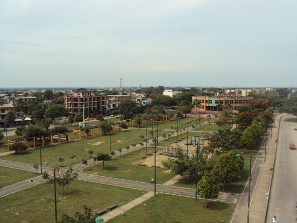
 Panorama view of Yopal, from La Iguana Natural Park (Parque Natural La Iguana) | |
 Flag  Seal | |
 Location of the municipality and town of Yopal in the Casanare Department of Colombia. | |
 Yopal Location in Colombia | |
| Coordinates: 5°21′0″N 72°24′36″W | |
| Country | |
| Region | Orinoquía Region |
| Department | Casanare Department |
| Founded | 1915 |
| Area | |
| • Municipality and town | 2,771 km2 (1,070 sq mi) |
| Elevation | 350 m (1,150 ft) |
| Population (2018 Census[1]) | |
| • Municipality and town | 168,433 |
| • Density | 61/km2 (160/sq mi) |
| • Urban | 143,619 |
| Demonym(s) | Yopaleño |
| Time zone | UTC-05 (Colombia Standard Time) |
| Postal code | 850001-9 |
| Area code(s) | 57 + 8 |
| Website | Official website (in Spanish) |
History
During the period of the Spanish colonization of the Americas, the land on which Yopal stands was occupied by the indigenous Achagua people. The name Yopal descends from the region's abundance of Anadenanthera peregrina, often otherwise called yopo.
Geographic information
- Population: 150 000 inhabitants
- Elevation: 350 metres or 1,150 feet
- Area: 2,771 square kilometres or 1,070 square miles
- Distance from Bogotá: 387 kilometres or 240 miles
- Median temperature: 26 °C or 78.8 °F

Climate
Yopal has a tropical monsoon climate (Köppen Am). Although it borders closely on a tropical savanna climate (Aw), Yopal’s climate is much more typical of a tropical monsoon climate in having a short but distinct dry season that covers the months of December to March, and a very long wet season covering the remaining eight months.
| Climate data for Yopal | |||||||||||||
|---|---|---|---|---|---|---|---|---|---|---|---|---|---|
| Month | Jan | Feb | Mar | Apr | May | Jun | Jul | Aug | Sep | Oct | Nov | Dec | Year |
| Average high °C (°F) | 32.5 (90.5) |
33.2 (91.8) |
33.2 (91.8) |
31.5 (88.7) |
30.8 (87.4) |
29.7 (85.5) |
29.9 (85.8) |
30.5 (86.9) |
30.7 (87.3) |
30.8 (87.4) |
31.1 (88.0) |
31.7 (89.1) |
31.3 (88.3) |
| Average low °C (°F) | 22.5 (72.5) |
22.9 (73.2) |
23.7 (74.7) |
22.6 (72.7) |
22.3 (72.1) |
21.7 (71.1) |
21.5 (70.7) |
21.4 (70.5) |
21.5 (70.7) |
21.6 (70.9) |
21.9 (71.4) |
22.2 (72.0) |
22.2 (71.9) |
| Average rainfall mm (inches) | 8.5 (0.33) |
60.4 (2.38) |
79.3 (3.12) |
279.0 (10.98) |
333.7 (13.14) |
298.0 (11.73) |
312.3 (12.30) |
255.4 (10.06) |
275.9 (10.86) |
255.0 (10.04) |
131.8 (5.19) |
20.2 (0.80) |
2,309.5 (90.93) |
| Average rainy days (≥ 1 mm) | 1 | 4 | 7 | 15 | 16 | 17 | 18 | 17 | 15 | 14 | 10 | 4 | 138 |
| Source: IDEAM | |||||||||||||
Born in Yopal
- Jeffry Romero, professional cyclist
- Andres Badillo Entrepreneur
- Mechs, streamer of League of Legends
References
External links
- (in Spanish) Yopal official website
- (in Spanish) La Voz de Yopal (Radio)
Municipalities in the Casanare Department | ||
|---|---|---|
| ||
Authority control | |
|---|---|
| General |
|
| National libraries | |
This Department of Casanare location article is a stub. You can help Wikipedia by expanding it. |
На других языках
- [en] Yopal
[ru] Йопаль
Йопа́ль (исп. Yopal) — город в Колумбии. Является административным центром муниципалитета и департамента Касанаре.Другой контент может иметь иную лицензию. Перед использованием материалов сайта WikiSort.org внимательно изучите правила лицензирования конкретных элементов наполнения сайта.
WikiSort.org - проект по пересортировке и дополнению контента Википедии