world.wikisort.org - China
Oksalur Township[1][2][6] (ئوقسالۇر يېزىسى[7] / Wuheshalu, Chinese: 吾合沙鲁乡; pinyin: Wúhéshālǔ Xiāng) is a township of Ulugqat County (Wuqia) in Kizilsu Kyrgyz Autonomous Prefecture, Xinjiang Uygur Autonomous Region, China. Located in the southwest of the county, the township covers an area of 1,745.5 square kilometers with a population of 1,031 (as of 2017). It has 2 villages under its jurisdiction. Its seat is at Qat Village (恰提村).
Oksalur
ئوقسالۇر يېزىسى 吾合沙鲁乡 Wuheshalu | |
|---|---|
Township | |
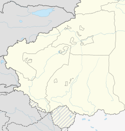 Oksalur Location of the township | |
| Coordinates: 39.6751364027°N 74.7914523316°E | |
| Country | People's Republic of China |
| Autonomous region | Xinjiang |
| Prefecture | Kizilsu |
| County | Ulugqat (Wuqia) |
| Seat | Qat Village (Qiati; 恰提村)[1][2][3] |
| Villages | 2 |
| Area | |
| • Total | 1,317 km2 (508 sq mi) |
| Population (2017)[4] | |
| • Total | 1,031 |
| • Density | 0.78/km2 (2.0/sq mi) |
| Ethnic groups | |
| • Major ethnic groups | Kyrgyz[1][5] |
| Time zone | UTC+8 (China Standard Time) |
| Website | www |
Oksalur Township is located 35 kilometers west of the county seat Wuqia Town. It is adjacent to Kiziloy Township in the east, Boritokay Township in the south and Ulugqat Township in the northwest, and borders with the Kyrgyz Republic in the west with a boundary line of 7 kilometers. There are 2 mountain passes and a river connecting with Kyrgyzstan.[4]
Name
The word Oksalur (ئوقسالۇر) comes from the Kyrgyz language, which means 'bullets in the chamber (of a gun)' or 'bullet in the bore (of a gun)'- Ok (ئوق), transliterated into Chinese characters as Wuhe (吾合) means 'bullet'. According to local tradition, there were numerous battles in this place, and the commanders ordered the locals' guns to be loaded with bullets.[1][2][5] The name Oksalur is transliterated into Chinese characters as Wuheshalu (吾合沙鲁). In Qing Dynasty maps of Shufu County, Oksalur is transliterated into Chinese characters as Wohusulu (倭胡素魯).[1][8]
History

Oksalur was part of the 2nd district of Wuqia County in 1950. Oksalur Commune (吾合沙鲁公社) was formed in 1958. In 1968 during the Cultural Revolution, the commune was renamed Weidong Commune (卫东公社). The original name was restored in 1980, and the commune was reorganized as a township in 1984.[2][5]
In early 2017, a security checkpoint was set up outside the door of the Oksalur Township border guard office.[9]
Geography
Oksalur is located on the northern bank of the Kezi River 35 km (22 mi) southwest of the county seat.[3][10] There is a scrubland along the Kezi River including many sea buckthorn.[1][8]
Settlements
The township has 2 administrative villages[11] and 3 unincorporated villages under its jurisdiction.[2][5]
- Qat[2] Village (Qiati, 恰提村) meaning 'fork in the road' or 'junction' (岔口)[1]
- Oksalur Village (ئوقسالۇر كەنت[7] / Wuheshalu,[10] 吾合沙鲁村)
- Maraltokay[2] (玛拉勒托阔依)
Demographics
| Year | Pop. | ±% p.a. |
|---|---|---|
| 2000 | 1,355 | — |
| 2010 | 1,029 | −2.71% |
| [12] | ||
As of 1997[update], the population of Kiziloy was 98% Kyrgyz.[5]
Economy
The economy of Oksalur is based on agriculture and animal husbandry.[1]
Transportation
Public roads to the north connect Oksalur to the road between Ulugqat Township and Artux.[1]
References
- Xie Yuzhong 解玉忠 (2003). 地名中的新疆 (in Simplified Chinese). Ürümqi: 新疆人民出版社. p. 195. ISBN 7-228-08004-1.
吾合沙鲁 Oksalur
- 乌恰县行政区划和居民地名称. xjwqx.gov.cn. 2018-06-04. Archived from the original on 2020-10-08. Retrieved 2019-10-19 – via Google Cache, Internet Archive.
- Zhong Xingqi 钟兴麒, ed. (July 2008). 西域地名考录 (in Simplified Chinese). Beijing: 国家图书馆出版社. p. 1010. ISBN 978-7-5013-3628-9.
- 吾合沙鲁乡简介 (in Simplified Chinese). xjwqx.gov.cn. 2018-05-30. Retrieved 2019-10-20.
- 1997年乌恰县行政区划 [1997 Ulugqat County Administrative Divisions] (in Simplified Chinese). XZQH.org. 31 December 2010. Archived from the original on 15 October 2017. Retrieved 10 October 2020.
吾合沙鲁乡 位于县城西南34.5千米。西部山区与吉尔吉斯斯坦接壤。面积1743平方千米,人口0.1万,其中柯尔克孜族占98%。未设行政村,只有3个村民小组。“吾合沙鲁”系柯尔克孜语译音,意为“子弹上膛”。因此地清代曾发生几次反侵略战争,每有外敌入侵,乡民即呼“子弹上膛”,以御外侮,因而得名。1950年为二区五乡,1958年成立吾合沙鲁公社,1968年更名卫东公社,1984年改设吾合沙鲁乡。地处克孜勒苏河畔盆地,水资源丰富。
- Mir Izzet Ullah (1843). "Travels beyond the Himalaya" (PDF). Journal of the Royal Asiatic Society. 7 (2): 321. JSTOR 25207596 – via JSTOR.
Oksalur
- ئامانگۈل ئابدۇراخمان, ed. (11 July 2019). ئاپتونوم رايون بويىچە نام بېرىلىدىغان، تەقدىرلىنىدىغان ئىككىنى ھىمايە قىلىشتىكى نەمۇنىلىك شەھەر (ناھىيە،رايون)، ئىككىنى ھىمايە قىلىشتىكى نەمۇنىلىك ئورۇن ۋە شەخسلەر ئىسىملىكى توغرىسىدىكى ئومۇمىي ئېلان. Tianshannet (in Uyghur). Archived from the original on 24 October 2020. Retrieved 24 October 2019.
ئوقسالۇر يېزىسى ئوقسالۇر كەنت
- Wen Hao 文昊, ed. (January 2007). 新疆地名与传说故事. 走进新疆丛书 (in Simplified Chinese). Ürümqi: 新疆美术摄影出版社, 新疆电子音像出版社. p. 46. ISBN 978-7-80744-012-3.
- 新疆乌恰县:崛起于帕米尔高原上的西部明珠 [Ulugqat County, Xinjiang: Shining Pearl of the West Rises on the Pamir Plateau]. Sina Corp (in Simplified Chinese). 29 September 2017. Archived from the original on 25 October 2020 – via Internet Archive.
今年初因工作需要,吾合沙鲁乡在边防派出所门口设立了一个执勤治安卡点。
- Xinwei Chen; Hanlin Chen; Edward R. Sobel; Xiubin Lin; Xiaogan Cheng; Jiakai Yan; Shaomei Yang (May 23, 2019). "Convergence of the Pamir and the South Tian Shan in the late Cenozoic: Insights from provenance analysis in the Wuheshalu section at the convergence area". Lithosphere. 11 (4). Retrieved 25 October 2020.
The Wuheshalu section is located ∼40 km west of Wuqia, between the PFT and the Wuheshalu fault in the convergence area between the Pamir and the South Tian Shan (Figs. 1, 2, and 4A). This ∼15-km-long section exposes late Cenozoic successions along the Kezilesu River southwest of the Wuheshalu Village, forming the south limb of an E-W–trending anticline (Fig. 1B and 1C).
{{cite journal}}: CS1 maint: uses authors parameter (link) - 2018年乌恰县吾合沙鲁乡行政区划代码. National Bureau of Statistics of China. 2018-10-31. Archived from the original on 11 October 2019. Retrieved 2019-10-20.
- 乌恰县历史沿革. XZQH.org (in Simplified Chinese). 29 January 2015. Archived from the original on 15 October 2017. Retrieved 5 October 2020.
2000年第五次人口普查,乌恰县常住总人口42002人,其中:{...}乌合沙鲁乡1355人、{...}2010年第六次人口普查,乌恰县常住总人口47261人,其中:{...}吾合沙鲁乡1029人,{...
}
Другой контент может иметь иную лицензию. Перед использованием материалов сайта WikiSort.org внимательно изучите правила лицензирования конкретных элементов наполнения сайта.
WikiSort.org - проект по пересортировке и дополнению контента Википедии