world.wikisort.org - China
Daba[1] (Tibetan: མདའ་པ, Wylie: mda' pa; Chinese: 达巴乡; pinyin: Dábā Xiāng) or Danbab[2] (Tibetan: མདའ་འབབ་ཤང, Wylie: mda' 'bab shang, ZYPY: Danbab Xang) is a township under the administration of Zanda County in the Tibet region of China, centred at the Daba village.[3]
Daba
མདའ་འབབ་ཤང | |
|---|---|
Township | |
| Danbab Township | |
 Daba Location in Tibet | |
| Coordinates: 31°13′44″N 79°55′29″E | |
| Country | People's Republic of China |
| Autonomous region | Tibet |
| Prefecture | Ngari Prefecture |
| County | Zanda County |
| Time zone | UTC+8 (China Standard) |
Geography
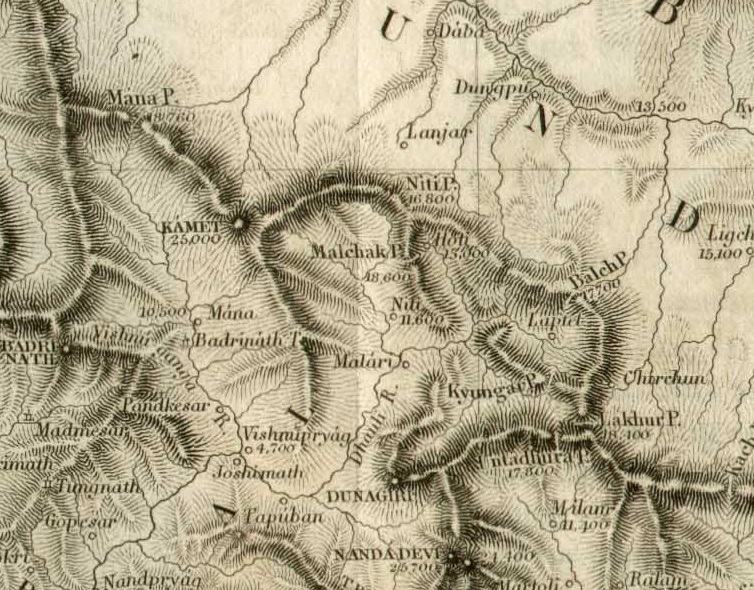
The Daba village is on the bank of the Daba Chu river, a tributary of the Sutlej River. The township of Daba spans both the banks of the Sutlej river, up to the Burang County and the Manasarovar region. It stretches to the south until the Indian border.
Daba village and township are close to the Indian border. On the Indian side of the border are Garhwal and Kumaon regions of India's Uttarakhand state. The Niti Pass and the Kungri Bingri Pass have served as the main historical trade routes. Since 1954, China has disputed the Indian control over the Barahoti region along the border.
As of 2020[update], the Daba township has two other villages in addition to Daba:[4][5]
- Dongbo Village (མདོང་པོ, 东波村)
- Kyunglung Village (ཁྱུང་ལུང, 曲龙村)
History
In the mid-19th century, Henry Strachey mentioned that Daba Dzong was one of the two dzongs in the Guge region of Ngari, the other being Tsaparang.[6] The Tibetan governor at Daba was called kharpön,[7] subordinate to the garpön stationed at Gartok. He was also referred to as Deba or Deva at other times.[8]
British explorer William Moorcroft travelled to Daba in 1812, via the Niti Pass and then proceeded to Gartok after receiving permission to do so.[9] The surveyor of Garhwal and Kumaon, W. J. Webb, met traders from Daba while surveying the vicinity of the Niti Pass in 1819. He offered to establish a trade mart for Daba traders on the Indian side but was told that it required a permission from the "viceroy of Lhasa".[10][11]
During the Dogra–Tibetan War, Zorawar Singh's forces occupied the Daba Dzong along with all other fortifications in Ngari.[12] They were eventually repulsed by the Tibetan forces and fled to Kumaon.
During 17th century, Fateh Shah of Garhwal invaded Tibet, where his sword and armour were preserved in the monastery at Daba for a long time. The ruler of Daba refused to pay its taxes to the Fateh Shah so Garhwal again conquered Daba .Some areas of Tibet accepted dominance of Pawar kings of Garhwal.[13][14][15]
References
- Strachey, Capt. H. (1853). "Physical Geography of Western Tibet". The Journal of the Royal Geographical Society. 23: 1–68. doi:10.2307/1797948. JSTOR 1797948.: "[Guge] contains at present two of the Tibetan dZong, one enthroned at Tsaprang on the Sutluj, in Guge Central and Proper, and the other at Daba in the south-eastern quarter."
- Ngari Precture, KNAB Place Name Database, retrieved 29 January 2022.
- 2020年统计用区划代码和城乡划分代码:札达县 (in Chinese). National Bureau of Statistics of the People's Republic of China. Retrieved 10 January 2021.
- 2020年统计用区划代码和城乡划分代码:达巴乡 (in Chinese). National Bureau of Statistics of the People's Republic of China. Retrieved 10 January 2021.
- "Ngari Prefecture". Institute of the Estonian Language. Retrieved 10 January 2021.
- Strachey, Capt. H. (1853). "Physical Geography of Western Tibet". The Journal of the Royal Geographical Society, Volume 23. Royal Geographical Society (Great Britain). p. 13.
- Lange, Diana (2020), An Atlas of the Himalayas by a 19th Century Tibetan Lama: A Journey of Discovery, BRILL, p. 295, ISBN 978-90-04-41688-8
- Moorcroft, William (1816), "A Journey to Lake Manasarovara in Un-Des, a Province of little Tibet", Asiatic Researches, XII: 449–450
- Denwood, Philip (1995), "William Moorcroft - An Assessment", in Henry Osmaston; Philip Denwood (eds.), Recent Research on Ladakh 4 & 5: Proceedings of the Fourth and Fifth International Colloquia on Ladakh, Motilal Banarsidass Publ., p. 41, ISBN 978-81-208-1404-2
- "Sur l'Elévation des Montagnes de l'Inde, par Alexandre de Humboldt" [On the Elevation of the Mountains of India], The Quarterly Review, London: John Murray: 416–430, 1820
- Marshall, Julie (2004), Britain and Tibet 1765–1947, Routledge, p. 145, ISBN 978-1-134-32784-3
- McKay, Alex (2003), History of Tibet, Volume 2: The Medieval Period: c.850-1895, Routledge, p. 28, ISBN 0-415-30843-7 – via archive.org
- Rawat, Ajay Singh (2002). Garhwal Himalayas: A Study in Historical Perspective. Indus Publishing. p. 50. ISBN 978-81-7387-136-8. OCLC 52088426.
- "Gharwal Ruler Fateh Shah's Silver Rupee". Mintage World. 2017-05-15. Retrieved 2022-08-27.
- RHODES, N. G. (1981). "The Silver Coinages of Garhwal and Ladakh, 1686-1871". The Numismatic Chronicle. 141: 120–135. ISSN 0078-2696. JSTOR 42667336.
External links
- Daba Township, OpenStreetMap, retrieved 29 January 2022.
Другой контент может иметь иную лицензию. Перед использованием материалов сайта WikiSort.org внимательно изучите правила лицензирования конкретных элементов наполнения сайта.
WikiSort.org - проект по пересортировке и дополнению контента Википедии