world.wikisort.org - Cape_Verde
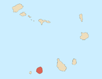
São Jorge is a settlement in the northern part of the island of Fogo, Cape Verde. It is situated near the coast, 2 km west of Campanas Baixo, 2 km northeast of Galinheiro and 15 km northeast of the island capital São Filipe.
São Jorge | |
|---|---|
Settlement | |
 São Jorge | |
| Coordinates: 15.013°N 24.430°W | |
| Country | Cape Verde |
| Island | Fogo |
| Municipality | São Filipe |
| Civil parish | São Lourenço |
| Population (2010)[1] | |
| • Total | 635 |
| ID | 82111 |
Sights


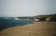
Ponta da Salina is a headland close to the village. There is a small natural harbour and a bay with basalt rock formations, one of which looks like a natural arch. There are some natural swimming pools and a dark sand beach where swimming is possible if the sea is not too rough.[2] There is a sightworthy old cemetery, which is surrounded by a wall, close to the beach.[3] Most of the graves have very simple wooden crosses without any names.
References
- "2010 Census results". Instituto Nacional de Estatística Cabo Verde (in Portuguese). 24 November 2016.
- Reitmaier, Pitt: Cabo Verde, p.391. Bielefeld 2009.
- Lipps, Susanne: Kapverdische Inseln, p.256. Ostfildern 2009.
Текст в блоке "Читать" взят с сайта "Википедия" и доступен по лицензии Creative Commons Attribution-ShareAlike; в отдельных случаях могут действовать дополнительные условия.
Другой контент может иметь иную лицензию. Перед использованием материалов сайта WikiSort.org внимательно изучите правила лицензирования конкретных элементов наполнения сайта.
Другой контент может иметь иную лицензию. Перед использованием материалов сайта WikiSort.org внимательно изучите правила лицензирования конкретных элементов наполнения сайта.
2019-2025
WikiSort.org - проект по пересортировке и дополнению контента Википедии
WikiSort.org - проект по пересортировке и дополнению контента Википедии
