world.wikisort.org - Cape_Verde
Cova Rodela is a village in the middle of the island of Brava, Cape Verde. The village is situated in the mountains, 1 km west of the island capital Nova Sintra. There are good walking paths to the island's tallest mountain Monte Fontainhas. Most of the inhabitants of the village live on agriculture, growing maize and bananas. In the main street there is a noteworthy old dragon tree (Dracaena draco). Cova Rodela can be reached easily by aluguer buses from Nova Sintra and from other villages on Brava.
Cova Rodela | |
|---|---|
Settlement | |
 Dragon Tree in Main Street. | |
 | |
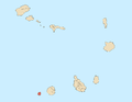
| Coordinates: 14.872°N 24.705°W | |
| Country | Cape Verde |
| Island | Brava |
| Municipality | Brava |
| Civil parish | São João Baptista |
| Population (2010)[1] | |
| • Total | 481 |
| ID | 91101 |


Many windows in Cova Rodela look similar to those which were common in New England in the 19th century.[2]
References
- "2010 Census results". Instituto Nacional de Estatística Cabo Verde (in Portuguese). 24 November 2016.
- Reitmaier, Pitt: Cabo Verde, p. 415. Bielefeld 2009.
The Island of Brava | ||
|---|---|---|
| Communities and settlements |
|  |
| Parishes |
| |
| Other geographical features |
| |
| Landmarks and points of interests |
| |
На других языках
[de] Cova Rodela
Cova Rodela ist ein Ort in der Mitte der Insel Brava, der westlichsten der Sotavento-Inseln (Inseln Unter dem Wind) von Kap Verde.- [en] Cova Rodela
Текст в блоке "Читать" взят с сайта "Википедия" и доступен по лицензии Creative Commons Attribution-ShareAlike; в отдельных случаях могут действовать дополнительные условия.
Другой контент может иметь иную лицензию. Перед использованием материалов сайта WikiSort.org внимательно изучите правила лицензирования конкретных элементов наполнения сайта.
Другой контент может иметь иную лицензию. Перед использованием материалов сайта WikiSort.org внимательно изучите правила лицензирования конкретных элементов наполнения сайта.
2019-2026
WikiSort.org - проект по пересортировке и дополнению контента Википедии
WikiSort.org - проект по пересортировке и дополнению контента Википедии