world.wikisort.org - Canada
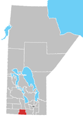
St. Lupicin is a locality within the Municipality of Lorne in south central Manitoba, Canada. It is located approximately 35 kilometers (22 miles) southwest of Carman, Manitoba.[1]
St. Lupicin | |
|---|---|
 St. Lupicin Roman Catholic Church | |
 St. Lupicin Location of St. Lupicin in Manitoba | |
| Coordinates: 49°27′31″N 98°28′35″W | |
| Country | |
| Province | |
| Region | Pembina Valley |
| Census Division | No. 4 |
| Government | |
| • Governing Body | Municipality of Lorne Council |
| • MP | Candice Bergen |
| • MLA | Blaine Pedersen |
| Time zone | UTC−6 (CST) |
| • Summer (DST) | UTC−5 (CDT) |
| Area code(s) | 204, 431 |
| NTS Map | 062G08 |
| GNBC Code | GAXYQ |
See also
- List of regions of Manitoba
- List of rural municipalities in Manitoba
References
- "Geographical Names of Canada - Querying Distances". nrcan.gc.ca. 2011-10-24. Retrieved 2012-09-30.
Текст в блоке "Читать" взят с сайта "Википедия" и доступен по лицензии Creative Commons Attribution-ShareAlike; в отдельных случаях могут действовать дополнительные условия.
Другой контент может иметь иную лицензию. Перед использованием материалов сайта WikiSort.org внимательно изучите правила лицензирования конкретных элементов наполнения сайта.
Другой контент может иметь иную лицензию. Перед использованием материалов сайта WikiSort.org внимательно изучите правила лицензирования конкретных элементов наполнения сайта.
2019-2025
WikiSort.org - проект по пересортировке и дополнению контента Википедии
WikiSort.org - проект по пересортировке и дополнению контента Википедии
