world.wikisort.org - Canada
Saumarez is a civil parish in Gloucester County, New Brunswick, Canada.[2]
Saumarez | |
|---|---|
Parish | |
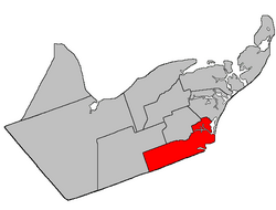 Location within Gloucester County, New Brunswick map erroneously shows pre-1896 boundaries | |
| Coordinates: 47.5°N 64.94°W | |
| Country | |
| Province | |
| County | Gloucester |
| Erected | 1814 |
| Area | |
| • Land | 326.78 km2 (126.17 sq mi) |
| Population (2016)[1] | |
| • Total | 6,818 |
| • Density | 20.9/km2 (54/sq mi) |
| • Change 2011-2016 | |
| • Dwellings | 3,111 |
| Time zone | UTC-4 (AST) |
| • Summer (DST) | UTC-3 (ADT) |
| Figures do not include portion within regional municipality of Tracadie No census data available after 2016 | |
Before the formation of the Regional Municipality of Grand Tracadie-Sheila in 2014, Saumarez Parish was subdivided into one town and twelve local service districts, with an additional special service area within the parish LSD.
Tracadie is a member of the Acadian Peninsula Regional Service Commission (APRSC).[3]
Origin of name
The parish was named in honour of Sir Thomas Saumarez, acting Governor of New Brunswick when it was erected.[4] Six of the parishes erected simultaneously in Northumberland County in 1814[5] were named for prominent British military figures.
History
Saumarez was erected in 1814 as part of Northumberland County from unassigned territory.[5] It included most of modern Gloucester County.
In 1827 Bathurst was erected as its own parish.[6]
In 1831 Caraquet and New Bandon were erected as their own parishes.[7]
In 1855 Inkerman was erected from the northern part of Saumarez.[8]
In 1870 the boundary with Inkerman was adjusted.[9]
In 1881 Saint-Isidore Parish included part of Saumarez[10]
In 1947 part of Saumarez was included in the newly erected Allardville.[11]
Boundaries
Saumarez Parish is bounded:[2][12][13]
- on the east by LeBouthillier Brook, the Old Tracadie Gully, and the Gulf of Saint Lawrence;
- on the south by the Northumberland County line;
- on the west by the western line of timber block 4 in Ranges 8, 9, 10, the southernmost corner of Range 10 being downstream of the mouth of Bear Brook and upstream of the mouth of Big Hole Brook;
- on the north by the prolongation of the southern line of Range 9 in the Saint Isidore Settlement, which runs along the south side of Rang 9 Road, northeasterly to the Little Tracadie River, then downstream until it strikes Range 9 again, then northeasterly along Range 9 to its easternmost corner, then northwesterly along the eastern line of Ranges 9, 8 (partly along Alderwood Road), and 7 to the rear line of Range 6 of Saint Isidore, which runs along the south side of Route 160, then northeasterly along Range 6 to its easternmost corner, then northwesterly to the sharp bend of Boishébert Road, then northeasterly along grant lines to Gaspereau Creek, then upstream two grants to the southern line of Route 160 and the W. Gautreau Road, then northeasterly to the Saint-Raymond Road, then northwesterly across two grants to the northern line of the second grant, then northeasterly along the grant line and its prolongation to where Route 11 crosses LeBouthillier Brook.
Governance
The entire parish is part of the Regional Municipality of Tracadie.
Communities
Communities at least partly within the parish.[12][13][14] italics indicate a name no longer in official use
- Alderwood
- Benoit
- Gauvreau
- Leech
- Little Gaspereau
- Little Tracadie
- Losier Settlement
- Pointe-à-Bouleau
- Pont-Lafrance
- Pont-Landry
- Rivière-à-la-Truite (Trout Stream)
- Saint-Irénée
- Saint-Pons
- Saumarez
- Tracadie Beach
- Tracadie-Sheila
- Upper Sheila
- Val-Comeau
Bodies of water
Bodies of water[lower-alpha 1] at least partly within the parish.[12][13][14]
- Rivière à Comeau
- Big Tracadie River
- Leech River
- Little Tracadie River
- Tabusintac River
- Odilon Stream
- Trout Stream
- Gulf of St. Lawrence
- Tracadie Bay
- Big Tracadie River Gully
- Old Tracadie Gully
- Tracadie Gully
- The Lake
Conservation areas
Parks, historic sites, and related entities at least partly within the parish.[12][13][14][15]
- Val-Comeau Provincial Park
Demographics
Population
| 2016 | 2011 | |
|---|---|---|
| Population | 6,818 (-1.5% from 2011) | 6,920 (+1.3% from 2006) |
| Land area | 326.78 km2 (126.17 sq mi) | 326.78 km2 (126.17 sq mi) |
| Population density | 20.9/km2 (54/sq mi) | 21.2/km2 (55/sq mi) |
| Median age | 49.2 (M: 48.5, F: 49.8) | 45.9 (M: 45.5, F: 46.3) |
| Total private dwellings | 3,111 | 3,016 |
| Median household income | $56,029 | $47,379 |
|
|
| ||||||||||||||||||||||||||||||
(A) adjustment due to boundary change [20][21][1] | ||||||||||||||||||||||||||||||||
Language
| Canada Census Mother Tongue - Saumarez Parish, New Brunswick[20] | ||||||||||||||||||
|---|---|---|---|---|---|---|---|---|---|---|---|---|---|---|---|---|---|---|
| Census | Total | French |
English |
French & English |
Other | |||||||||||||
| Year | Responses | Count | Trend | Pop % | Count | Trend | Pop % | Count | Trend | Pop % | Count | Trend | Pop % | |||||
2011 |
6,870 |
6,695 | 97.45% | 125 | 1.82% | 45 | 0.65% | 5 | 0.08% | |||||||||
2006 |
6,805 |
6,610 | 97.13% | 140 | 2.06% | 25 | 0.37% | 30 | 0.44% | |||||||||
2001 |
6,935 |
6,830 | 98.49% | 75 | 1.08% | 30 | 0.43% | 0 | 0.00% | |||||||||
1996 |
7,370 |
7,150 | n/a | 97.02% | 180 | n/a | 2.44% | 40 | n/a | 0.54% | 0 | n/a | 0.00% | |||||
See also
- List of parishes in New Brunswick
Notes
- Not including brooks, ponds or coves.
References
- "Census Profile, 2016 Census: Saumarez, Parish [Dissolved census subdivision], New Brunswick". Statistics Canada. Retrieved 8 September 2019.
- "Chapter T-3 Territorial Division Act". Government of New Brunswick. Retrieved 13 November 2020.
- "Communities in each of the 12 Regional Service Commissions (RSC) / Les communautés dans chacune des 12 Commissions de services régionaux (CSR)" (PDF), Government of New Brunswick, July 2017, retrieved 2 February 2021
- Ganong, William F. (1896). A Monograph of the Place-Nomenclature of the Province of New Brunswick. Royal Society of Canada. p. 271. Retrieved 17 March 2021.
- "54 Geo. III c. 17 An Act in further addition to an Act, intituled 'An Act for the better ascertaining and confirming the boundaries of the several Counties, within this Province, and for subdividing them into Towns or Parishes.'". Acts of the General Assembly of His Majesty's Province of New-Brunswick; Passed in the Year 1814. Saint John, New Brunswick: Government of New Brunswick. 1814. pp. 16–18. Retrieved 27 March 2021.
- "7 Geo. IV c. 31 An Act for the division of the County of Northumberland into three Counties, and to provide for the Government and Representation of the two new Counties.". Acts of the General Assembly of His Majesty's Province of New-Brunswick, Passed in the Year 1827. Fredericton: Government of New Brunswick. 1827. pp. 97–103. Retrieved 27 March 2021.
- "1 Wm. IV c. 19 An Act to erect Two new Parishes in the County of Gloucester.". Acts of the General Assembly of His Majesty's Province of New-Brunswick, Passed in the Year 1831. Fredericton: Government of New Brunswick. 1831. pp. 68–69. Retrieved 27 March 2021.
- "18 Vic. c. 47 An Act for dividing the Parish of Saumarez, in the County of Gloucester, into two separate Parishes.". Acts of the General Assembly of Her Majesty's Province of New Brunswick, Passed in the Month of November, 1854, and in the Months of February, March, and April, 1855. Fredericton: Government of New Brunswick. 1855. pp. 176–177. Available as a free ebook from Google Books.
- "33 Vic. c. 11 An Act to alter the Division Line between the Parishes of Saumarez and Inkerman, in the County of Gloucester.". Acts of the General Assembly of Her Majesty's Province of New Brunswick Passed in the Months of March & April 1870. Fredericton: Government of New Brunswick. 1870. p. 20. Available as a free ebook from Google Books.
- "44 Vic. c. 34 An Act to erect part of the Parishes of Saumarez and Inkerman, in the County of Gloucester, into a separate Parish.". Acts of the General Assembly of Her Majesty's Province of New Brunswick. Passed in the Month of March 1881. Fredericton: Government of New Brunswick. 1881. pp. 70–72. Available as a free ebook from Google Books.
- "10 Geo. VI. c. 90 An Act to amend the Act respecting the division of the Province into Counties, Towns and Parishes, in so far as it relates to the County of Gloucester". Acts of the Legislative Assembly of New Brunswick Passed During the Session of 1946. Fredericton: Government of New Brunswick. 1946. pp. 301–309.
- "No. 30". Provincial Archives of New Brunswick. Department of Natural Resources and Energy Development. Retrieved 8 June 2021. Remainder of parish on maps 42 and 43 at same site.
- "094" (PDF). Transportation and Infrastructure. Government of New Brunswick. Retrieved 8 June 2021. Remainder of parish on mapbooks 095, 113–115, 135, and 136 at same site.
- "Search the Canadian Geographical Names Database (CGNDB)". Government of Canada. Retrieved 5 July 2021.
- "New Brunswick Regulation 2017-46 under the Parks Act (O.C. 2017-293)" (PDF). The Royal Gazette. Fredericton: Queen's Printer. 175: 1496–1497. 13 December 2017. ISSN 1714-9428. Retrieved 5 July 2021.
- "2016 Community Profiles". 2016 Canadian Census. Statistics Canada. 12 August 2021. Retrieved 8 September 2019.
- "2011 Community Profiles". 2011 Canadian Census. Statistics Canada. 21 March 2019. Retrieved 30 March 2014.
- "2006 Community Profiles". 2006 Canadian Census. Statistics Canada. 20 August 2019.
- "2001 Community Profiles". 2001 Canadian Census. Statistics Canada. 18 July 2021.
- Statistics Canada: 1996, 2001, 2006, 2011 census
- 2011 Statistics Canada Census Profile: Saumarez Parish, New Brunswick
Places adjacent to Saumarez Parish, New Brunswick | ||||||||||||||||
|---|---|---|---|---|---|---|---|---|---|---|---|---|---|---|---|---|
| ||||||||||||||||
Subdivisions of New Brunswick | |
|---|---|
| Subdivisions |
|
| Cities | |
| Counties | |
| |
Другой контент может иметь иную лицензию. Перед использованием материалов сайта WikiSort.org внимательно изучите правила лицензирования конкретных элементов наполнения сайта.
WikiSort.org - проект по пересортировке и дополнению контента Википедии