world.wikisort.org - Canada
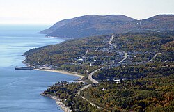
Saint-Siméon is a municipality in the Charlevoix-Est Regional County Municipality of Quebec, Canada. Founded in 1869, it was named after Saint Simeon of Jerusalem.
Saint-Siméon | |
|---|---|
Municipality | |
 | |
 Location within Charlevoix-Est RCM | |
 Saint-Siméon Location in central Quebec | |
| Coordinates: 47°50′N 69°53′W[1] | |
| Country | Canada |
| Province | Quebec |
| Region | Capitale-Nationale |
| RCM | Charlevoix-Est |
| Constituted | April 25, 2001 |
| Government | |
| • Mayor | Sylvain Tremblay |
| • Federal riding | Montmorency—Charlevoix —Haute-Côte-Nord |
| • Prov. riding | Charlevoix–Côte-de-Beaupré |
| Area | |
| • Total | 412.30 km2 (159.19 sq mi) |
| • Land | 283.92 km2 (109.62 sq mi) |
| Population (2011)[3] | |
| • Total | 1,300 |
| • Density | 4.6/km2 (12/sq mi) |
| • Pop 2006-2011 | |
| • Dwellings | 702 |
| Time zone | UTC−5 (EST) |
| • Summer (DST) | UTC−4 (EDT) |
| Postal code(s) | G0T 1X0 |
| Area code(s) | 418 and 581 |
| Highways | |
| Website | www |
Its population centres include Saint-Siméon, Baie-des-Rochers, Port-au-Persil, and Port-aux-Quilles, all located along Route 138.
History
The municipality was formed as a parish municipality in 1869 when it was separated from Saint-Fidèle-de-Mont-Murray (now part of La Malbaie). Its post office opened in 1882. In 1911, the main village was separated from the parish municipality and incorporated as the Village Municipality of Saint-Siméon. In 2001, the two municipal entities were rejoined as the new Municipality of Saint-Siméon.[1]
Demographics
Population
Population trend:[4]
- Population in 2011: 1300 (2006 to 2011 population change: -4.4%)
- Population in 2006: 1360
- Population total in 2001: 1452
- Saint-Siméon (parish): 468
- Saint-Siméon (village): 984
- Population in 1996:
- Saint-Siméon (parish): 477
- Saint-Siméon (village): 1012
- Population in 1991:
- Saint-Siméon (parish): 519
- Saint-Siméon (village): 1020
Private dwellings occupied by usual residents: 551 (total dwellings: 702)
Language
Mother tongue:
- English as first language: 0%
- French as first language: 100%
- English and French as first language: 0%
- Other as first language: 0%
See also
- List of municipalities in Quebec
References
- "Saint-Siméon (Municipalité)" (in French). Commission de toponymie du Québec. Retrieved 2010-05-25.
- Ministère des Affaires municipales, des Régions et de l'Occupation du territoire - Répertoire des municipalités: Saint-Siméon
- Statistics Canada 2011 Census - Saint-Siméon
- Statistics Canada: 1996, 2001, 2006, 2011 census
External links
![]() Media related to Saint-Siméon, Capitale-Nationale, Quebec at Wikimedia Commons
Media related to Saint-Siméon, Capitale-Nationale, Quebec at Wikimedia Commons
Другой контент может иметь иную лицензию. Перед использованием материалов сайта WikiSort.org внимательно изучите правила лицензирования конкретных элементов наполнения сайта.
WikiSort.org - проект по пересортировке и дополнению контента Википедии

