world.wikisort.org - Canada
Moosonee (/ˌmuːsəˈniː/) is a town in northern Ontario, Canada, on the Moose River approximately 19 km (12 mi) south of James Bay. It is considered to be "the Gateway to the Arctic" and has Ontario's only saltwater port.[4] Nearby on Moose Factory Island is the community of Moose Factory to which it is connected by water taxi in the summer and ice road in the winter.
Moosonee | |
|---|---|
Town (single-tier) | |
| Town of Moosonee | |
 | |
|
| |
 Moosonee  Moosonee | |
| Coordinates: 51°20′03″N 80°43′16″W[1] | |
| Country | Canada |
| Province | Ontario |
| Region | Northeastern Ontario |
| District | Cochrane |
| Settled | 1903 |
| Incorporated | 2001 |
| Government | |
| • Mayor | Wayne Taipale |
| • Councillors | List |
| • MP | Charlie Angus |
| • MPP | Guy Bourgouin |
| Area | |
| • Land | 546.72 km2 (211.09 sq mi) |
| Population (2016)[3] | |
| • Total | 1,481 |
| • Density | 2.7/km2 (7/sq mi) |
| Time zone | UTC−05:00 (EST) |
| • Summer (DST) | UTC−04:00 (EDT) |
| Postal code | P0L 1Y0 |
| Area code | 705 |
| Website | www.moosonee.ca |
There is no road connection to the community but flights are provided by Air Creebec and by Thunder Airlines.[5] Moosonee is also the railhead of the Ontario Northland Railway where goods are transferred to barges and aircraft for transport to more northerly communities. Moosonee is not particularly far north, being located at 51°N—which is roughly the same latitude as Saskatoon, Calgary, London (UK), and Berlin—but is colder due to its proximity to Hudson Bay, and isolated due to its lack of road access to the rest of Ontario. The community was the site of a fur trading post set up in 1903 by Revillon Frères, competitors to the Hudson's Bay Company which later bought out Révillon.
Moosonee formerly held the status of a development area, the only community in the province with that designation, and was governed by a locally elected board subject to formal appointment by the Ontario provincial government. It became incorporated as a town effective January 1, 2001, with an elected mayor and four-person council.
History

In 1900, Annie Hardisty and her two daughters were the first settlers on the site.[6] Significant development began on June 6, 1903, four canoes and a crew of 21 persons of the Révillon Frères company arrived on the banks of the Moose River near the much older Moose Factory to establish the Moose River Post. This Parisian furrier had ambitious plans to set up a chain of fur trading posts in direct competition with the Hudson's Bay Company, including five on James Bay. But it suffered a setback when their supply ship that carried all the provisions shipwrecked near Fort George.[7] The Revillon Frères Museum is located on First Street.
Moose River Post became the most important location for Révillon Frères and was quickly expanded with a staff house, carpenter's shop, warehouse, and sawmill. The buildings were spaced far apart as a preventive measure to minimize the spread of fire. By 1912, it was reported that "the whole line of good substantial buildings, built principally for their French Canadian employees, stretches along the river front for nearly a mile northward from the residence of the inspector."[7]
Moose River Post (and Moose Factory) were prosperous but isolated. It was supplied only once per year by ship coming from Montreal around the Labrador Peninsula. Mail arrived only four times per year, twice by canoe and twice by toboggan. During World War I, Révillon Frères' chartered supply ship was requisitioned for war service. So from then on until 1932, the post was supplied by scows from Pagwa on the National Transcontinental Railway coming down the Pagwachuan, Kenogami, and Albany Rivers.[7]
In 1932, the Temiskaming and Northern Ontario Railway was extended from Cochrane to Moose River Post, that was renamed at that time to Moosonee, derived from the Cree word môsonihk meaning "at the Moose [River]". In 1936, Révillon Frères sold its Canadian operations to the Hudson's Bay Company and the Moosonee post closed.[4][7] The HBC also exited the fur trade and opened a retail store in Moosonee (now Northern Store part of The North West Company). With the end of the fur trade business, Moosonee's economy became centred on transportation.[8]
In 1962, Moosonee became the site of RCAF Station Moosonee that was part of NORAD's Pinetree Line chain of radar stations. It closed in 1975 and some of its buildings were used by the Town after the closure, including the base swimming pool and recreation centre.[9]
In 1968, the town was classified as a development area board. In November 2000, it was incorporated as the Town of Moosonee.[4]
The most recent municipal council was elected on October 27, 2014, and three replacement councillors were elected in a by-election held on July 7, 2015.[needs update] For 2014–2018, the town council consisted of mayor Wayne Taipale, and councillors Tony Tourville, John Moore, Carman Tozer and Cathy Turner.[10]
Demographics
| Year | Pop. | ±% |
|---|---|---|
| 1981 | 1,433 | — |
| 1986 | 1,319 | −8.0% |
| 1991 | 1,213 | −8.0% |
| 1996 | 1,939 | +59.9% |
| 2001 | 1,916 | −1.2% |
| 2006 | 2,006 | +4.7% |
| 2011 | 1,725 | −14.0% |
| 2016 | 1,481 | −14.1% |
| [11][12] | ||
In the 2021 Census of Population conducted by Statistics Canada, Moosonee had a population of 1,512 living in 487 of its 629 total private dwellings, a change of 2.1% from its 2016 population of 1,481. With a land area of 547.83 km2 (211.52 sq mi), it had a population density of 2.8/km2 (7.1/sq mi) in 2021.[13]
In 2011, mother tongue was 79.3% English, 17.7% Cree, 1.8% French, and 1.2% other language.[14]
| 2021 | 2016 | 2011 | |
|---|---|---|---|
| Population | 1,512 (+2.1% from 2016) | 1,481 (-14.1% from 2011) | 1,725 (-14.0% from 2006) |
| Land area | 547.83 km2 (211.52 sq mi) | 546.72 km2 (211.09 sq mi) | 550.12 km2 (212.40 sq mi) |
| Population density | 2.8/km2 (7.3/sq mi) | 2.7/km2 (7.0/sq mi) | 3.1/km2 (8.0/sq mi) |
| Median age | 29.8 (M: 28.8, F: 30.6) | 28.1 (M: 26.9, F: 29.1) | 27.6 (M: 27.2, F: 27.9) |
| Total private dwellings | 490 | 633 | 635 |
| Median household income | $73,370 |
Services
Moosonee has two elementary schools, Moosonee Public School and Bishop Belleau Separate School (Roman Catholic) that offer kindergarten through grade eight. Bishop Belleau School also provides a French Language Instructional Unit for children who are entitled to be educated in French. There is a public high school, Northern Lights Secondary School, that provides grades nine through twelve. Northern College's Moosonee campus provides some post-secondary programs.
Health services are provided through the Moosonee Health Clinic of the Weeneebayko Area Health Authority (merger of the former James Bay General Hospital and the Weeneebayko Health Ahtuskaywin which operated Weeneebayko General Hospital in Moose Factory).
Payukotayno (pronounced pay-k-ta-no) Family Services provide child care and social assistance to Moosonee, Moose Factory, Attawapiskat First Nation, Fort Albany, Kashechewan and Peawanuck. Payukotayno is a recognized Ontario Children's Aid Society and means 'one family' in Cree.
As of 2020 a "satellite Trades Centre" was being operated in the community by Northern College "linked to the ... Timmins Campus"; courses included technology, trades and apprenticeship programs.[20]
Climate
Moosonee has a humid continental climate (Köppen climate classification Dfb) with subarctic influences, which gives the town warm summers and cold winters, sometimes severe. James Bay acts as a thermal reservoir to moderate spring and fall temperatures. Freeze-up on the Moose River normally occurs between late November and mid-December, with mean daily minimum January temperatures approximately −27 °C (−17 °F). Spring break-up, or spring thaw, usually occurs in April. Mean annual precipitation is approximately 682 mm (26.9 in), and mean annual snowfall is approximately 213 cm (84 in). Precipitation is somewhat higher in summer than at other times of the year. Severe thunderstorms can occur from time to time. Moosonee used to have a subarctic climate with a yearly mean temperature of −1.3 °C (29.7 °F), but due to global warming that temperature has risen.[21]
The highest temperature ever recorded in Moosonee was 37.8 °C (100.0 °F) on 31 July 1975.[22] The coldest temperature ever recorded was −48.9 °C (−56.0 °F) on 24 January 1935.[23]
| Climate data for Moosonee, 1981–2010 normals, extremes 1877–present[lower-alpha 1] | |||||||||||||
|---|---|---|---|---|---|---|---|---|---|---|---|---|---|
| Month | Jan | Feb | Mar | Apr | May | Jun | Jul | Aug | Sep | Oct | Nov | Dec | Year |
| Record high humidex | 7.2 | 8.9 | 26.6 | 29.6 | 36.8 | 39.3 | 44.7 | 43.4 | 40.8 | 28.8 | 20.7 | 12.9 | 44.7 |
| Record high °C (°F) | 7.2 (45.0) |
10.6 (51.1) |
25.0 (77.0) |
29.0 (84.2) |
35.0 (95.0) |
37.5 (99.5) |
37.8 (100.0) |
35.6 (96.1) |
32.8 (91.0) |
29.0 (84.2) |
20.5 (68.9) |
13.2 (55.8) |
37.8 (100.0) |
| Average high °C (°F) | −13.6 (7.5) |
−10.5 (13.1) |
−3.9 (25.0) |
4.3 (39.7) |
13.3 (55.9) |
19.1 (66.4) |
22.6 (72.7) |
21.1 (70.0) |
15.7 (60.3) |
7.9 (46.2) |
−0.5 (31.1) |
−9.3 (15.3) |
5.5 (41.9) |
| Daily mean °C (°F) | −20.0 (−4.0) |
−17.5 (0.5) |
−11.1 (12.0) |
−1.8 (28.8) |
6.8 (44.2) |
12.2 (54.0) |
15.8 (60.4) |
14.9 (58.8) |
10.5 (50.9) |
3.8 (38.8) |
−4.3 (24.3) |
−14.5 (5.9) |
−0.5 (31.1) |
| Average low °C (°F) | −26.3 (−15.3) |
−24.6 (−12.3) |
−18.3 (−0.9) |
−7.9 (17.8) |
0.2 (32.4) |
5.3 (41.5) |
8.9 (48.0) |
8.6 (47.5) |
5.2 (41.4) |
−0.5 (31.1) |
−8.2 (17.2) |
−19.7 (−3.5) |
−6.4 (20.5) |
| Record low °C (°F) | −48.9 (−56.0) |
−47.8 (−54.0) |
−44.4 (−47.9) |
−33.9 (−29.0) |
−17.8 (0.0) |
−7.0 (19.4) |
−2.2 (28.0) |
−3.1 (26.4) |
−6.1 (21.0) |
−16.7 (1.9) |
−34.4 (−29.9) |
−44.4 (−47.9) |
−48.9 (−56.0) |
| Record low wind chill | −56 | −53 | −49 | −37 | −26 | −10 | −4 | −5 | −10 | −20 | −40 | −51 | −56 |
| Average precipitation mm (inches) | 33.0 (1.30) |
28.6 (1.13) |
35.3 (1.39) |
38.1 (1.50) |
54.6 (2.15) |
71.7 (2.82) |
96.8 (3.81) |
77.8 (3.06) |
95.3 (3.75) |
74.7 (2.94) |
56.3 (2.22) |
41.5 (1.63) |
703.6 (27.70) |
| Average rainfall mm (inches) | 0.1 (0.00) |
1.8 (0.07) |
6.5 (0.26) |
21.0 (0.83) |
47.7 (1.88) |
71.5 (2.81) |
96.8 (3.81) |
77.8 (3.06) |
94.6 (3.72) |
62.1 (2.44) |
19.1 (0.75) |
3.5 (0.14) |
502.6 (19.79) |
| Average snowfall cm (inches) | 39.9 (15.7) |
31.7 (12.5) |
31.0 (12.2) |
17.9 (7.0) |
6.6 (2.6) |
0.2 (0.1) |
0.0 (0.0) |
0.0 (0.0) |
0.6 (0.2) |
13.2 (5.2) |
40.6 (16.0) |
45.2 (17.8) |
226.8 (89.3) |
| Average precipitation days (≥ 0.2 mm) | 14.8 | 11.3 | 10.9 | 10.2 | 12.5 | 13.9 | 16.4 | 15.2 | 18.5 | 16.5 | 15.7 | 15.9 | 171.7 |
| Average rainy days (≥ 0.2 mm) | 0.23 | 0.95 | 2.2 | 5.1 | 10.8 | 13.8 | 16.4 | 15.2 | 18.5 | 13.4 | 4.8 | 1.1 | 102.3 |
| Average snowy days (≥ 0.2 cm) | 15.0 | 11.0 | 10.1 | 6.7 | 3.1 | 0.17 | 0.0 | 0.0 | 0.09 | 5.0 | 13.1 | 15.6 | 79.7 |
| Mean monthly sunshine hours | 93.6 | 128.7 | 161.6 | 192.0 | 221.2 | 213.5 | 249.2 | 219.7 | 134.8 | 88.5 | 52.9 | 55.2 | 1,810.7 |
| Percent possible sunshine | 35.8 | 45.7 | 44.0 | 46.3 | 45.9 | 43.1 | 50.0 | 48.6 | 35.4 | 26.6 | 19.7 | 22.3 | 38.6 |
| Source: Environment Canada[22][24][25][26][27] | |||||||||||||
Transportation
The town is billed as "a major transportation hub for Ontario’s Far North".[28]
As of 2020, the MV Niska 1 ferry was operating between Moosonee and Moose Factory island, carrying passengers and vehicles.[29]
Moosonee Station and Yard
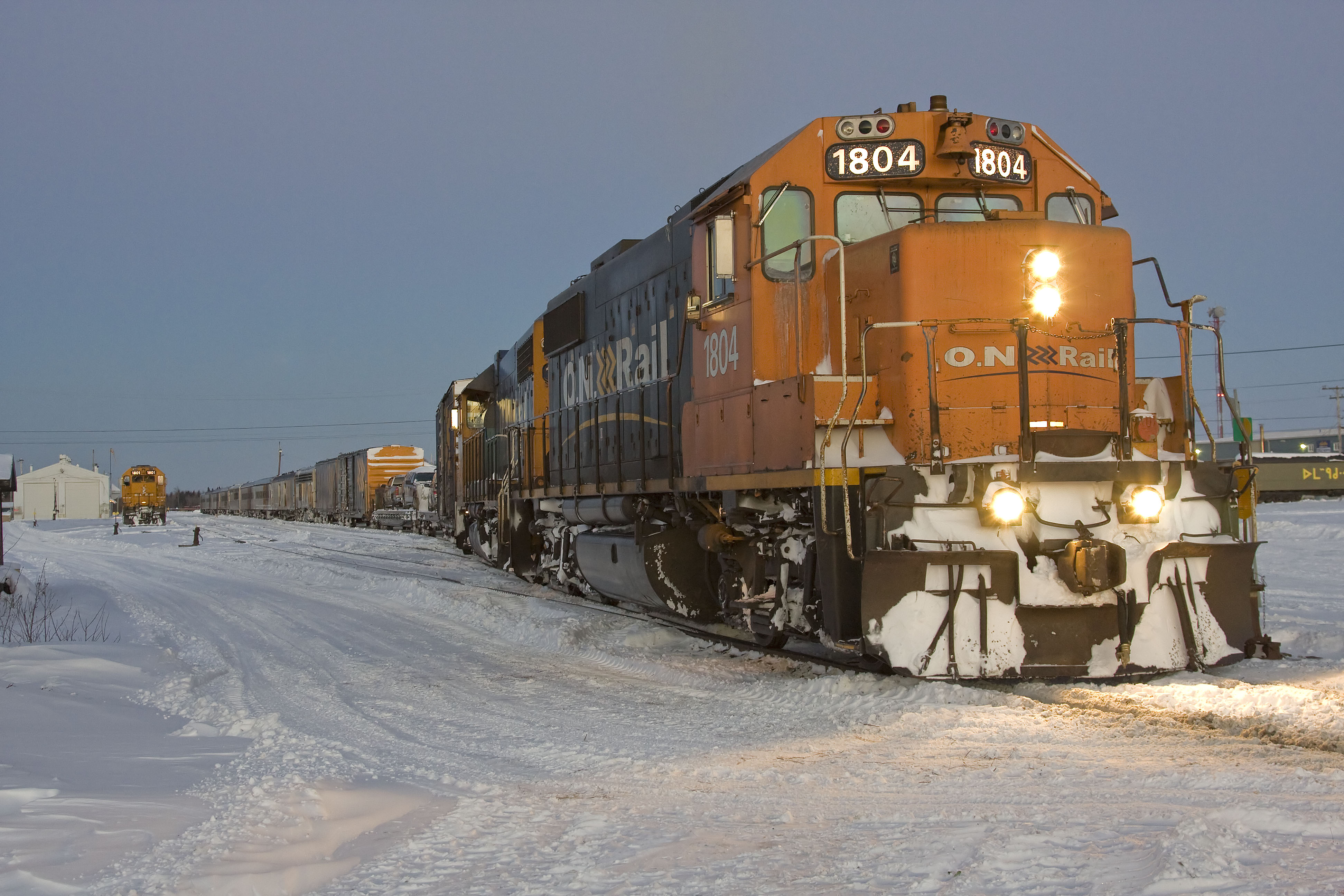
The main method of access is by Ontario Northland Railway which reached the town in 1932 and which provides passenger and freight train service to Cochrane.[8] Ontario Northland's Polar Bear Express train runs from Moosonee station to Cochrane six days per week during the summer months and five days per week during the rest of the year. Moosonee Station is located at the end of First Street and has a small station building, freight shed, diesel shed and an outdoor yard to store trains. Tickets are sold by phone or at the offices Cochrane, Ontario, Moosonee, Moose Factory and Timmins. The train will stop on demand in some locations as part of the flag stop service.[30] No meal service is available on this train.[31]
There are also two freight trains per week. During the summer and early fall shipping season, goods can be transported from Moosonee by barge. In January 2007, responsibility for the Port of Moosonee was transferred from the federal government to the Town of Moosonee. The Polar Bear Express Passenger Train transports cars, canoes, ATVs, and snowmobiles as long as they are booked in advance notice. It is one of only two motorail services in North America.
Airport
The town is also accessible via the Moosonee Airport, served with scheduled flights of Air Creebec, Moosonee Water Aerodrome and cargo service through North Star Air.
Roads
Moosonee is inaccessible by road. The nearest road outside of Moosonee ends at Otter Rapids which is 148.9 km (92.5 mi) south of Moosonee. During the early months of 2008, a winter road was open between Moosonee and the provincial road system at Otter Rapids. This road was built to support the twinning of the electric transmission lines that run from Otter Rapids to Moosonee. Local residents report it taking five or six hours to get to Timmins from Moosonee via Otter Rapids and Smooth Rock Falls. This road was not in service in 2009. In late 2009, members of the Moose Cree First Nation voted for the construction of a seasonal winter road south to Otter Rapids.
During the winter, ice roads are plowed and maintained on the ice across the Moose River to Moose Factory and winter roads are maintained to the coastal communities of Fort Albany, Kashechewan and Attawapiskat. In recent years, much of the traffic heading up north has been destined for the Victor Diamond Mine operated by De Beers Canada to the west of Attawapiskat.
In January 2021, the 311 km (193 mi) James Bay Winter Ice Road was under construction, to connect Attawapiskat, Kashechewan, Fort Albany and Moosonee.[32] It opened some time in winter 2021 and was said to accept loads up to 50,000 kilograms in weight. The road was operated by Kimesskanemenow LP, "a limited partnership between the four communities it connects".[33]
Feasibility studies have been undertaken on the construction of a permanent all-season road to the communities of Moosonee, Fort Albany, Kashechewan and Attawapiskat River.[34] The project, if undertaken, will entail a "coastal road" connecting the four communities with each other, as well as a road to link the coastal road to the provincial highway system at Fraserdale, Kapuskasing or Hearst.[35]
Communications
Moosonee has a local radio station, CHMO 1450 AM, that is generally operated by volunteers, plus a rebroadcasting facility for CBC Radio One Northern Ontario from CBCS-FM Sudbury on 1340 AM. Most homes subscribe to either Creecable cable TV or a satellite TV service to receive their programming, following the 2012 closure of the local CBC Television and TVOntario repeaters.
Ontera, formerly Ontario Northland Telecommunications, but now owned by Bell, provides telecommunications service in Moosonee (NPA-NXX 705-336).
Attractions and tourism
Tourism agencies recommend the Polar Bear Express as a "great rail excursion" in summer, between Cochrane and Moosonee, to view the "hydroelectric dams, isolated homes and perhaps even some wildlife."[36] No meal service is available on this train.[31]
A private company offers freighter-canoe ferry across the Moose River to Moose Factory where Centennial Park exhibits 19th-century buildings from the fur-trading era.[37]
Notable attractions in Moosonee include:
- Railway Car Museum – displaying the cultural history of the area in an old Baggage Car of the Temiskaming & Northern Ontario Railway.
- MNR Interpretive Centre – displays and videos at the office of the Ministry of Natural Resources highlighting the wildlife, geological, and geographical features of the region.
- Excursions to the bird sanctuaries of Shipsands Island and the Southern James Bay.
The Tidewater Provincial Park is on nearby Charles Island, adjacent to Moose Factory Island.
References
- "Moosonee". Geographical Names Data Base. Natural Resources Canada.
- "Moosonee". Geographical Names Data Base. Natural Resources Canada.
- "Census Profile, 2016 Census: Moosonee, Town". Statistics Canada. Retrieved February 14, 2019.
- "About Ontario: Moosonee". Queen's Printer for Ontario. Retrieved 2010-12-22.
- "TOWN OF MOOSONEE". Retrieved 15 March 2021.
- "Moosonee Community Profile" (PDF). Wakenagun Community Futures Development Corporation. Archived from the original (PDF) on 2011-07-06. Retrieved 2010-12-22.
- Revillon Frères, The Moosonee Development Area Board, 2002
- "Main Page". Town of Moosonee. Retrieved 2009-08-20.
- James Marsh. "Moosonee". The Canadian Encyclopedia. Retrieved 2010-12-22.
- "Town of Moosonee: Declaration of Election" (PDF). Archived from the original (PDF) on 2015-04-02. Retrieved 2015-05-11.
- Statistics Canada: 1996, 2001, 2006 census, and Population and dwelling count amendments
- Population 1981/1986[permanent dead link]
- "Population and dwelling counts: Canada, provinces and territories, census divisions and census subdivisions (municipalities), Ontario". Statistics Canada. February 9, 2022. Retrieved March 30, 2022.
- "Moosonee, Ontario (Code 3556106) census profile". 2011 Census of Population. Statistics Canada. Retrieved 2012-02-09.
- "2021 Community Profiles". 2021 Canadian Census. Statistics Canada. February 4, 2022. Retrieved 2022-04-27.
- "2016 Community Profiles". 2016 Canadian Census. Statistics Canada. August 12, 2021. Retrieved 2019-06-10.
- "2011 Community Profiles". 2011 Canadian Census. Statistics Canada. March 21, 2019. Retrieved 2012-02-09.
- "2006 Community Profiles". 2006 Canadian Census. Statistics Canada. August 20, 2019.
- "2001 Community Profiles". 2001 Canadian Census. Statistics Canada. July 18, 2021.
- "Moosonee Campus". Retrieved 14 March 2021.
- Canada, Environment and Climate Change (2011-02-09). "Canadian Climate Normals 1961–1990 Station Data – Climate – Environment and Climate Change Canada". climate.weather.gc.ca. Retrieved 2020-07-04.
- "Moosonee UA". Canadian Climate Normals 1981–2010. Environment Canada. Retrieved April 9, 2014.
- "January 1935". Canadian Climate Data. Environment Canada. Retrieved 27 April 2016.
- "Moose Factory". Canadian Climate Data. Environment Canada. Retrieved 27 April 2016.
- "Daily Data Report for October 2011". Canadian Climate Data. Environment Canada. Retrieved 26 June 2016.
- "Daily Data Report for March 2012". Canadian Climate Data. Environment Canada. Retrieved 26 June 2016.
- "Daily Data Report for November 2016". Canadian Climate Data. Environment Canada. Retrieved 9 November 2016.
- "Moosonee Campus". Retrieved 14 March 2021.
- "MV Niska". Retrieved 15 March 2021.
- "Travelling on the Train". Retrieved 15 March 2021.
- "Travelling on the Train". Retrieved 15 March 2021.
- "Construction of the James Bay Winter Road underway". Retrieved 15 March 2021.
- "THE JAMES BAY WINTER ROAD IS OPEN TO HEAVY LOADS UP TO 50 000 KGS". Retrieved 14 March 2021.
- "Ontario's far north one step closer to building all-season road". CBC Sudbury, September 17, 2017.
- "All Season Road". Mushkegowuk Council.
- "EXPLORE & DO". Retrieved 15 March 2021.
- "Top 5 Kid-Approved Vacations in Ontario That Won't Break the Bank". Retrieved 15 March 2021.
Footnotes
- Long term climate data for the Moosonee area was recorded in Moose Factory from October 1877 to December 1938, and in Moosonee from October 1932 to present.
External links
Places adjacent to Moosonee | ||||||||||||||||
|---|---|---|---|---|---|---|---|---|---|---|---|---|---|---|---|---|
| ||||||||||||||||
Cochrane District, Ontario | ||
|---|---|---|
| City |
|  |
| Towns |
| |
| Townships |
| |
| First Nations |
| |
| Indian reserves | ||
| Indian settlements | ||
| Unorganized territories | ||
| Local services boards |
| |
| Unincorporated communities |
| |
| ||
Authority control | |
|---|---|
| General | |
| National libraries | |
На других языках
[de] Moosonee
Moosonee ist eine Siedlung mit knapp 1500 Einwohnern (Stand: 2016) im Norden Ontarios, Kanada. Der Ort wurde im Jahre 1903 als Stützpunkt der französischen Pelzhandelsfirma Revillon Frères in Konkurrenz zur Hudson’s Bay Company gegründet.- [en] Moosonee
[ru] Мусони
Мусони — небольшой городок в провинции Онтарио, Канада. Входит в состав округа Кокран. Население — 2006 чел. (по переписи 2006 года)[1].Другой контент может иметь иную лицензию. Перед использованием материалов сайта WikiSort.org внимательно изучите правила лицензирования конкретных элементов наполнения сайта.
WikiSort.org - проект по пересортировке и дополнению контента Википедии