world.wikisort.org - Canada
Leslieville is a hamlet in Alberta, Canada within Clearwater County.[2] It is located east of Rocky Mountain House along the Canadian National Railway and has an elevation of 965 metres (3,166 ft).
Leslieville | |
|---|---|
Hamlet | |
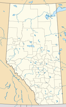  Location of Leslieville in Alberta | |
| Coordinates: 52.3833°N 114.6047°W | |
| Country | Canada |
| Province | Alberta |
| Census division | No. 9 |
| Municipal district | Clearwater County |
| Government | |
| • Type | Unincorporated |
| • Reeve | John Vandermeer |
| • Governing body | Clearwater County Council
|
| Area (2021)[1] | |
| • Land | 0.52 km2 (0.20 sq mi) |
| Elevation | 965 m (3,166 ft) |
| Population (2021)[1] | |
| • Total | 134 |
| • Density | 257.9/km2 (668/sq mi) |
| Time zone | UTC−7 (MST) |
| • Summer (DST) | UTC−6 (MDT) |
The hamlet is located in Census Division No. 9 and in the federal riding of Wetaskiwin. It was first settled in 1903.[3]
Demographics
In the 2021 Census of Population conducted by Statistics Canada, Leslieville had a population of 134 living in 60 of its 64 total private dwellings, a change of -11.3% from its 2016 population of 151. With a land area of 0.52 km2 (0.20 sq mi), it had a population density of 257.7/km2 (667.4/sq mi) in 2021.[1]
As a designated place in the 2016 Census of Population conducted by Statistics Canada, Leslieville had a population of 238 living in 90 of its 96 total private dwellings, a change of -0.4% from its 2011 population of 239. With a land area of 2.26 km2 (0.87 sq mi), it had a population density of 105.3/km2 (272.8/sq mi) in 2016.[4]
See also
- List of communities in Alberta
- List of designated places in Alberta
- List of hamlets in Alberta
References
- "Population and dwelling counts: Canada and designated places". Statistics Canada. February 9, 2022. Retrieved February 10, 2022.
- Alberta Municipal Affairs (2010-04-01). "Specialized and Rural Municipalities and Their Communities" (PDF). Archived from the original (PDF) on 2012-02-29. Retrieved 2010-06-22.
- Rocky Mountain House Reunion Historical Society (1977). Days Before Yesterday : History of Rocky Mountain House district. Rocky Mountain House: Rocky Mountain House Reunion Historical Society. p. 111. ISBN 0-88925-003-0.
- "Population and dwelling counts, for Canada, provinces and territories, and designated places, 2016 and 2011 censuses – 100% data (Alberta)". Statistics Canada. February 8, 2017. Retrieved February 13, 2017.
Subdivisions of Alberta | |
|---|---|
| Subdivisions |
|
| Communities |
|
| Cities and urban service areas |
|
| Hamlets |
|
| |


 | This Central Alberta location article is a stub. You can help Wikipedia by expanding it. |
Другой контент может иметь иную лицензию. Перед использованием материалов сайта WikiSort.org внимательно изучите правила лицензирования конкретных элементов наполнения сайта.
WikiSort.org - проект по пересортировке и дополнению контента Википедии