world.wikisort.org - Canada
Elm Creek is an unincorporated community recognized as a local urban district[1] in Manitoba, Canada. It is about 50 km west of Winnipeg and about 35 km southeast of Portage la Prairie. It is located in the Rural Municipality of Grey. It is home to the second largest fire hydrant in the world which was unveiled on Canada Day, 2001. It is also the home of the second largest H4 chondrite (a class of stony meteorite) ever found in Canada. The 8.2-kg mass was found by a local grader driver on a rural road in 1997. Elm Creek has a Kindergarten to Grade 12 school.
Elm Creek | |
|---|---|
Local urban district | |
 Elm Creek Fire Department | |
 Elm Creek Location of Elm Creek in Manitoba | |
| Coordinates: 49°40′32″N 97°59′33″W | |
| Country | Canada |
| Province | Manitoba |
| Region | Pembina Valley |
| Rural Municipality | Grey |
| Government | |
| • MP | Candice Bergen (CPC) |
| • MLA (Midland) | Blaine Pedersen (PC) |
| Area | |
| • Total | 2.69 km2 (1.04 sq mi) |
| Elevation | 257 m (843 ft) |
| Population (2016) | |
| • Total | 339 |
| • Density | 126.2/km2 (327/sq mi) |
| Time zone | UTC-6 (CST) |
| • Summer (DST) | UTC-5 (CDT) |
Climate
According to the Köppen Climate Classification system, Elm Creek has a humid continental climate, abbreviated "Dfb" on climate maps.[2]
| Climate data for Elm Creek | |||||||||||||
|---|---|---|---|---|---|---|---|---|---|---|---|---|---|
| Month | Jan | Feb | Mar | Apr | May | Jun | Jul | Aug | Sep | Oct | Nov | Dec | Year |
| Record high °C (°F) | 7.2 (45.0) |
10 (50) |
17.2 (63.0) |
35.5 (95.9) |
39.5 (103.1) |
38 (100) |
36.5 (97.7) |
39.5 (103.1) |
39 (102) |
32 (90) |
25 (77) |
8 (46) |
39.5 (103.1) |
| Average high °C (°F) | −11.5 (11.3) |
−8.3 (17.1) |
−1 (30) |
10.4 (50.7) |
19.8 (67.6) |
23.4 (74.1) |
25.9 (78.6) |
25 (77) |
18.4 (65.1) |
11 (52) |
−0.7 (30.7) |
−9.9 (14.2) |
8.6 (47.5) |
| Daily mean °C (°F) | −16.5 (2.3) |
−13.2 (8.2) |
−5.8 (21.6) |
4.2 (39.6) |
12.5 (54.5) |
16.9 (62.4) |
19.4 (66.9) |
18.2 (64.8) |
12.3 (54.1) |
5.5 (41.9) |
−5 (23) |
−14.6 (5.7) |
2.8 (37.0) |
| Average low °C (°F) | −21.4 (−6.5) |
−18.2 (−0.8) |
−10.7 (12.7) |
−2 (28) |
5.2 (41.4) |
10.4 (50.7) |
12.8 (55.0) |
11.3 (52.3) |
6.1 (43.0) |
−0.1 (31.8) |
−9.3 (15.3) |
−19.2 (−2.6) |
−2.9 (26.8) |
| Record low °C (°F) | −39.5 (−39.1) |
−38.9 (−38.0) |
−35.6 (−32.1) |
−26.7 (−16.1) |
−10 (14) |
−2 (28) |
3 (37) |
0 (32) |
−6.5 (20.3) |
−21 (−6) |
−35.5 (−31.9) |
−37.5 (−35.5) |
−39.5 (−39.1) |
| Average precipitation mm (inches) | 25.2 (0.99) |
20.8 (0.82) |
31.4 (1.24) |
33.4 (1.31) |
53.4 (2.10) |
81 (3.2) |
71.1 (2.80) |
70 (2.8) |
57.7 (2.27) |
38.4 (1.51) |
29.8 (1.17) |
30 (1.2) |
542.3 (21.35) |
| Source: Environment Canada[3] | |||||||||||||
Demographics
In the 2021 Census of Population conducted by Statistics Canada, Elm Creek had a population of 405 living in 145 of its 155 total private dwellings, a change of 19.5% from its 2016 population of 339. With a land area of 2.68 km2 (1.03 sq mi), it had a population density of 151.1/km2 (391.4/sq mi) in 2021.[4]
References
- "Local Urban Districts Regulation". Government of Manitoba. April 23, 2016. Retrieved April 24, 2016.
- Climate Summary for Elm Creek, Manitoba
- Environment Canada - Canadian Climate Normals 1971-2000—Canadian Climate Normals 1971–2000, accessed 16 April 2011
- "Population and dwelling counts: Canada and designated places". Statistics Canada. February 9, 2022. Retrieved Sep 3, 2022.
Places adjacent to Elm Creek, Manitoba | ||||||||||||||||
|---|---|---|---|---|---|---|---|---|---|---|---|---|---|---|---|---|
| ||||||||||||||||
Division No. 9, Manitoba (Portage la Prairie) | |||
|---|---|---|---|
| Cities | 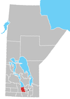 | ||
| Villages |
| ||
| Rural municipalities |
| ||
| First Nations |
| ||
| Indian reserves |
| ||
| Unincorporated communities |
| ||
| |||
This Manitoba location article is a stub. You can help Wikipedia by expanding it. |
Другой контент может иметь иную лицензию. Перед использованием материалов сайта WikiSort.org внимательно изучите правила лицензирования конкретных элементов наполнения сайта.
WikiSort.org - проект по пересортировке и дополнению контента Википедии