world.wikisort.org - Canada
Census Division No. 5 is a Statistics Canada statistical division composed of the areas of the province of Newfoundland and Labrador called Humber Valley, Bay of Islands, and White Bay. It covers a land area of 10,365.63 km² (4,002.19 sq mi), and had a population of 42,014 according to the 2016 census.[1]
Division No. 5 | |
|---|---|
Census division | |
 | |
| Coordinates: 48°57′33″N 57°55′34″W | |
| Country | Canada |
| Province | Newfoundland and Labrador |
| Government | |
| • MPs | Gudie Hutchings |
| Area | |
| • Total | 10,366.48 km2 (4,002.52 sq mi) |
| As of 2016 | |
| Population (2016)[1] | |
| • Total | 42,014 |
| • Density | 4.1/km2 (10/sq mi) |
Cities
- Corner Brook
Towns
- Cormack
- Cox's Cove
- Deer Lake
- Gillams
- Hampden
- Howley
- Hughes Brook
- Humber Arm South
- Irishtown-Summerside
- Jackson's Arm
- Lark Harbour
- Massey Drive
- McIvers
- Meadows
- Mount Moriah
- Pasadena
- Reidville
- Steady Brook
- York Harbour
Unorganized subdivisions
- Subdivision A (Includes: St. Jude's, and Hinds Lake)
- Subdivision C (Includes: Spruce Brook, George's Lake, Pinchgut Lake)
- Subdivision D (Includes: North Arm, Middle Arm, Goose Arm, Serpentine Lake)
- Subdivision E (Includes: Galeville, The Beaches)
- Subdivision F (Includes: Pynn's Brook, Little Rapids, Humber Valley Resort)
- Subdivision G (Includes: Pollards Point, Sops Arm)
Demographics
| Year | Pop. | ±% |
|---|---|---|
| 2006 | 40,805 | — |
| 2011 | 41,004 | +0.5% |
| 2016 | 42,014 | +2.5% |
| [1][2] | ||
In the 2021 Census of Population conducted by Statistics Canada, Division No. 5 had a population of 40,396 living in 17,967 of its 20,875 total private dwellings, a change of -3.9% from its 2016 population of 42,014. With a land area of 10,293.76 km2 (3,974.44 sq mi), it had a population density of 3.9/km2 (10.2/sq mi) in 2021.[3]
References
- "Census Profile, 2016 Census: Division No. 5, Census division [Census division], Newfoundland and Labrador". Statistics Canada. Retrieved October 15, 2019.
- "2011 Census Profile - Division No. 5, Census division". Statistics Canada. Retrieved March 2, 2012.
- "Population and dwelling counts: Canada and census divisions". Statistics Canada. February 9, 2022. Retrieved April 2, 2022.
Sources
- "(Code 1005) Census Profile". 2011 census. Statistics Canada. 2012.
Places adjacent to Division No. 5, Newfoundland and Labrador | ||||||||||||||||
|---|---|---|---|---|---|---|---|---|---|---|---|---|---|---|---|---|
| ||||||||||||||||


Division No. 5, Newfoundland and Labrador (Humber District) | ||
|---|---|---|
| Cities | 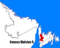 | |
| Towns | ||
| Unorganized subdivisions |
| |
| Designated places |
| |
| ||
Subdivisions of Newfoundland and Labrador | |
|---|---|
| |
| Subdivisions and statistical units |
|
| Communities |
|
| Cities | |
| |


Текст в блоке "Читать" взят с сайта "Википедия" и доступен по лицензии Creative Commons Attribution-ShareAlike; в отдельных случаях могут действовать дополнительные условия.
Другой контент может иметь иную лицензию. Перед использованием материалов сайта WikiSort.org внимательно изучите правила лицензирования конкретных элементов наполнения сайта.
Другой контент может иметь иную лицензию. Перед использованием материалов сайта WikiSort.org внимательно изучите правила лицензирования конкретных элементов наполнения сайта.
2019-2026
WikiSort.org - проект по пересортировке и дополнению контента Википедии
WikiSort.org - проект по пересортировке и дополнению контента Википедии