world.wikisort.org - Canada
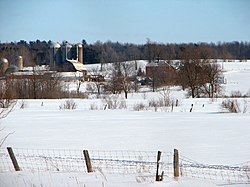
Champlain is a township in eastern Ontario, Canada, in the United Counties of Prescott and Russell on the Ottawa River. It was formed on January 1, 1998, through the amalgamation of West Hawkesbury Township, Longueuil Township, Town of Vankleek Hill, and the Village of L'Orignal.
Champlain | |
|---|---|
Township (lower-tier) | |
| Township of Champlain Canton de Champlain | |
 | |
 Champlain  Champlain | |
| Coordinates: 45°32′N 74°39′W | |
| Country | |
| Province | |
| County | Prescott and Russell |
| Formed | January 1, 1998 |
| Government | |
| • Mayor | Normand Riopel |
| • Federal riding | Glengarry—Prescott—Russell |
| • Prov. riding | Glengarry—Prescott—Russell |
| Area | |
| • Land | 207.27 km2 (80.03 sq mi) |
| Population (2016)[1] | |
| • Total | 8,706 |
| • Density | 42.0/km2 (109/sq mi) |
| Time zone | UTC-5 (EST) |
| • Summer (DST) | UTC-4 (EDT) |
| Postal Code FSA | K0B |
| Area code(s) | 613, 343 |
| Website | www.champlain.ca |
Communities
The township comprises the communities of Aberdeen, Cassburn, Green Lane, Happy Hollow, Henrys Corners, L'Ange-Gardien, L'Orignal, Pleasant Corners, Ritchance, Riviera Estate, Sandy Hill, Springhill, Vankleek Hill, Vankleek Hill Station, Village Lanthier, and St. Eugene. The township administrative offices are located in Vankleek Hill.
Demographics
In the 2021 Census of Population conducted by Statistics Canada, Champlain had a population of 8,665 living in 3,750 of its 3,964 total private dwellings, a change of -0.5% from its 2016 population of 8,706. With a land area of 207.02 km2 (79.93 sq mi), it had a population density of 41.9/km2 (108.4/sq mi) in 2021.[2]
| 2021 | 2016 | 2011 | |
|---|---|---|---|
| Population | 1,807 (+4.1% from 2016) | 8,706 (+1.6% from 2011) | 8,573 (-1.3% from 2006) |
| Land area | 58.17 km2 (22.46 sq mi) | 207.27 km2 (80.03 sq mi) | 207.24 km2 (80.02 sq mi) |
| Population density | 31.1/km2 (81/sq mi) | 42.0/km2 (109/sq mi) | 41.4/km2 (107/sq mi) |
| Median age | 54 (M: 54, F: 54) | 50.8 (M: 50.4, F: 51.1) | |
| Total private dwellings | 860 | 3,910 | 3,769 |
| Median household income | $72,521 |
| Year | Pop. | ±% |
|---|---|---|
| 1996 | 8,375 | — |
| 2001 | 8,591 | +2.6% |
| 2006 | 8,683 | +1.1% |
| 2011 | 8,573 | −1.3% |
| 2016 | 8,706 | +1.6% |
| [8][9][1] | ||
See also
- List of townships in Ontario
- List of francophone communities in Ontario
References
- "Census Profile, 2016 Census: Champlain, Township". Statistics Canada. Retrieved July 1, 2019.
- "Population and dwelling counts: Canada, provinces and territories, census divisions and census subdivisions (municipalities), Ontario". Statistics Canada. February 9, 2022. Retrieved April 2, 2022.
- "2021 Community Profiles". 2021 Canadian Census. Statistics Canada. February 4, 2022. Retrieved 2022-04-27.
- "2016 Community Profiles". 2016 Canadian Census. Statistics Canada. August 12, 2021. Retrieved 2019-07-01.
- "2011 Community Profiles". 2011 Canadian Census. Statistics Canada. March 21, 2019. Retrieved 2012-02-28.
- "2006 Community Profiles". 2006 Canadian Census. Statistics Canada. August 20, 2019.
- "2001 Community Profiles". 2001 Canadian Census. Statistics Canada. July 18, 2021.
- Statistics Canada: 2001, 2006
- "Champlain census profile". 2011 Census of Population. Statistics Canada. Retrieved 2012-02-28.
External links
 Media related to Champlain, Ontario at Wikimedia Commons
- Official website
На других языках
[de] Champlain (Ontario)
Champlain (offiziell Township of Champlain) ist eine ländliche Flächengemeinde im Osten der kanadischen Provinz Ontario. Sie liegt im Prescott and Russell United Counties und ist ein Township mit dem Status einer Lower Tier (untergeordneten Gemeinde).[2]- [en] Champlain, Ontario
Другой контент может иметь иную лицензию. Перед использованием материалов сайта WikiSort.org внимательно изучите правила лицензирования конкретных элементов наполнения сайта.
WikiSort.org - проект по пересортировке и дополнению контента Википедии