world.wikisort.org - Canada
Camrose County is a municipal district in central Alberta, Canada. It is located in Census Division 10, around the City of Camrose.
Camrose County | |
|---|---|
Municipal district | |
|
Logo | |
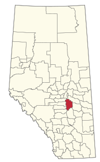 Location within Alberta | |
| Coordinates: 53°01′22″N 112°49′42″W | |
| Country | Canada |
| Province | Alberta |
| Region | Central Alberta |
| Census division | 10 |
| Established | 1944 |
| Incorporated | 1963 |
| Government | |
| • Reeve | Cindy Trautman |
| • Governing body | Camrose County Council
|
| • Administrator | Paul King |
| • Administrative office | Camrose |
| Area (2021)[2] | |
| • Land | 3,291.75 km2 (1,270.95 sq mi) |
| Population (2021)[2] | |
| • Total | 8,504 |
| • Density | 2.6/km2 (7/sq mi) |
| Time zone | UTC-7 (MST) |
| • Summer (DST) | UTC−6 (MDT) |
| Website | county.camrose.ab.ca |
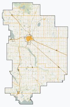
Geography
Communities and localities
|
The following urban municipalities are surrounded by Camrose County.[3][4]
|
The following hamlets are located within Camrose County.[4]
|
The following localities are located within Camrose County.[7]
- Localities
|
|
Demographics
In the 2021 Census of Population conducted by Statistics Canada, Camrose County had a population of 8,504 living in 3,223 of its 3,688 total private dwellings, a change of -1.8% from its 2016 population of 8,660. With a land area of 3,291.75 km2 (1,270.95 sq mi), it had a population density of 2.6/km2 (6.7/sq mi) in 2021.[2]
In the 2016 Census of Population conducted by Statistics Canada, Camrose County had a population of 8,458 living in 3,118 of its 3,492 total private dwellings, a 5.7% change from its 2011 population of 8,004. With a land area of 3,324.21 km2 (1,283.48 sq mi), it had a population density of 2.5/km2 (6.6/sq mi) in 2016.[8]
See also
- List of communities in Alberta
- List of municipal districts in Alberta
References
- "Municipal Officials Search". Alberta Municipal Affairs. May 9, 2019. Retrieved October 1, 2021.
- "Population and dwelling counts: Canada, provinces and territories, and census subdivisions (municipalities)". Statistics Canada. February 9, 2022. Retrieved February 9, 2022.
- "Camrose, City (Census Subdivision), Alberta". Statistics Canada. June 20, 2012. Retrieved August 13, 2012.
- "Specialized and Rural Municipalities and Their Communities" (PDF). Alberta Municipal Affairs. January 12, 2022. Retrieved January 21, 2022.
- "O.C. 190/2019". Government of Alberta. October 8, 2019. Retrieved October 13, 2019.
- "O.C. 328/2012". Province of Alberta. October 17, 2012. Retrieved November 1, 2012.
- "Standard Geographical Classification (SGC) 2006, Economic Regions: 4810001 - Camrose County No. 22, geographical codes and localities, 2006". Statistics Canada. March 5, 2010. Archived from the original on May 25, 2013. Retrieved August 11, 2012.
- "Population and dwelling counts, for Canada, provinces and territories, and census subdivisions (municipalities), 2016 and 2011 censuses – 100% data (Alberta)". Statistics Canada. February 8, 2017. Retrieved February 8, 2017.
External links
Places adjacent to Camrose County | ||||||||||||||||
|---|---|---|---|---|---|---|---|---|---|---|---|---|---|---|---|---|
| ||||||||||||||||
Subdivisions of Alberta | |||||||
|---|---|---|---|---|---|---|---|
| Subdivisions |
| ||||||
| Communities |
| ||||||
| Cities and urban service areas |
| ||||||
| Rural municipalities |
| ||||||
| Specialized municipalities |
| ||||||
| |||||||
| Authority control |
|
|---|
Другой контент может иметь иную лицензию. Перед использованием материалов сайта WikiSort.org внимательно изучите правила лицензирования конкретных элементов наполнения сайта.
WikiSort.org - проект по пересортировке и дополнению контента Википедии