world.wikisort.org - Canada
Blissville is a civil parish in Sunbury County, New Brunswick, Canada.[2]
Blissville | |
|---|---|
Parish | |
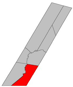 Location within Sunbury County, New Brunswick | |
| Country | |
| Province | |
| County | Sunbury County |
| Erected | 1835 |
| Area | |
| • Land | 341.74 km2 (131.95 sq mi) |
| Population (2021)[1] | |
| • Total | 777 |
| • Density | 2.3/km2 (6/sq mi) |
| • Change 2016-2021 | |
| • Dwellings | 369 |
| Time zone | UTC-4 (AST) |
| • Summer (DST) | UTC-3 (ADT) |
For governance purposes it is divided between CFB Gagetown and the local service district of the parish of Blissville,[3] which is a member of Regional Service Commission 11 (RSC11).[4]
Origin of name
The parish was probably named in honour of John Murray Bliss,[5] senior justice of the Supreme Court of New Brunswick at the time the Act erecting the parish[6] was passed in 1834 but died before it became effective in January 1835.
History
Blissville was erected in 1835 from Burton and Lincoln Parishes.[6]
In 1874 Gladstone Parish was erected from the western part of Blissville.[7]
In 1896 the land boundary with Gladstone was completely altered, adding a large area to Blissville; the boundary with Burton was altered along the Nerepis Road.[8]
In 1949 the boundary with Burton was restored to its pre-1896 line.[9]
Boundaries
Blissville Parish is bounded:[2][10][11][12]
- on the north beginning at a point on the eastern bank of the Oromocto River about 1.2 kilometres downstream of the mouth of Shaw Creek, then running south 66º east[lower-alpha 1] to the Queens County line;
- on the southeast by the Sunbury County line;
- on the south by the Charlotte County;
- on the west by a line beginning at a point on the Charlotte County about 2.9 kilometres west of the South Oromocto Lake Road, then running north 67º east[lower-alpha 2] about 19.2 kilometres to the rear line of grants along the western side of the South Branch Oromocto River, then northerly about 2.2 kilometres along the rear line of grants to the northern line of a grant to Nathaniel Hubbard, which is also the southern boundary of Fredericton Junction, then easterly to the river, then down the South Branch Oromocto River and the Oromocto River to the starting point.
Communities
Communities at least partly within the parish;[10][11][12] italics indicate a community expropriated for CFB Gagetown
- Blissville
- Central Blissville
- Germany
- Hoyt
- Hoyt Station
- Juvenile Settlement
- Mill Settlement
- Mill Settlement West
- Patterson
- Sand Brook
- Tweedsmuir
Bodies of water
Bodies of water[lower-alpha 3] at least partly in the parish:[10][11][12]
- Oromocto River
- South Branch Oromocto River
- Brizley Stream
- Piskahegan Stream
- Back Creek
- Bass Creek
- White Birch Lake
Islands
Islands in the parish:[10][11][12]
- Basley Island
Other notable places
Parks, historic sites, and other noteworthy places in the parish.[10][11][12]
Demographics
Population
|
LanguageMother tongue (2016)[17]
|
Access Routes
Highways and numbered routes that run through the parish, including external routes that start or finish at the parish limits:[18]
|
|
|
|
See also
- List of parishes in New Brunswick
Notes
- By the magnet of 1834,[6] when declination in the area was between 16º and 17º west of north.[13] The Territorial Division Act clause referring to magnetic direction bearings was omitted in the 1952[14] and 1973 Revised Statutes.[2]
- By the magnet of 1896, when declination in the area was about 20º west of north.[13]
- Not including brooks, ponds or coves.
References
- "Census Profile". Statistics Canada. 26 October 2022. Retrieved 29 October 2022.
- "Chapter T-3 Territorial Division Act". Government of New Brunswick. Retrieved 13 November 2020.
- "New Brunswick Regulation 84-168 under the Municipalities Act (O.C. 84-582)". Government of New Brunswick. Retrieved 22 July 2020.
- "Communities in each of the 12 Regional Service Commissions (RSC) / Les communautés dans chacune des 12 Commissions de services régionaux (CSR)" (PDF), Government of New Brunswick, July 2017, retrieved 2 February 2021
- Ganong, William F. (1896). A Monograph of the Place-Nomenclature of the Province of New Brunswick. Royal Society of Canada. p. 221. Retrieved 17 March 2021.
- "4 Wm. IV c. 42 An Act to erect a new Parish in the County of Sunbury.". Acts of the General Assembly of His Majesty's Province of New Brunswick, Passed in the Year 1834. Fredericton: Government of New Brunswick. 1834. pp. 103–104. Retrieved 27 March 2021.
- "37 Vic. c. 38 An Act to erect a part of the Parish of Blissville, in the County of Sunbury, into a separate Town or Parish.". Acts of the General Assembly of Her Majesty's Province of New Brunswick. Passed in the Months of March & April 1874. Fredericton: Government of New Brunswick. 1874. pp. 112–113. Available as a free ebook from Google Books.
- "59 Vic. c. 8 An Act to Revise and Codify an Act to Provide for the Division of the Province into Counties, Towns and Parishes.". Acts of the General Assembly of Her Majesty's Province of New Brunswick. Passed in the Month of March, 1896. Fredericton: Government of New Brunswick. 1896. pp. 86–123. Available as a free ebook from Google Books.
- "13 Geo. VI c. 146 An Act to Amend Chapter 2 of the Revised Statutes, 1927, Respecting the Division of the Province into Counties Towns and Parishes, in so far as It Relates to the County of Sunbury.". Acts of the Legislative Assembly of New Brunswick Passed During the Session of 1949. Fredericton: Government of New Brunswick. 1949. p. 468.
- "No. 137". Provincial Archives of New Brunswick. Department of Natural Resources and Energy Development. Retrieved 22 June 2021. Remainder of parish on maps 138, 147, 148, and 155 at same site.
- "410" (PDF). Transportation and Infrastructure. Government of New Brunswick. Retrieved 22 June 2021. Remainder of parish on mapbooks 411, 427–429, 442, 443, 457, and 458 at same site.
- "Search the Canadian Geographical Names Database (CGNDB)". Government of Canada. Retrieved 22 June 2021.
- "Historical Magnetic Declination". National Oceanic and Atmospheric Administration. Retrieved 28 April 2021.
- "Chapter 227 Territorial Division Act". The Revised Statutes of New Brunswick 1952 Volume III. Fredericton: Government of New Brunswick. 1952. pp. 3725–3771.
- Statistics Canada: 2001, 2006 census
- 2011 Statistics Canada Census Profile: Blissville Parish, New Brunswick
- "Census Profile, 2016 Census Blissville, Parish [Census subdivision], New Brunswick". Statistics Canada. Retrieved 30 September 2019.
- Atlantic Canada Back Road Atlas ISBN 978-1-55368-618-7
Places adjacent to Blissville Parish, New Brunswick | |
|---|---|
Subdivisions of New Brunswick | |
|---|---|
| Subdivisions |
|
| Cities | |
| Counties | |
| |
Другой контент может иметь иную лицензию. Перед использованием материалов сайта WikiSort.org внимательно изучите правила лицензирования конкретных элементов наполнения сайта.
WikiSort.org - проект по пересортировке и дополнению контента Википедии