world.wikisort.org - Brésil
Uiramutã est un municipio du nord-est de l'État du Roraima. Sa population est de 7 403 habitants en 2007 pour une superficie de 8 066 km2, soit 0,9 hab/km2.
Cet article est une ébauche concernant une localité brésilienne.
Vous pouvez partager vos connaissances en l’améliorant (comment ?) selon les recommandations des projets correspondants.
| Uiramutã | ||||
 Héraldique |
 Drapeau |
|||
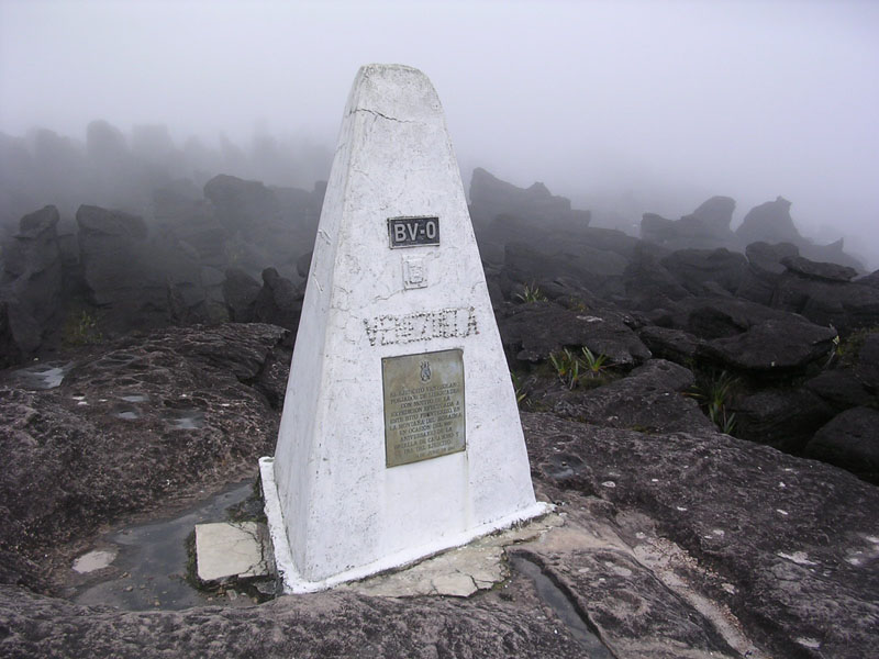 Le tripoint Brésil-Venezuela-Guyana sur le mont Roraima. | ||||
| Administration | ||||
|---|---|---|---|---|
| Pays | ||||
| Région | Nord | |||
| État | ||||
| Langue(s) | Portugais | |||
| Maire | Eliésio Cavalcanti de Lima (PT) | |||
| Code postal | 69 358-000 | |||
| Fuseau horaireHeure d'été | UTC-4UTC-4 | |||
| Indicatif | 95 | |||
| Démographie | ||||
| Gentilé | Uiramutense | |||
| Population | 7 403 hab.[1] (01-04-2007) | |||
| Densité | 0,92 hab./km2 | |||
| Géographie | ||||
| Coordonnées | 4° 35′ 35″ nord, 60° 10′ 10″ ouest | |||
| Altitude | 0 m |
|||
| Superficie | 806 600 ha = 8 066 km2 | |||
| Divers | ||||
| Site(s) touristique(s) | Écotourisme | |||
| FondateurDate de fondation | Loi fédérale n° 09817 octobre 1995 | |||
| Localisation | ||||
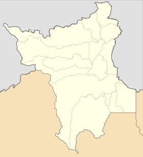
| Géolocalisation sur la carte : Brésil
Géolocalisation sur la carte : Brésil
Géolocalisation sur la carte : Roraima
| ||||
| Liens | ||||
| Site web | http://www.uiramuta.rr.gov.br/portal1/intro.asp?iIdMun=100114015 | |||
| modifier |
||||


Elle est située à la frontière avec le Venezuela au Nord-Ouest, celle avec le Guyana au Nord, au Nord-Est et à l'Est, Normandia au Sud et Pacaraima au Sud-Ouest.
La municipalité a sur son territoire le Mont Caburaí, de 1.456 m d'altitude, sur la frontière avec le Guyana. À 05° 16' 20" de latitude Nord, c'est le point le plus septentrional du Brésil. Le Rio Ailã prend sa source sur ses pentes. Elle est aussi traversée par le rio Cotingo. Le mont Roraima, aussi sur le territoire municipal, est le point de frontière entre les trois pays et est le dixième sommet le plus haut du pays, avec 2 872 mètres d'altitude[2].
La majorité de la population est indigène[3].
Références
- IBGE
- (en) « Mount Roraima-Guyana High Point, Guyana/Venezuela », Peakbagger (consulté le )
- Vasconcelo Quadros et Anna Beatriz Anjos, « Profitant de la crise sanitaire, la déforestation et le pillage de l’Amazonie et des terres autochtones s’intensifient », sur Basta,
 Portail du Roraima
На других языках
[en] Uiramutã
Uiramutã (Portuguese pronunciation: [wiɾamuˈtɐ̃]) is a municipality located in the northeast of the state of Roraima in Brazil. Its population is 10,789 (as of 2020) and its area is 8,066 km2. It is the northernmost municipality of Brazil, with Monte Caburaí being the northernmost point. West of this mountain, there is also the Monte Roraima, the tallest mountain in Roraima and in Guyana, located in the triple frontier of Brazil, Guyana and Venezuela. Still, Uiramutã holds the title of the northernmost urban seat of a municipality in Brazil. Its counterparts in the South, West and East are respectively Chuí, state of Rio Grande do Sul; Mâncio Lima, Acre; and João Pessoa, Paraíba.[es] Uiramutã
Uiramutã es un municipio del nordeste del estado de Roraima, siendo el municipio más septentrional del Brasil. Uiramutã Esporte Clube- [fr] Uiramutã
[ru] Уйрамутан
Уйрамутан (порт. Uiramutã) — муниципалитет в Бразилии, входит в штат Рорайма. Составная часть мезорегиона Север штата Рорайма. Входит в экономико-статистический микрорегион Нордести-ди-Рорайма. Население составляет 8 375 человек на 2010 год. Занимает площадь 8 065,564 км². Плотность населения — 1,04 чел./км².Другой контент может иметь иную лицензию. Перед использованием материалов сайта WikiSort.org внимательно изучите правила лицензирования конкретных элементов наполнения сайта.
WikiSort.org - проект по пересортировке и дополнению контента Википедии