world.wikisort.org - Brazil
The Subprefecture of Pirituba-Jaraguá is one of 32 subprefectures of the city of São Paulo, Brazil. It comprises three districts: Pirituba, São Domingos, and Jaraguá.[1] The highest point of the municipality of São Paulo, Pico do Jaraguá, is located in this place. It's also where the roads connecting Campinas and the Central-West region of Brazil have the start point.
Subprefecture of Pirituba-Jaraguá | |
|---|---|
Subprefecture | |
 Location of the Subprefecture of Pirituba-Jaraguá in São Paulo | |
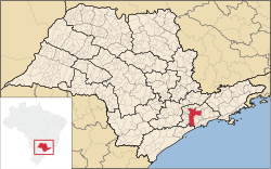 Location of municipality of São Paulo within the State of São Paulo | |
| Country | |
| Region | Southeast |
| State | |
| Municipality | |
| Administrative Zone | Northwest |
| Districts | Pirituba, São Domingos, Jaraguá |
| Government | |
| • Type | Subprefecture |
| • Subprefect | Sergio Carlos Filho |
| Area | |
| • Total | 55.05 km2 (21.25 sq mi) |
| Population (2008) | |
| • Total | 442,722 |
| Website | Subprefeitura Pirituba-Jaraguá (Portuguese) |
References
- Official Subprefecture Website (Portuguese) Archived 2011-01-26 at the Wayback Machine
This geographical article relating to the state of São Paulo is a stub. You can help Wikipedia by expanding it. |
На других языках
- [en] Subprefecture of Pirituba-Jaraguá
[ru] Субпрефектура Пиритуба
Субпрефектура Пиритуба (порт. Subprefeitura de Pirituba) — одна из 31 субпрефектур города Сан-Паулу, находится в северо-восточной части города. Общая площадь 54,7 км². Численность населения — 442 722 жителя.Текст в блоке "Читать" взят с сайта "Википедия" и доступен по лицензии Creative Commons Attribution-ShareAlike; в отдельных случаях могут действовать дополнительные условия.
Другой контент может иметь иную лицензию. Перед использованием материалов сайта WikiSort.org внимательно изучите правила лицензирования конкретных элементов наполнения сайта.
Другой контент может иметь иную лицензию. Перед использованием материалов сайта WikiSort.org внимательно изучите правила лицензирования конкретных элементов наполнения сайта.
2019-2026
WikiSort.org - проект по пересортировке и дополнению контента Википедии
WikiSort.org - проект по пересортировке и дополнению контента Википедии