world.wikisort.org - Brazil
Mairiporã is a Brazilian municipality in São Paulo state. It is part of the São Paulo metropolitan area. The population is 101,937 (2020 est.) in an area of 321 km².[2]
Mairiporã | |
|---|---|
Municipality | |
 | |
 Flag  Coat of arms | |
 Location in São Paulo state | |
 Mairiporã Location in Brazil | |
| Coordinates: 23°19′8″S 46°35′13″W | |
| Country | Brazil |
| Region | Southeast |
| State | São Paulo |
| Area | |
| • Total | 321 km2 (124 sq mi) |
| Population (2020 [1]) | |
| • Total | 101,937 |
| • Density | 320/km2 (820/sq mi) |
| Time zone | UTC-03:00 (BRT) |
| • Summer (DST) | UTC-02:00 (BRST) |
| Website | www |
History
It became a municipality in 1889, separating from Guarulhos, it was named "Juqueri", and it comprised also what today are the cities of Franco da Rocha, Caieiras and Francisco Morato. The current name was adopted in December 1948, and means "beautiful city" (mairy: village, city + poranga: beautiful).
Geography
Mairiporã is situated at an average altitude of 790m. The highest points of Mairiporã are in Serra da Cantareira, where it reaches an altitude of over 1100m in some areas.
Climate: Like in all of the São Paulo metropolitan area, the climate is subtropical. Summer is considerably warm and rainy while the winter is mild. The average annual temperature is about 18 °C. The coldest month is July with an average 14 °C and the warmest February with an average 22 °C. The annual pluviometric index is about 1400mm.
Roads
BR-381 Rodovia Fernão Dias.
Road connecting São Paulo Capital City to Belo Horizonte in the state of Minas Gerais. BR-381 crosses Mairiporã from south to north, from Parque suíço in the south to Terra Preta in the north.
SP-023 Rodovia Prefeito Luiz Salomão Chamma.
Connects SP-332 Rodovia Tancredo de Almeida Neves in Franco da Rocha to BR-381 Rodovia Fernão Dias.
Demographics
Data from 2000 Census
Total population - 60.111
- Urban Population - 48,077
- Rural Population - 12,034
- Men - 30,214
- Women - 29,897
Population density: 186.97 people per km2
Infant mortality: 18.60 per thousand
Life expectancy: 69.82 years
Total fertility rate: 2.22 per woman
Literacy rate: 90.7%
Human Development Index: 0.803
- Standard of living: 0.784
- Life Expectancy: 0.747
- Education: 0.877
(Source: IPEADATA)
Tourism
The municipality contains part of the 7,917 hectares (19,560 acres) Cantareira State Park, created in 1962, which protects a large part of the metropolitan São Paulo water supply.[3] Mairiporã is a city in Serra da Cantareira north of São Paulo City. It is in a great location for tourists who are searching for connection with nature and tranquility yet close to the capital. The city is rich in many radical sports, like Paraglider in Pico do Olho D'água, downhill in Trilha da Saracura, the Trilha dos Macacos with waterfalls among others.
Gallery
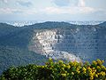 São Paulo view from Pico do olho d'água, highest place in the city
 View of Nossa Senhora do Desterro Church
 Neighborhood in Mairiporã city center
 Sete Quedas(Seven Falls) Dam and waterfall
 Sete Quedas(Seven Falls) Dam and waterfall
 Mairiporã city entrance


References
| Wikivoyage has a travel guide for Mairiporã. |
- IBGE 2020
- Instituto Brasileiro de Geografia e Estatística
- Leonel, Cristiane (June 2009), Plano de Manejo do Parque Estadual da Cantareira: Resumo Executivo (PDF) (in Portuguese), SEMA/SP, p. vi, retrieved 2016-12-10[dead link]
Authority control | |
|---|---|
| General |
|
| National libraries | |
| Other |
|
На других языках
- [en] Mairiporã
[es] Mairiporã
Mairiporã, o españolizado Mairiporán o también Mairiporá, es un municipio de la Región Metropolitana de São Paulo, en el estado de São Paulo. La población estimada en 2009 era de 79 155 habitantes y el área es de 321,5km², lo que resulta en una densidad demográfica de 233,4 habitantes por kilómetro cuadrado.[ru] Майрипоран
Майрипоран (порт. Mairiporã) — муниципалитет в Бразилии, входит в штат Сан-Паулу. Составная часть мезорегиона Агломерация Сан-Паулу. Находится в составе крупной городской агломерации Агломерация Сан-Паулу. Входит в экономико-статистический микрорегион Франку-да-Роша. Население составляет 75 022 человека на 2006 год. Занимает площадь 321,480 км². Плотность населения — 233,4 чел./км².Другой контент может иметь иную лицензию. Перед использованием материалов сайта WikiSort.org внимательно изучите правила лицензирования конкретных элементов наполнения сайта.
WikiSort.org - проект по пересортировке и дополнению контента Википедии