world.wikisort.org - Brazil
Guajará-Mirim is a municipality in the Brazilian state of Rondônia. It is located at an altitude of 128 meters. Its population was 46,556 (2020) and its area is 24,856 km².[2]
Guajará-Mirim | |
|---|---|
Municipality | |
 | |
 Flag  Coat of arms | |
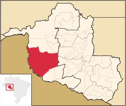 Location in Rondônia state | |
 Guajará-Mirim Location in Brazil | |
| Coordinates: 10°46′58″S 65°20′22″W | |
| Country | Brazil |
| Region | North |
| State | Rondônia |
| Area | |
| • Total | 24,856 km2 (9,597 sq mi) |
| Population (2020 [1]) | |
| • Total | 46,556 |
| • Density | 1.9/km2 (4.9/sq mi) |
| Time zone | UTC-04:00 (BRT-1) |
Location
Guajará-Mirim lies along the Mamoré River, just across the Bolivian border town of Guayaramerín. It was once the southern terminus of the Estrada de Ferro Madeira-Mamoré (the Madeira-Mamoré Railway), which was inaugurated in 1912. It is the seat of the Roman Catholic Diocese of Guajará-Mirim.
Conservation
The municipality contains the 22,540 hectares (55,700 acres) Traçadal Biological Reserve, a strictly protected area that was created in 1990.[3] It contains 2.33% of the 216,568 hectares (535,150 acres) Guajará-Mirim State Park, created in 1990.[4] It contains the 46,438 hectares (114,750 acres) Rio Ouro Preto Biological Reserve, created in 1990.[5] It contains 73.45% of the 204,632 hectares (505,660 acres) Rio Ouro Preto Extractive Reserve, also created in 1990.[6] The municipality contains 47.5% of the 146,400 hectares (362,000 acres) Rio Cautário State Extractive Reserve, created in 1995.[7] It contains the 73,818 hectares (182,410 acres) Rio Cautário Federal Extractive Reserve, created in 2001.[8]
References
- IBGE 2020
- IBGE -
- REBIO do Traçadal – ISA, Informações gerais.
- PES de Guajará-Mirim – ISA, Informações gerais.
- REBIO do Rio Ouro Preto – ISA, Informações gerais.
- RESEX do Rio Ouro Preto – ISA, Informações gerais.
- RESEX Rio Cautário (Estadual) – ISA.
- RESEX do Rio Cautário – ISA, Informações gerais.
Sources
- PES de Guajará-Mirim (in Portuguese), ISA: Instituto Socioambiental, retrieved 2016-07-31
- REBIO do Rio Ouro Preto (in Portuguese), ISA: Instituto Socioambiental, retrieved 2016-07-31
- REBIO do Traçadal (in Portuguese), ISA: Instituto Socioambiental, retrieved 2016-06-05
- RESEX do Rio Cautário (in Portuguese), ISA: Instituto Socioambiental, retrieved 2016-09-14
- RESEX Rio Cautário (Estadual) (in Portuguese), ISA: Instituto Socioambiental, retrieved 2016-09-15
- RESEX do Rio Ouro Preto (in Portuguese), ISA: Instituto Socioambiental, retrieved 2016-07-31
Capital: Porto Velho | ||
| Alvorada d'Oeste |  | |
| Ariquemes |
| |
| Cacoal |
| |
| Colorado do Oeste |
| |
| Guajara-Mirim |
| |
| Ji-Parana |
| |
| Porto Velho |
| |
| Vilhena |
| |
Authority control | |
|---|---|
| General |
|
| National libraries | |
This Rondônia, Brazil location article is a stub. You can help Wikipedia by expanding it. |
На других языках
- [en] Guajará-Mirim
[ru] Гуажара-Мирин
Гуажара-Мирин (порт. Guajará-Mirim) — муниципалитет в Бразилии, входит в штат Рондония. Составная часть мезорегиона Мадейра-Гуапоре. Входит в экономико-статистический микрорегион Гуажара-Мирин. Население составляет 41 656 человек на 2010 год. Занимает площадь 24 855,72 км². Плотность населения — 1,68 чел./км².Другой контент может иметь иную лицензию. Перед использованием материалов сайта WikiSort.org внимательно изучите правила лицензирования конкретных элементов наполнения сайта.
WikiSort.org - проект по пересортировке и дополнению контента Википедии