world.wikisort.org - Brazil
Águas Claras is an administrative region in the Federal District in Brazil.
This article needs additional citations for verification. (April 2017) |
This article may be expanded with text translated from the corresponding article in Portuguese. (January 2017) Click [show] for important translation instructions.
|
Águas Claras | |
|---|---|
Administrative region | |
| Região Administrativa de Águas Claras Administrative Region of Águas Claras | |
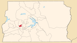 Location in the Federal District | |
| Coordinates: 15°50′25″S 48°01′40″W | |
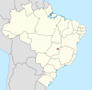
| Country | |
| Region | Central-West |
| State | |
| Founded | April 8, 2003 |
| Government | |
| • Regional administrator | Manoel Valdeci Machado Elias[1] |
| Area | |
| • Total | 31.5 km2 (12.2 sq mi) |
| Population (2010) | |
| • Total | 135,685[2] |
| • Density | 4,307/km2 (11,160/sq mi) |
| Time zone | UTC−3 (BRT) |
| Area code(s) | +55 61 |
| Website | www.aguasclaras.df.gov.br |

Etymology
The region's name, Portuguese for clear waters, references to the stream within the region which flows into Paranoá Lake.[citation needed]
History
In December 1992, District Law No. 385 authorized the implementation of Águas Claras, then part of Taguatinga; its occupation plan was approved later that same year.[citation needed] Designed by architect and urbanist Paulo Zimbres, Águas Claras began construction shortly afterwards. It was separated from Taguatinga as the Federal District's twentieth administrative region on May 6 2003, through District Law No. 3153.[citation needed]
The neighborhood was notable for its accelerated growth, with large and diversified real estate developments.[citation needed]
Águas Claras has an area of approximately 31.5 km² [citation needed] and a population of just over 135 thousand.[2]

See also
- List of administrative regions of the Federal District
References
- "Perfil do administrador" (in Portuguese). Administração Regional de Águas Claras, DF. Retrieved 2015-01-01.
- "Pesquisa Distrital por Amostra de Domicílios - 2010/2011" (PDF) (in Portuguese). Codeplan. Retrieved 2013-04-09.
External links
Seat of government: Brasília | ||||||||
|  | |||||||
This Federal District, Brazil geography article is a stub. You can help Wikipedia by expanding it. |
Другой контент может иметь иную лицензию. Перед использованием материалов сайта WikiSort.org внимательно изучите правила лицензирования конкретных элементов наполнения сайта.
WikiSort.org - проект по пересортировке и дополнению контента Википедии