world.wikisort.org - Bosnia_and_Herzegovina
Lukomir (Serbian Cyrillic: Лукомир) is a village in Konjic municipality, in Bosnia and Herzegovina. It consists of two settlements: Donji (Lower) and Gornji (Upper) Lukomir.
Lukomir
Лукомир | |
|---|---|
Village | |
 | |
 Lukomir | |
| Coordinates: 43°38′N 18°11′E | |
| Country | |
| Entity | Federation of Bosnia and Herzegovina |
| Canton | |
| Municipality | |
| Area | |
| • Total | 10.05 sq mi (26.03 km2) |
| Elevation | 4,905 ft (1,495 m) |
| Population (2013) | |
| • Total | 13 |
| • Density | 1.3/sq mi (0.50/km2) |
| Time zone | UTC+1 (CET) |
| • Summer (DST) | UTC+2 (CEST) |
Gornji Lukomir
Gornji Lukomir is known for its touristic potential and heritage. It is the highest and most remote village in the entire country.[1]
Characteristics
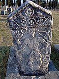
Lukomir sits at an altitude of 1,495 m. on the Bjelašnica mountain. Stećci originating from the 14th and 15th century exist at the village and suggest that it was inhabited for hundreds of years.[2] The homes in the area are made of stone while their roofs are composed of wooden tiles. The Rakitnica canyon is located nearby and is said by local folklore to be the origin of a dragon.[3]
National monument
Considered significant in terms of quality of natural and cultural-historical landscape, Lukomir (Gornji Lukomir) village and its immediate surrounding is designated as National Monument of Bosnia and Herzegovina.[4]
Donji Lukomir

Donji Lukomir (Lower Lukomir) is part of the village situated some 500 meters below Gornji (Upper), on the steep slopes of the Rakitnica canyon.
In film
- Much of the 1990 Yugoslav film Gluvi Barut (Silent Gunpowder) was filmed in Lukomir village and the surrounding Bjelašnica mountain area. [5]
- A documentary entitled Lukomir - Six Months Off (Dutch: Winterslaap in Lukomir) directed by Niels van Koevorden was filmed in 2010. It was screened at the Netherlands Film Festival.[6] It later won the 2010 Documentary Award from Dutch broadcaster VPRO.[7]
- The village appears in the film Killing Season as the birthplace of main character Emil Kovač (played by John Travolta).
- The music video for single "Dođi" (Come) by Bosnian singer-songwriter Dino Merlin and Slovenian singer-songwriter Senidah was filmed in the village in 2020.
Demographics
According to the 2013 census, its population was 13, all Bosniaks.[8]
References
- Bangs, Richard (16 September 2009). "Bosnia: a model for the planet". MSNBC.
- Huseinović, Samir (24 August 2008). "Turizam ni na nebu ni na zemlji". Deutsche Welle (in Serbo-Croatian).
- Šolić, Tomislav. "Posljednja planinska sela Bjelašnice" (in Serbo-Croatian). National Geographic. Archived from the original on 2007-06-10. Retrieved 2012-09-02.
- "Lukomir, cultural landscape - Commission to preserve national monuments". Lukomir-old.kons.gov.ba. 2009. Retrieved 31 May 2018.
- "Gluvi barut". IMDB.
- "Winterslaap in Lukomir". Netherlands Film Festival.
- Sunje, Aida (19 July 2010). "Award Winning Film on Lukomir to Be Screened in Bosnian Village". Balkan Insight.
- "Naseljena Mjesta 1991/2013" (in Bosnian). Statistical Office of Bosnia and Herzegovina. Retrieved October 2, 2021.
Другой контент может иметь иную лицензию. Перед использованием материалов сайта WikiSort.org внимательно изучите правила лицензирования конкретных элементов наполнения сайта.
WikiSort.org - проект по пересортировке и дополнению контента Википедии
