world.wikisort.org - Belgium
Zutendaal, in English sometimes also referred to as Sweet Valley, is a municipality located in the Belgian province of Limburg. On 1 January 2017 Zutendaal had a total population of 7,269. The total area is 32.07 km2, giving a population density of 227 inhabitants per km2.[3]
This article needs additional citations for verification. (January 2013) |
Zutendaal | |
|---|---|
Municipality | |
 Flag  Coat of arms | |
 Zutendaal Location in Belgium | |
| Coordinates: 50°56′N 05°34′E | |
| Country | Belgium |
| Community | Flemish Community |
| Region | Flemish Region |
| Province | Limburg |
| Arrondissement | Hasselt |
| Government | |
| • Mayor | Ann Schrijvers (Nieuw ZVP)[1] |
| • Governing party/ies | Nieuw ZVP, Samen Zutendaal |
| Area | |
| • Total | 32.07 km2 (12.38 sq mi) |
| Population (2018-01-01)[2] | |
| • Total | 7,234 |
| • Density | 230/km2 (580/sq mi) |
| Postal codes | 3690 |
| Area codes | 089 |
| Website | www.zutendaal.be |
In addition to Zutendaal itself, the municipality includes the following population centres: Gewaai, Papendaal, Besmer, Broek, Stalken, Roelen, Daal, and Wiemesmeer.
Etymology
The first written mention of Zutendaal was in 1292 under the name of Suerbroeck, indicating that the land around the village was acidic and swampy. From 1345 the name changed to Zuetendael which literally translates to "Sweet Valley". Indicating there were a lot of freshwater sources around the village.[4]
Demographic evolution
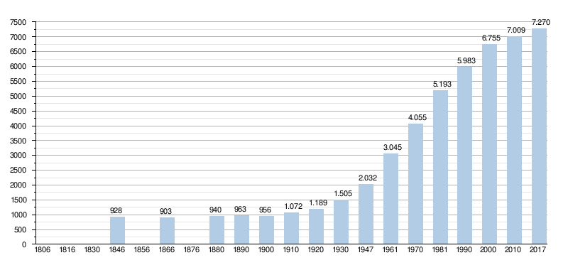
- Bronnen:NIS, Opm:1806 tot en met 1981=volkstellingen; 1990 en later= inwonertal op 1 januari
References
- samenstelling college van burgemeester en schepenen
- "Wettelijke Bevolking per gemeente op 1 januari 2018". Statbel. Retrieved 9 March 2019.
- "Zutendaal | Vlaanderen.be". vlaanderen.be. 27 August 2014.
- "Dialect en namen". users.telenet.be. Retrieved 2017-09-29.
External links
 Media related to Zutendaal at Wikimedia Commons
- Official website - Available only in Dutch
Places adjacent to Zutendaal | ||||||||||||||||
|---|---|---|---|---|---|---|---|---|---|---|---|---|---|---|---|---|
| ||||||||||||||||
Municipalities in the province of Limburg, Flanders, Belgium | ||
|---|---|---|
| Hasselt |
|  |
| Maaseik |
| |
| Tongeren |
| |
| Authority control |
|
|---|
Текст в блоке "Читать" взят с сайта "Википедия" и доступен по лицензии Creative Commons Attribution-ShareAlike; в отдельных случаях могут действовать дополнительные условия.
Другой контент может иметь иную лицензию. Перед использованием материалов сайта WikiSort.org внимательно изучите правила лицензирования конкретных элементов наполнения сайта.
Другой контент может иметь иную лицензию. Перед использованием материалов сайта WikiSort.org внимательно изучите правила лицензирования конкретных элементов наполнения сайта.
2019-2026
WikiSort.org - проект по пересортировке и дополнению контента Википедии
WikiSort.org - проект по пересортировке и дополнению контента Википедии