world.wikisort.org - Belgium
Florenville (French pronunciation: [flɔʁɑ̃vil] (![]() listen); Gaumais: Floravile) is a city and municipality of Wallonia located in the province of Luxembourg, Belgium.
listen); Gaumais: Floravile) is a city and municipality of Wallonia located in the province of Luxembourg, Belgium.
Florenville
Floravile (Gaumais) | |
|---|---|
Municipality | |
 Church of Our Lady of the Assumption | |
 Coat of arms | |
Location of Florenville  | |
 Florenville Location in Belgium
Location of Florenville in Luxembourg province 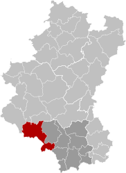 | |
| Coordinates: 49°41.9′N 5°18.6′E | |
| Country | Belgium |
| Community | French Community |
| Region | Wallonia |
| Province | Luxembourg |
| Arrondissement | Virton |
| Government | |
| • Mayor | Caroline Godfrin (MR, Ambition Commune) |
| • Governing party/ies | Ambition commune - Vivr'ensemble |
| Area | |
| • Total | 146.91 km2 (56.72 sq mi) |
| Population (2018-01-01)[1] | |
| • Total | 5,629 |
| • Density | 38/km2 (99/sq mi) |
| Postal codes | 6820-6824 |
| Area codes | 061 |
| Website | www.florenville.be |

On 1 January 2016 the municipality had 5,639 inhabitants. The total area is 146.91 km², giving a population density of 38.38 inhabitants per km².
It is located on the Semois River, facing the French border.
The municipality consists of the following districts: Chassepierre, Florenville, Fontenoille, Lacuisine, Muno, Sainte-Cécile, and Villers-devant-Orval.
Other population centers include: Azy, Conques, Laiche, Martué, Lambermont, Le Ménil, and Watrinsart.
Orval Abbey is located in Villers-devant-Orval.
See also
- List of protected heritage sites in Florenville
References
- Union des Villes et Communes Wallones (in French)
- SPF Economy (in French)
External links
 Media related to Florenville at Wikimedia Commons
- Florenville official website (in French)
Places adjacent to Florenville | ||||||||||||||||
|---|---|---|---|---|---|---|---|---|---|---|---|---|---|---|---|---|
| ||||||||||||||||
Municipalities of the province of Luxembourg, Wallonia | ||
|---|---|---|
| Arlon |  | |
| Bastogne | ||
| Marche-en-Famenne | ||
| Neufchâteau | ||
| Virton | ||
Bold indicates cities | ||
Authority control | |
|---|---|
| General |
|
| National libraries | |
| Other | |
This Belgian Luxembourg location article is a stub. You can help Wikipedia by expanding it. |
- "Wettelijke Bevolking per gemeente op 1 januari 2018". Statbel. Retrieved 9 March 2019.
На других языках
[de] Florenville
Florenville ist eine Gemeinde mit etwa 5500 Einwohnern im Südosten von Belgien in der Wallonischen Region. Die Stadt liegt auf einer Anhöhe, am Ufer der Semois (deutsch Sesbach).- [en] Florenville
[ru] Флоранвиль
Флоранви́ль — коммуна в Валлонии, расположенная в провинции Люксембург, округ Виртон. Принадлежит Французскому языковому сообществу Бельгии. На площади 146,91 км² проживают 5449 человек (плотность населения — 37 чел./км²), из которых 49,29 % — мужчины и 50,71 % — женщины. Средний годовой доход на душу населения в 2003 году составлял 10 242 евро.Другой контент может иметь иную лицензию. Перед использованием материалов сайта WikiSort.org внимательно изучите правила лицензирования конкретных элементов наполнения сайта.
WikiSort.org - проект по пересортировке и дополнению контента Википедии