world.wikisort.org - Austria
Sankt Margareten im Rosental (Slovene: Šmarjeta v Rožu) is a town in the district of Klagenfurt-Land in the Austrian state of Carinthia.
Sankt Margareten im Rosental
Šmarjeta v Rožu | |
|---|---|
 | |
 Coat of arms | |
 Sankt Margareten im Rosental Location within Austria | |
| Coordinates: 46°33′N 14°25′E | |
| Country | Austria |
| State | Carinthia |
| District | Klagenfurt-Land |
| Government | |
| • Mayor | Lukas Wolte |
| Area | |
| • Total | 43.99 km2 (16.98 sq mi) |
| Elevation | 607 m (1,991 ft) |
| Population (2018-01-01)[2] | |
| • Total | 1,099 |
| • Density | 25/km2 (65/sq mi) |
| Time zone | UTC+1 (CET) |
| • Summer (DST) | UTC+2 (CEST) |
| Postal code | 9173 |
| Area code | 04226 |
| Website | www.st-margareten.at |
Geography
The municipality lies in the southeast Rosental at the foot of the Hochobir. On the north, the Drau forms the municipal boundary, on the east the Freibach, and on the south and the west tributaries of the Karawank and the Inzegraben.
Population
According to the 2001 census 11,8% of the population are Carinthian Slovenes.
| Village | Number of people 1991 | Percent of Slovenes 1991 | Percent of Slovenes 1951 |
|---|---|---|---|
| Trieblach/Treblje | 92 | 35,3% | 56,2% |
| Gupf/Vrh | 85 | 15,3% | 85,1% |
| Niederdörfl/Doljna vas | 184 | 19,6% | 84,9% |
| St.Margarethen/Šmarjeta | 274 | 16,1% | 59,6% |
| Homölisch/Hmelše | 9 | 33,3% | 98,1% |
| Gotschuchen/Kočuha | 221 | 15,4% | 79,1% |
| Sabosach/Zavoze | 47 | 25,5% | 55,2% |
| Seel/Selo | 30 | 33,3% | 50,0% |
| Dobrowa/Dobrava | 33 | 21,2% | 91,5% |
| Hintergupf/Zavrh | 34 | 19,4% | 100% |
| Dullach/Dole | 56 | 5,4% | 95,1% |
| Oberdörfl/Gornja vas | 88 | 5,0% | 23,2% |
Notable people
- Karl Matthäus Woschitz (b. 1937), theologian and bible scholar
District Klagenfurt Land
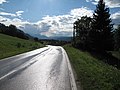 Between Sankt Margarethen and Oberdörfl, road panorama
 Between Oberdörfl and Abtei, panorama


References
- "Dauersiedlungsraum der Gemeinden Politischen Bezirke und Bundesländer - Gebietsstand 1.1.2018". Statistics Austria. Retrieved 10 March 2019.
- "Einwohnerzahl 1.1.2018 nach Gemeinden mit Status, Gebietsstand 1.1.2018". Statistics Austria. Retrieved 9 March 2019.
Wikimedia Commons has media related to Sankt Margareten im Rosental.
This Carinthia location article is a stub. You can help Wikipedia by expanding it. |
На других языках
[de] Sankt Margareten im Rosental
Sankt Margareten im Rosental, amtlich St. Margareten im Rosental (slowenisch: Šmarjeta v Rožu), ist eine zweisprachige[1][2] Gemeinde mit 1092 Einwohnern (Stand 1. Jänner 2022) im Bezirk Klagenfurt-Land in Kärnten.- [en] Sankt Margareten im Rosental
[ru] Санкт-Маргаретен-им-Розенталь
Санкт-Маргаретен-им-Розенталь (нем. Sankt Margareten im Rosental) — коммуна (нем. Gemeinde) в Австрии, в федеральной земле Каринтия.Текст в блоке "Читать" взят с сайта "Википедия" и доступен по лицензии Creative Commons Attribution-ShareAlike; в отдельных случаях могут действовать дополнительные условия.
Другой контент может иметь иную лицензию. Перед использованием материалов сайта WikiSort.org внимательно изучите правила лицензирования конкретных элементов наполнения сайта.
Другой контент может иметь иную лицензию. Перед использованием материалов сайта WikiSort.org внимательно изучите правила лицензирования конкретных элементов наполнения сайта.
2019-2025
WikiSort.org - проект по пересортировке и дополнению контента Википедии
WikiSort.org - проект по пересортировке и дополнению контента Википедии