world.wikisort.org - Austria
Sankt Gotthard im Mühlkreis is a municipality in the district of Urfahr-Umgebung in Upper Austria, Austria.
This article may be expanded with text translated from the corresponding article in German. (November 2016) Click [show] for important translation instructions.
|
Sankt Gotthard im Mühlkreis | |
|---|---|
 | |
 Coat of arms | |
 Sankt Gotthard im Mühlkreis Location within Austria | |
| Coordinates: 48°22′10″N 14°07′02″E | |
| Country | Austria |
| State | Upper Austria |
| District | Urfahr-Umgebung |
| Government | |
| • Mayor | Johannes Rechberger (ÖVP) |
| Area | |
| • Total | 11.99 km2 (4.63 sq mi) |
| Elevation | 473 m (1,552 ft) |
| Population (2018-01-01)[2] | |
| • Total | 1,332 |
| • Density | 110/km2 (290/sq mi) |
| Time zone | UTC+1 (CET) |
| • Summer (DST) | UTC+2 (CEST) |
| Postal code | 4112 |
| Area code | 0 72 34 |
| Vehicle registration | UU |
| Website | www.sanktgotthard.at |
Attractions include Schloss Eschelberg, a stately home built in 1596, and the ruined 13th century Rottenegg Castle.[3]
Villages
The municipality contains the following villages:
- Eschelberg
- Grasbach
- Haselwies
- Maierleiten
- Mühlholz
- Oberstraß
- Rottenegg
Population
| Year | Pop. | ±% |
|---|---|---|
| 1869 | 779 | — |
| 1890 | 790 | +1.4% |
| 1910 | 756 | −4.3% |
| 1923 | 761 | +0.7% |
| 1934 | 742 | −2.5% |
| 1939 | 688 | −7.3% |
| 1951 | 966 | +40.4% |
| 1971 | 975 | +0.9% |
| 1991 | 1,125 | +15.4% |
| 2001 | 1,299 | +15.5% |
| 2007 | 1,314 | +1.2% |
Gallery
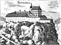 Rottenegg Castle, now ruined
 Schloss Eschelberg, built in 1596
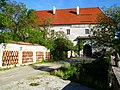 Schloss Eschelberg forest house
 Medieval mill house
 Former prison


References
- "Dauersiedlungsraum der Gemeinden Politischen Bezirke und Bundesländer - Gebietsstand 1.1.2018". Statistics Austria. Retrieved 10 March 2019.
- "Einwohnerzahl 1.1.2018 nach Gemeinden mit Status, Gebietsstand 1.1.2018". Statistics Austria. Retrieved 9 March 2019.
- "Oberösterreich unbewegliche und archäologische Denkmale unter Denkmalschutz" (PDF). Bundesdenkmalamtes Österreich. 28 June 2013. p. 136.
| Wikimedia Commons has media related to Sankt Gotthard im Mühlkreis. |
Authority control | |
|---|---|
| General |
|
| National libraries | |
This Upper Austria location article is a stub. You can help Wikipedia by expanding it. |
На других языках
- [en] Sankt Gotthard im Mühlkreis
[ru] Санкт-Готтхард-им-Мюлькрайс
Санкт-Готтхард-им-Мюлькрайс (нем. Sankt Gotthard im Mühlkreis) — община (нем. Gemeinde) в Австрии, в федеральной земле Верхняя Австрия.Текст в блоке "Читать" взят с сайта "Википедия" и доступен по лицензии Creative Commons Attribution-ShareAlike; в отдельных случаях могут действовать дополнительные условия.
Другой контент может иметь иную лицензию. Перед использованием материалов сайта WikiSort.org внимательно изучите правила лицензирования конкретных элементов наполнения сайта.
Другой контент может иметь иную лицензию. Перед использованием материалов сайта WikiSort.org внимательно изучите правила лицензирования конкретных элементов наполнения сайта.
2019-2026
WikiSort.org - проект по пересортировке и дополнению контента Википедии
WikiSort.org - проект по пересортировке и дополнению контента Википедии