world.wikisort.org - Austria
Bruck an der Leitha (Central Bavarian: Bruck aun da Leitha; "Bridge on the Leitha") is a city in Lower Austria, Austria at the border to the Burgenland, which is marked by the Leitha river.
This article needs additional citations for verification. (June 2016) |
Bruck an der Leitha | |
|---|---|
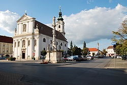
 Main square with the parish church | |
 Coat of arms | |
 Bruck an der Leitha Location within Austria | |
| Coordinates: 48°1′N 16°46′E | |
| Country | Austria |
| State | Lower Austria |
| District | Bruck an der Leitha |
| Government | |
| • Mayor | Gerhard Weil (SPÖ) |
| Area | |
| • Total | 23.69 km2 (9.15 sq mi) |
| Elevation | 156 m (512 ft) |
| Population (2018-01-01)[2] | |
| • Total | 7,988 |
| • Density | 340/km2 (870/sq mi) |
| Time zone | UTC+1 (CET) |
| • Summer (DST) | UTC+2 (CEST) |
| Postal code | 2460 |
| Area code | 02162 |
| Website | www.bruckleitha.at |
In and around Bruck parts of neolithic tools were found, which makes it likely that there was a settlement there at that time. In Roman time, there was the crossing of two major roads, one of them being the Amber Road, the other a link to the Via Militaris. The important Roman army camp Carnuntum was located only ten miles northeast of Bruck at the Amber Road. In Bruck a Roman fortification is said to have been at the place of "Schloss Prugg" (castle of Duke Harrach), of which one part still is named "Roman Tower" (though being built in the Middle Ages).
After the end of the Roman Empire, the first traces of new settlement date from around 900. Graves from this time show Hungarian and later Francian/Bavarian influence. In 1074 the settlement is first documented as "Aschirichesprucca" and elevated to the status of a city in 1239. During the 13th century Bruck was rebuilt according to a rectangular street-scheme north-east of the old settlement.
Though quite strongly fortified since, Bruck never played an important role in a military conflict. In the long period of wars with the Turkish Empire the fortifications were already outdated, so Bruck did not even try to resist Turkish troops when they approached Vienna in 1529 and 1683 (Siege of Vienna). Therefore, Bruck was not destroyed (unlike other towns like Hainburg).
After this period, Bruck prospered and became an important center of wine production and trade. In the Napoleonic Wars Bruck was a center of maneuvers for the Austrian army, which it remained during the 19th century. In 1867 an important permanent military base was erected. After the end of World War I in 1918 the Austro-Hungarian Empire broke up. Most of Bruck belonged to Austria, but the military base and the main railway station was situated on the Hungarian side of the border (this part of Bruck is called Bruckneudorf).
In 1921, when the western parts of Hungary were integrated to Austrian territory under the name of "Burgenland", Bruck remained divided between the provinces of Lower Austria and Burgenland. Bruck an der Leitha became the capital of the same-named district. Despite the important military base neighbouring Bruck, the town was not much affected by World War II. Today, Bruck has about 7300 inhabitants and still is the administrative center of the district. Important sights are the city walls from the 13th century, the Baroque church and the old castle, Schloss Prugg, of the Dukes of Harrach.
Today, the town is prospering in the energy department. It has nearby a large wind farm (possibly 60MW), which generates all the electricity for the town. In fact, the wind farm produces more energy than the town consumes, so the town profits off it through energy sales.
Subdivisions
- Bruck an der Leitha: 14,78 km²
- Schloss Prugg (de): 0,71 km²
- Wilfleinsdorf (de): 8,32 km²
People
- Otto Tschadek (de)
- Oskar Helmer (de)
- Johann-Nepomuk Kral
- Leopold Petznek (de)
- Josef Ernst Köpplinger (de)
- Alfred Anton Ruscher, Österreichischer Eisenbahnpionier der k.k. Staatsbahnen (de)
- Anton Stadler, clarinettist (de)
- Johann Stadler, clarinettist
- Johannes Huber, doctor, theologian (de)
See also
- Bruck·neudorf (there is the Bruck an der Leitha station), now Neusiedl am See District, Burgenland
- Transleithania
References
- "Dauersiedlungsraum der Gemeinden Politischen Bezirke und Bundesländer - Gebietsstand 1.1.2018". Statistics Austria. Retrieved 10 March 2019.
- "Einwohnerzahl 1.1.2018 nach Gemeinden mit Status, Gebietsstand 1.1.2018". Statistics Austria. Retrieved 9 March 2019.
На других языках
[de] Bruck an der Leitha
Bruck an der Leitha (ungarisch Lajtabruck, slowakisch und tschechisch Most nad Litavou) ist eine österreichische Stadt mit 8186 Einwohnern (Stand 1. Jänner 2022) an der Leitha im Bezirk Bruck an der Leitha in Niederösterreich. Bruck an der Leitha ist gleichzeitig Sitz der Bezirkshauptmannschaft des gleichnamigen Bezirkes.- [en] Bruck an der Leitha
[ru] Брукк-ан-дер-Лайта
Брукк-ан-дер-Ла́йта[1] (часто также Брук-ан-дер-Лайта или Брук-на-Лайте, нем. Bruck an der Leitha) — окружной центр в Австрии, в федеральной земле Нижняя Австрия. В прошлом — резиденция графов Гаррахов[2].Другой контент может иметь иную лицензию. Перед использованием материалов сайта WikiSort.org внимательно изучите правила лицензирования конкретных элементов наполнения сайта.
WikiSort.org - проект по пересортировке и дополнению контента Википедии