world.wikisort.org - Australia
Wyandra is a town and a locality in the Shire of Paroo, Queensland, Australia.[2][3] In the 2016 census, Wyandra had a population of 99 people.[1]
| Wyandra Queensland | |||||||||||||||
|---|---|---|---|---|---|---|---|---|---|---|---|---|---|---|---|
 Wyandra General Store, 2009 | |||||||||||||||
 Wyandra | |||||||||||||||
| Coordinates | 27.2463°S 145.9783°E | ||||||||||||||
| Population | 99 (2016 census)[1] | ||||||||||||||
| • Density | 0.01953/km2 (0.05058/sq mi) | ||||||||||||||
| Postcode(s) | 4489 | ||||||||||||||
| Area | 5,069.5 km2 (1,957.3 sq mi) | ||||||||||||||
| Time zone | AEST (UTC+10) | ||||||||||||||
| Location |
| ||||||||||||||
| LGA(s) | Paroo Shire | ||||||||||||||
| State electorate(s) | Warrego | ||||||||||||||
| Federal division(s) | Maranoa | ||||||||||||||
| |||||||||||||||
Geography
The Warrego River flows from north to south through the locality. The Mitchell Highway also passes from north to south through the locality to the east and roughly parallel with the river. The town is in roughly the centre of the locality just to the east of the river and west of the highway, 827 kilometres (514 mi) west of the state capital, Brisbane and 110 kilometres (68 mi) north of Cunnamulla.[4]
History

The town was originally named Claverton in July 1896, after the Claverton Downs pastoral run on the Warrego River, which was established about 1860. However, it was renamed Wyandra later in 1896.[2][5]
The town grew with the completion of the Western railway line from Charleville in 1897 and quickly became a centre for local grazing properties.
The Wyandra Provisional School opened on 10 February 1898 and became Wyandra State School on 1 January 1909.[6]
In February 1921, the citizens of Wyandra erected a war memorial on the corner of Macks and Warrego Streets in honour of those residents of the district who served in the military during World War I. The memorial has a digger statue and lists the names of the 23 who enlisted and commemorates the three who died.[7][8]
A powerhouse was established in 1955 with generators that came from Cunnamulla. Wyandra was connected to the state electricity grid in 1970. The obsolete powerhouse was placed on Standby and later converted into a museum.[5]
At the 2006 census had a population of 116.[9]
Media
Wyandra is home to the following radio stations:
- ABC Radio Western Queensland – 603 AM
- 4VL (Resonate Radio) – 93.9 FM
- ABC Radio National – 106.1 FM
The Australian Broadcasting Corporation transmits ABQ and its sister Channels, ABC Kids, ABC TV Plus, ABC Me and ABC NEWS to Wyandra through its Cunnamulla relay station, ABCAQ, situated at 28°2′54″S 145°42′6″E
The Seven Network and its sister channels 7Two, 7Mate and 7Flix transmit to Wyandra through its regional area affiliate, ITQ.
Network Ten and its sister channels 10 Bold, 10 Peach and 10 Shake transmit to Wyandra through its regional area affiliate, CDT
The Nine Network and its sister channels 9Gem, 9Go! and 9Rush transmit to Wyandra through its regional area affiliate, Imparja Television
The Special Broadcasting Service and its sister channels SBS Viceland, SBS World Movies and SBS Food also transmit to Wyandra.
Facilities
Paroo Shire Council operates Wyandra Library at Macks Street.[10]
Wyandra has the Powerhouse Museum. The Wyandra hall has a park behind the hall and public toilets in front of the hall. There is a free caravan park behind school.[5]
Education
Wyandra State School is a government primary (Early Childhood-6) school for boys and girls at Moody Street (27.2454°S 145.9779°E).[11][12] In 2017, the school had an enrolment of 4 students with 1 teacher and 2 non-teaching staff (1 full-time equivalent).[13]
There is no secondary school in Wyandra; the nearest secondary schools are Charleville State High School in Charleville and Cunnamulla P-12 State School in Cunnamulla (both approximately 125 kilometres (78 mi) away).[4]
References
- Australian Bureau of Statistics (27 June 2017). "Wyandra (SSC)". 2016 Census QuickStats. Retrieved 20 October 2018.
- "Wyandra – town in Shire of Paroo (entry 43475)". Queensland Place Names. Queensland Government. Retrieved 9 April 2019.
- "Wyandra – locality in Shire of Paroo (entry 42663)". Queensland Place Names. Queensland Government. Retrieved 9 April 2019.
- "Queensland Globe". State of Queensland. Retrieved 8 April 2019.
- "Wyandra". Cunnamulla Tourist Information. Archived from the original on 12 November 2013. Retrieved 12 November 2013.
- Queensland Family History Society (2010), Queensland schools past and present (Version 1.01 ed.), Queensland Family History Society, ISBN 978-1-921171-26-0
- "WYANDRA'S TRIBUTE". Darling Downs Gazette. No. 9301. Queensland, Australia. 18 February 1921. p. 4. Retrieved 11 April 2019 – via National Library of Australia.
- "Wyandra War Memorial (Digger)". Queensland War Memorial Register. Archived from the original on 11 April 2019. Retrieved 11 April 2019.
- Australian Bureau of Statistics (25 October 2007). "Wyandra (Paroo Shire) (State Suburb)". 2006 Census QuickStats. Retrieved 28 October 2007.
- "Wyandra Library". Public Libraries Connect. State Library of Queensland. Archived from the original on 2 January 2018. Retrieved 23 January 2018.
- "State and non-state school details". Queensland Government. 9 July 2018. Archived from the original on 21 November 2018. Retrieved 21 November 2018.
- "Wyandra State School". Archived from the original on 26 March 2012. Retrieved 21 November 2018.
- "ACARA School Profile 2017". Archived from the original on 22 November 2018. Retrieved 22 November 2018.
Further reading
- Brayley, Annabelle; Wyandra Centenary Committee (1997). Paddock to the pub : Wyandra and district – past 100 years : a collection of memories. Wyandra Centenary Committee. ISBN 978-0-646-31860-8.
External links
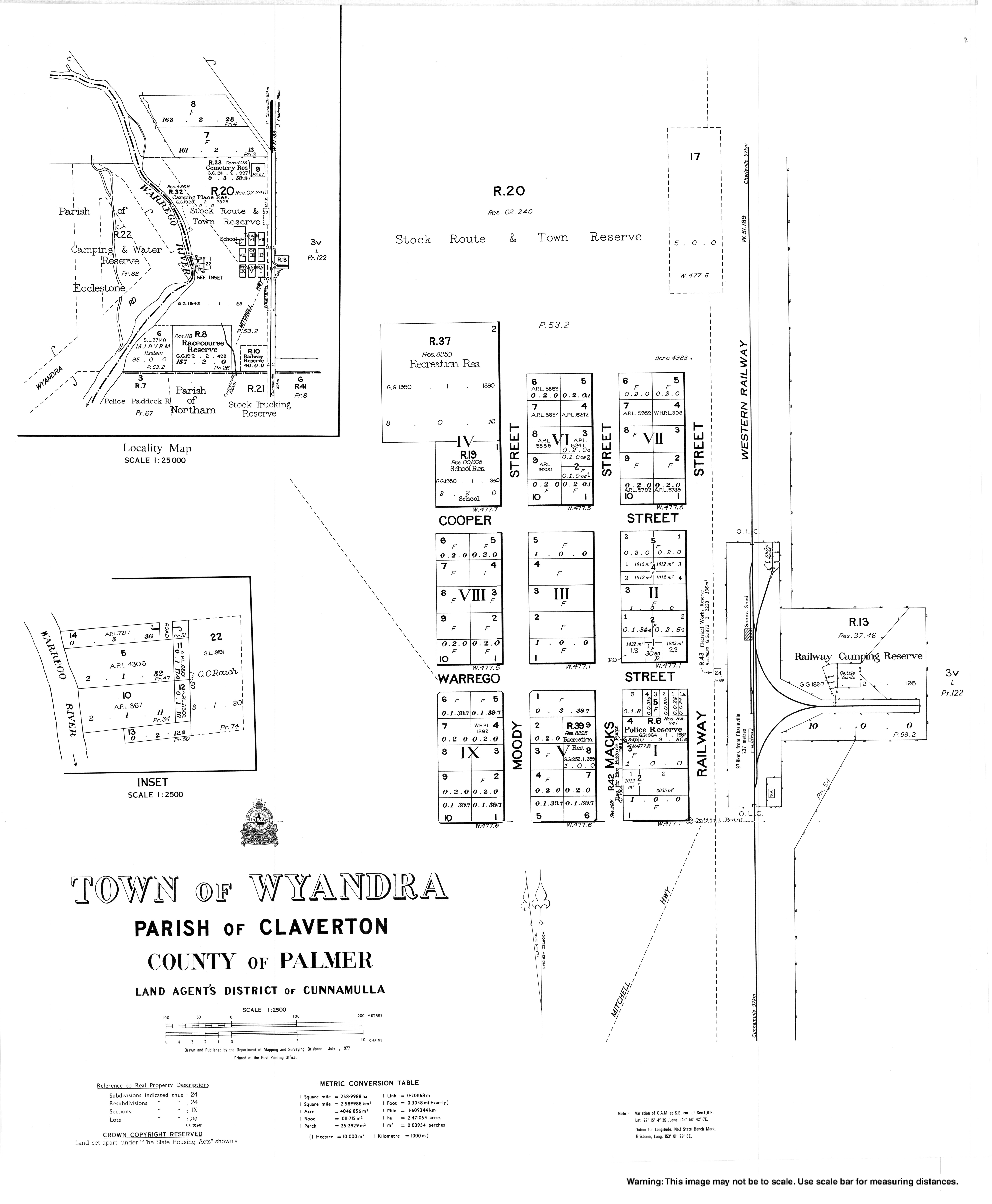
- Town map of Wyandra, 1977
- Paroo Shire Council – Wyandra – Official website
- Community website
- Images available on Google
Другой контент может иметь иную лицензию. Перед использованием материалов сайта WikiSort.org внимательно изучите правила лицензирования конкретных элементов наполнения сайта.
WikiSort.org - проект по пересортировке и дополнению контента Википедии