world.wikisort.org - Australia
The Summit is a rural town and locality in the Southern Downs Region, Queensland, Australia.[2][3] In the 2016 census, the locality of The Summit had a population of 409 people.[1]
| The Summit Queensland | |||||||||||||||
|---|---|---|---|---|---|---|---|---|---|---|---|---|---|---|---|
 Granite Belt Drive (main street), The Summit, 2015 | |||||||||||||||
 The Summit | |||||||||||||||
| Coordinates | 28.5755°S 151.9508°E | ||||||||||||||
| Population | 409 (2016 census)[1] | ||||||||||||||
| • Density | 24.79/km2 (64.20/sq mi) | ||||||||||||||
| Postcode(s) | 4377 | ||||||||||||||
| Elevation | 923.5 m (3,030 ft) | ||||||||||||||
| Area | 16.5 km2 (6.4 sq mi) | ||||||||||||||
| Time zone | AEST (UTC+10:00) | ||||||||||||||
| Location |
| ||||||||||||||
| LGA(s) | Southern Downs Region | ||||||||||||||
| State electorate(s) | Southern Downs | ||||||||||||||
| Federal division(s) | Maranoa | ||||||||||||||
| |||||||||||||||
The locality borders New South Wales.[4]
Geography
The Summit is predominantly farmland with some urban development surrounding the railway station. The New England Highway passes north-south through the town, running close to and parallel with the Southern railway line. Originally the highway was the main street of the town, but now the highway bypasses the town to the east. Cannon Creek forms the south-western border of the locality.[4]
History

The town takes its name from The Summit railway station, which was so named because it was the highest point (923.5 metres (3,030 ft)) on the Southern railway line from Warwick to Wallangarra.[5]
The Summit State School opened on 29 August 1921.[6][7]
The Summit Methodist Church opened on Wednesday 18 August 1915.[8] Following the amalgamation of the Methodist Church into the Uniting Church in Australia in 1977, it became The Summit Uniting Church. It closed on 18 November 2017. It was at 9 Church Road (28.5773°S 151.9491°E). The church building is still extant, but has been converted into a house.[9][10][11]
On Sunday 28 November 1926, St John's Anglican Church was officially opened and dedicated by Reverend Canon David Garland.[12][13]
The Seventh-Day Adventist Church opened in 1989.[14]
In the 2011 census, the locality of The Summit had a population of 484 people.[15]
In the 2016 census, the locality of The Summit had a population of 409 people.[1]
Education

The Summit State School is a government primary (Prep-6) school for boys and girls at Taggart's Road (28.5790°S 151.9552°E).[16][17] In 2018, the school had an enrolment of 31 students with 3 teachers (2 full-time equivalent) and 7 non-teaching staff (3 full-time equivalent).[18]
There is no secondary school in The Summit. The nearest government secondary school is Stanthorpe State High School in Stanthorpe to the south.[4]
Amenities

The Summit Public Hall is at 101 Granite Belt Drive (28.5745°S 151.9490°E) opposite the railway station.[19]
St John's Anglican Church is at 7 Teale Road (28.5741°S 151.9484°E). It is part of the Stanthorpe Parish within the Anglican Diocese of Brisbane.[20][21][22]
The Summit Seventh Day Adventist Church is at 25 Church Road (28.5773°S 151.9475°E).[23][14][24]
References
- Australian Bureau of Statistics (27 June 2017). "The Summit (SSC)". 2016 Census QuickStats. Retrieved 20 October 2018.
- "The Summit – town in Southern Downs Region (entry 34150)". Queensland Place Names. Queensland Government. Retrieved 29 December 2020.
- "The Summit – locality in Southern Downs Region (entry 45992)". Queensland Place Names. Queensland Government. Retrieved 29 December 2020.
- "Queensland Globe". State of Queensland. Retrieved 25 January 2022.
- "The Summit – railway station in the Southern Downs Region (entry 34151)". Queensland Place Names. Queensland Government. Retrieved 25 January 2022.
- "Opening and closing dates of Queensland Schools". Queensland Government. Retrieved 10 June 2015.
- "Agency ID 11258, The Summit State School". Queensland State Archives. Retrieved 11 June 2015.
- "COUNTRY TELEGRAMS". The Brisbane Courier. No. 17, 977. Queensland, Australia. 28 August 1915. p. 16. Archived from the original on 25 January 2022. Retrieved 25 January 2022 – via National Library of Australia.
- "The Summit Uniting Church - Former". Churches Australia. Archived from the original on 25 January 2022. Retrieved 25 January 2022.
- Google (25 January 2022). "The Summit Methodist Church (former)" (Map). Google Maps. Google. Retrieved 25 January 2022.
- Blake, Thom. "The Summit Methodist Church". Queensland religious places database. Archived from the original on 25 January 2022. Retrieved 25 January 2022.
- "CHURCH OF ENGLAND". Warwick Daily News. No. 2417. Queensland, Australia. 30 November 1926. p. 3. Archived from the original on 25 January 2022. Retrieved 25 January 2022 – via National Library of Australia.
- Blake, Thom. "St John's Anglican Church". Queensland religious places database. Archived from the original on 25 January 2022. Retrieved 25 January 2022.
- Blake, Thom. "Seventh Day Adventist Church". Queensland religious places database. Archived from the original on 25 January 2022. Retrieved 25 January 2022.
- Australian Bureau of Statistics (31 October 2012). "The Summit (SSC)". 2011 Census QuickStats. Retrieved 11 June 2015.
- "State and non-state school details". Queensland Government. 9 July 2018. Archived from the original on 21 November 2018. Retrieved 21 November 2018.
- "The Summit State School". The Summit State School. 3 April 2020. Archived from the original on 13 March 2021. Retrieved 25 January 2022.
- "ACARA School Profile 2018". Australian Curriculum, Assessment and Reporting Authority. Archived from the original on 27 August 2020. Retrieved 28 January 2020.
- Google (25 January 2022). "The Summit Public Hall" (Map). Google Maps. Google. Retrieved 25 January 2022.
- "Contact Us | Stanthorpe Anglican Parish | Queensland". Stanthorpe Anglican. Archived from the original on 16 April 2021. Retrieved 25 January 2022.
- Google (25 January 2022). "St John's Anglican Church" (Map). Google Maps. Google. Retrieved 25 January 2022.
- "St John's Anglican Church". Churches Australia. Archived from the original on 25 January 2022. Retrieved 25 January 2022.
- "The Summit Adventist Church". The Summit Adventist Church. Archived from the original on 5 March 2021. Retrieved 25 January 2022.
- "The Summit, Seventh-Day Adventist Church". Churches Australia. Archived from the original on 27 October 2020. Retrieved 25 January 2022.
Further reading
External links
| Wikimedia Commons has media related to The Summit, Queensland. |
- "Amiens, Thulimbah, Applethorpe District". Queensland Places. Centre for the Government of Queensland, University of Queensland.
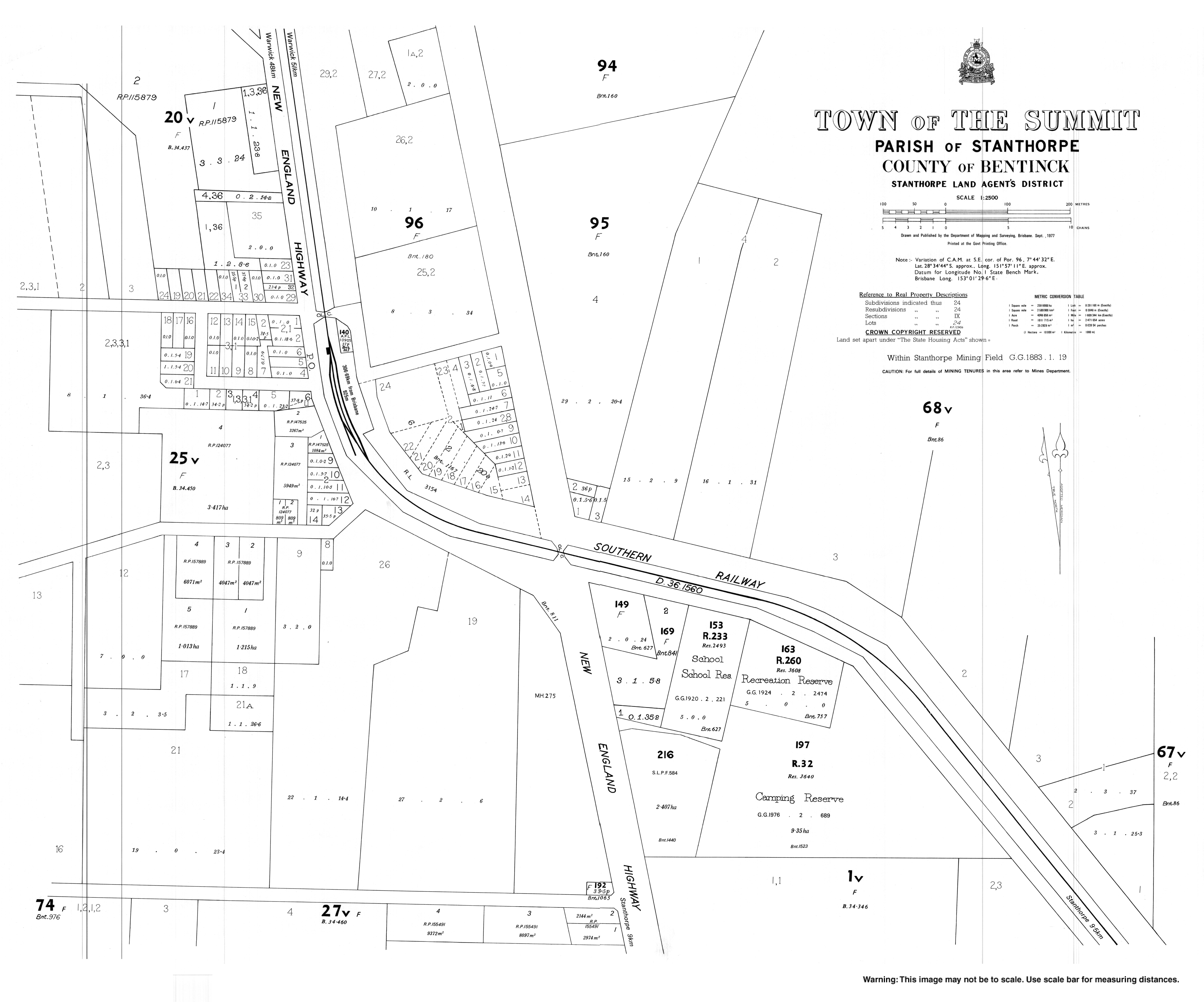
- Town map of The Summit, 1977
Другой контент может иметь иную лицензию. Перед использованием материалов сайта WikiSort.org внимательно изучите правила лицензирования конкретных элементов наполнения сайта.
WikiSort.org - проект по пересортировке и дополнению контента Википедии