world.wikisort.org - Australia
Port Macquarie is a coastal town[2][3] in the local government area of Port Macquarie-Hastings. It is located on the Mid North Coast of New South Wales, Australia, about 390 km (242 mi) north of Sydney, and 570 km (354 mi) south of Brisbane. The town is located on the Tasman Sea coast, at the mouth of the Hastings River, and at the eastern end of the Oxley Highway (B56). The town with its suburbs had a population of 47,973 in June 2018.[1]
| Port Macquarie New South Wales | |||||||||
|---|---|---|---|---|---|---|---|---|---|
Clockwise from top: Lighthouse Beach; Tacking Point Lighthouse; intersection of Clarence & Horton Streets, featuring Majestic Cinemas in the Ritz Centre | |||||||||
Port Macquarie Location in New South Wales | |||||||||
| Coordinates | 31°26′S 152°54′E | ||||||||
| Population | 47,973 (2018)[1] | ||||||||
| Postcode(s) | 2444 | ||||||||
| Elevation | 5 m (16 ft) | ||||||||
| Location | |||||||||
| LGA(s) | Port Macquarie-Hastings Council | ||||||||
| County | Macquarie | ||||||||
| Parish | Macquarie | ||||||||
| State electorate(s) | Port Macquarie | ||||||||
| Federal division(s) | Cowper | ||||||||
| |||||||||


History
This section needs additional citations for verification. (February 2017) |
Port Macquarie sits within Birpai (Biripi, Birripai, Bripi, Biripai, Birrbay) country, and the Birpai people are recognised as the traditional custodians of the land on which Port Macquarie is located.[4] Port Macquarie was long known to the Birpai people as Guruk.[5] The Birpai Local Aboriginal Land Council provides positive support, information and responsible governance for the Aboriginal community, while also cultivating strong links with the broader community.[6][failed verification]
The site of Port Macquarie was first visited by Europeans in 1818 when John Oxley reached the Pacific Ocean from the interior, after his journey to explore inland New South Wales. He named the location after the Governor of New South Wales, Lachlan Macquarie.
Oxley noted that "the port abounds with fish, the sharks were larger and more numerous than I have ever before observed. The forest hills and rising grounds abounded with large kangaroos and the marshes afford shelter and support to innumerable wildfowl. Independent of the Hastings River, the area is generally well watered, there is a fine spring at the very entrance to the Port."
In 1821, Port Macquarie was founded as a penal settlement, replacing Newcastle as the destination for convicts who had committed secondary crimes in New South Wales. Newcastle, which had fulfilled this role for the previous two decades, had lost the features required for a place for dumping irredeemable criminals, that being isolation, which was lost as the Hunter Region was opened up to farmers, and large amounts of hard labor, which had diminished as the cedar in the area ran out and the settlement grew in size. Port Macquarie, however, with its thick bush, tough terrain and local aboriginals that were keen to return escaping prisoners in return for tobacco and blankets, provided large amounts of both isolation and hard labour to keep the criminals in control. Under its first commandant, Francis Allman, who was fond of flogging, the settlement became a hell, where the convicts had limited liberties, especially in regard to being in possession of letters and writing papers, which could get a convict up to 100 lashes.
The penal settlement lasted from April 1820 to c. 15 August 1830. The settlement peaked with 1500 convicts by 1825 but by 1828 this had fallen to 530. The commanders of the settlement were:
- Francis Allman, March 1821–1824
- Captain Rolland succeeded Allman in April 1824
- Lieutenant Carmac, 1824
- Henry Gillman in January 1824–
- Archibald Clunes Innes 1826–1827
Because of the lack of liberties of the settlement, Governor Ralph Darling quickly sent there many 'specials' or literate convicts with a decent education who had voiced negative views about him. Later on in the settlement's history, in the 1830s, disabled convicts started to arrive. One-armed men would be grouped together and required to break stones, men with wooden legs would become delivery men, and the blind would often be given tasks during the night which they performed more skilfully than those with sight.[7]

In 1823 the first sugar cane to be cultivated in Australia was planted there. The region was first opened to settlers in 1830 and later on in the decade the penal settlement was closed in favour of a new penal settlement at Moreton Bay. Settlers quickly took advantage of the area's good pastoral land, timber resources and fisheries.

St Thomas's Anglican Church is a Georgian building designed by Francis Greenway and built, under the supervision of military engineer Lieutenant T. Owen, by convicts from 1824 to 1828. This church is among the oldest in Australia and one of the few remaining convict-built churches. Inside there are red cedar box pews that were peculiar to that period in church architecture.[8] The Walker pipe organ is the only one of its type in the southern hemisphere. The castellated tower permits excellent views of the coastline, town and river. This church is now classified by the National Trust of Australia (NSW) and has been registered on the National Estate heritage list.
In 1830 Major Archibald Clunes Innes built Lake Innes House which grew over the next decade into a luxurious establishment and attracted many notable visitors. It is now a ruin and is managed by the NSW Parks and Wildlife Service.
In 1840 the "Wool Road" from the Northern Tablelands was under construction to enable wool and other produce to be shipped from the port. Port Macquarie was declared a municipality in 1887, but the town never progressed as a port owing to a notorious coastal bar across the mouth of the river.
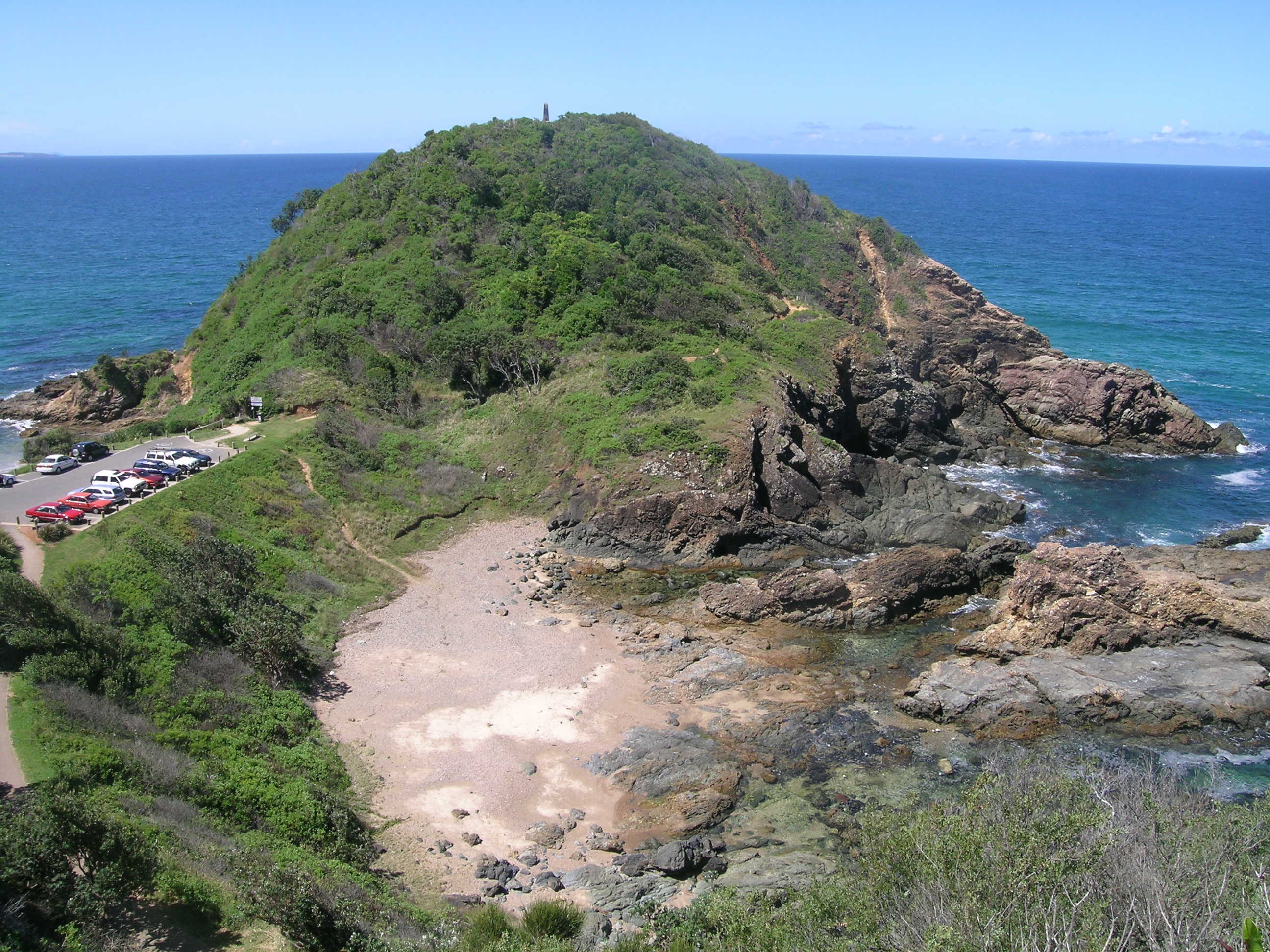
Over 20 shipwrecks occurred in the Tacking Point area before a lighthouse was designed by James Barnet and erected there in 1879 by Shepard and Mortley. Tacking Point Lighthouse is classified by the National Trust of Australia (NSW).
Writer Louis Becke was born and grew up in the town in the 1860s and later recalled those days, saying Port Macquarie was an,
old-time town ... a quaint, sleepy little place of six hundred inhabitants, who spend their days in fishing and waiting for better times. There are two or three fairly good hotels, very pretty scenery along the coast and up the river, and a stranger can pass a month without suffering from ennui – that is, of course, if he is fond of fishing and shooting; if he is not, he should avoid going there, for it is the dullest coast town in New South Wales.[9]
In the 1970s, Grace Easterbrook, a retired secretary from Scotland, began a campaign against the high-rise developments which were multiplying up the coast. She led a group of citizen activists in lobbying against a large development on Windmill Hill and other efforts to conserve the coast.[10] In 1974, residents of Port Macquarie requested that the Builders Labourers Federation place a green ban against the construction of high rise buildings on beach head and water front.[11] Easterbrook died in 1984, before the culmination of her conservation efforts, the beautiful coastal walks, were completed.[10]
Severe flooding occurred in March 2021 when the Hastings River flooded during a severe weather event affecting much of New South Wales.[12]
Heritage listings
Port Macquarie has a number of heritage-listed sites, including:
- Port Macquarie First Burying Ground[13]
- Port Macquarie Government House Site[14]
- Hastings Historical Society Museum[15]
- Overseers' Cottages Remains[16]
- Old Port Macquarie Courthouse[17]
- Port Macquarie Second Burying Ground[18]
- St Thomas Anglican' Church[19]
- Lake Innes House Ruins[20]
Population
In 1847, the population was 819, of whom 599 were males and 220 were female.[21] The gender disparity was probably due to the penal station there at the time.
The estimated urban population of Port Macquarie was 47,973 as at June 2018,[1] having grown 1.8% on prior year and from 41,496 over the prior decade.[1] Port Macquarie is expected to be the fastest growing place in New South Wales. The town is expected to grow from an estimated 43,655 people in 2009 to 58,888 in 2027.[22]
According to the 2016 census of Population, there were 45,379 people in Port Macquarie.
- Aboriginal and Torres Strait Islander people made up 3.9% of the population.
- 80.2% of people were born in Australia. The most common countries of birth were England 4.6%, New Zealand 1.5%, Scotland 0.6%, Germany 0.5% and South Africa 0.4%.
- 90.2% of people only spoke English at home. Other languages spoken at home included Mandarin 0.2%, Spanish 0.2%, French 0.2% and German 0.2%.
- The most common responses for religion were No Religion 26.0%, Catholic 24.5% and Anglican 23.0%.[23]
General
Port Macquarie is a coastal destination, known for its extensive beaches and waterways. The town is also known for its koala population, being the home to the Billabong Zoo (a wildlife park and koala breeding center) and the Koala Preservation Society's Koala Hospital, caring for koalas injured through bushfire, dog attacks and collisions with vehicles.[24]
In 2016 the war memorial was relocated from Town Green to its original location at the intersection of Clarence and Horton Streets.[25]
The residential suburbs stretch to Lighthouse Beach in the south, Thrumster to the west and to North Shore, on the northern bank of the river. In July 2010, Sovereign Hills began development in the west.
Port Macquarie was found to be the least affordable smaller market in Australia by Demographia's 2013 International Housing Affordability Survey.[26]
Sister and friendship cities
- Handa, Aichi, Japan
Suburbs and localities
Central business district
Port Macquarie's central business district contains two shopping centres, many specialty stores, a marina, and the starting point for the 9 km coastal walk, a scenic walking trail that travels from Westport Park, through the Port Macquarie CBD to Tacking Point Lighthouse. The Glasshouse, a centrally located arts, conference and entertainment centre, includes a visitor-information facility. Bus services link the town with Laurieton, Wauchope, Kempsey, Lake Cathie and Bonny Hills.
The main shopping centre Port Central, sits next to the Glasshouse, a hub of culture and entertainment, boasting a 594-seat theatre, performance and art studio, gallery, Visitor Information Centre, shop and theatre bar.
One of Australia's largest internet finance comparison websites, Credit Card Compare, now called Finty, was founded in Port Macquarie by Andrew and David Boyd. [27]
Transit Hill
Transit Hill to the south is crowned by telecommunication towers. The district is the site of two arterial roads which provide a direct link between Lighthouse Beach and Port Macquarie CBD. The main intersection of Pacific and Kennedy Drive is situated midway up Transit Hill. It is an area of high-priced real estate owing to ocean and city views. Transit Hill borders Lighthouse Beach, Dahlsford, Shelly Beach and Waniora.
Sovereign Hills
Sovereign Hills is a newer development in Port Macquarie, between the locality of Thrumster to the east, and the Pacific Highway to the west. Its development is currently managed by the Lewis Land Group. Most recent press releases have suggested that the area will have around 2500 homes when complete.[28]
St Joseph's Regional College moved from its previous location on Warlters Street to Sovereign Hills in 2009.[29] A town centre is planned for opening in 2019, and has been advertised to initially include a supermarket, pharmacy and a café.[30] The local organisation Hastings Co-Op has announced that they will operate the supermarket to be built in this new town centre.[31]
Beaches and attractions
Beaches (in order from north to south) are: North Shore, Town Beach, Oxley Beach, Rocky Beach, Flynns Beach, Nobbys Beach, Shelly Beach, Miners Beach (unofficial clothing-optional[32]) and Lighthouse Beach. Only Town, Flynns and Lighthouse Beaches are staffed by Surf Life Saving Clubs. Lighthouse Beach is patrolled at only the northern end. Dogs can be walked off-leash at Lighthouse Beach, south of Watonga Rocks, excluding sections at the northern end and Nobbys Beach.
Sea Acres National Park is adjacent to Shelly Beach and contains a Visitor Centre with access controlled rainforest boardwalk.
Climate
Port Macquarie has a humid subtropical climate (Cfa) with warm, humid summers and mild winters, with frequent rainfall spread throughout the year. In winter and spring, the town can occasionally be affected by foehn winds due to its leeward position of the Great Dividing Range.[33] The town receives 118.9 clear days annually.
| Climate data for Port Macquarie (Port Macquarie Airport AWS, 1995–2020) | |||||||||||||
|---|---|---|---|---|---|---|---|---|---|---|---|---|---|
| Month | Jan | Feb | Mar | Apr | May | Jun | Jul | Aug | Sep | Oct | Nov | Dec | Year |
| Record high °C (°F) | 41.9 (107.4) |
46.6 (115.9) |
34.5 (94.1) |
33.5 (92.3) |
30.1 (86.2) |
26.8 (80.2) |
27.1 (80.8) |
34.6 (94.3) |
38.2 (100.8) |
39.4 (102.9) |
38.6 (101.5) |
43.3 (109.9) |
46.6 (115.9) |
| Average high °C (°F) | 28.0 (82.4) |
27.7 (81.9) |
26.5 (79.7) |
24.4 (75.9) |
21.7 (71.1) |
19.5 (67.1) |
19.0 (66.2) |
20.3 (68.5) |
22.7 (72.9) |
24.1 (75.4) |
25.4 (77.7) |
26.9 (80.4) |
23.8 (74.8) |
| Average low °C (°F) | 18.5 (65.3) |
18.4 (65.1) |
17.1 (62.8) |
13.9 (57.0) |
10.3 (50.5) |
8.3 (46.9) |
6.3 (43.3) |
6.6 (43.9) |
9.3 (48.7) |
12.1 (53.8) |
15.1 (59.2) |
16.9 (62.4) |
12.7 (54.9) |
| Record low °C (°F) | 9.5 (49.1) |
10.6 (51.1) |
7.9 (46.2) |
5.0 (41.0) |
−3.5 (25.7) |
−2.9 (26.8) |
−3.0 (26.6) |
−2.4 (27.7) |
0.6 (33.1) |
2.0 (35.6) |
4.2 (39.6) |
7.5 (45.5) |
−3.5 (25.7) |
| Average rainfall mm (inches) | 155.3 (6.11) |
165.5 (6.52) |
176.0 (6.93) |
139.0 (5.47) |
114.4 (4.50) |
140.6 (5.54) |
64.0 (2.52) |
69.2 (2.72) |
61.8 (2.43) |
73.1 (2.88) |
154.8 (6.09) |
108.0 (4.25) |
1,416.7 (55.78) |
| Average precipitation days | 12.2 | 13.2 | 15.2 | 13.5 | 13.0 | 11.8 | 10.5 | 8.5 | 9.3 | 10.2 | 13.9 | 12.5 | 143.8 |
| Average afternoon relative humidity (%) | 65 | 66 | 65 | 64 | 61 | 60 | 55 | 52 | 56 | 59 | 65 | 64 | 61 |
| Source: Bureau of Meteorology[34] | |||||||||||||
Previous site, Port Macquarie (Hill Street). This site is now closed and data is now taken from the airport AWS which is located 4.4 km away.
| Climate data for Port Macquarie (Hill Street) – Temperature data 1991–2003, extremes and rainfall 1842–2003 | |||||||||||||
|---|---|---|---|---|---|---|---|---|---|---|---|---|---|
| Month | Jan | Feb | Mar | Apr | May | Jun | Jul | Aug | Sep | Oct | Nov | Dec | Year |
| Record high °C (°F) | 41.2 (106.2) |
33.5 (92.3) |
35.0 (95.0) |
33.3 (91.9) |
30.1 (86.2) |
26.7 (80.1) |
28.0 (82.4) |
29.4 (84.9) |
34.4 (93.9) |
38.3 (100.9) |
42.3 (108.1) |
41.0 (105.8) |
42.3 (108.1) |
| Average high °C (°F) | 26.4 (79.5) |
26.6 (79.9) |
25.6 (78.1) |
23.6 (74.5) |
21.1 (70.0) |
19.3 (66.7) |
18.5 (65.3) |
19.6 (67.3) |
21.4 (70.5) |
22.4 (72.3) |
23.6 (74.5) |
25.2 (77.4) |
22.8 (73.0) |
| Average low °C (°F) | 19.3 (66.7) |
19.5 (67.1) |
17.8 (64.0) |
14.8 (58.6) |
12.1 (53.8) |
9.3 (48.7) |
8.0 (46.4) |
8.3 (46.9) |
10.6 (51.1) |
13.4 (56.1) |
15.8 (60.4) |
17.8 (64.0) |
13.9 (57.0) |
| Record low °C (°F) | 10.0 (50.0) |
11.7 (53.1) |
8.2 (46.8) |
7.2 (45.0) |
1.4 (34.5) |
0.0 (32.0) |
−0.6 (30.9) |
0.6 (33.1) |
2.2 (36.0) |
3.6 (38.5) |
5.1 (41.2) |
9.8 (49.6) |
−0.6 (30.9) |
| Average rainfall mm (inches) | 152.3 (6.00) |
178.1 (7.01) |
175.2 (6.90) |
167.3 (6.59) |
144.3 (5.68) |
133.2 (5.24) |
97.6 (3.84) |
81.3 (3.20) |
81.4 (3.20) |
94.0 (3.70) |
104.1 (4.10) |
126.5 (4.98) |
1,515.2 (59.65) |
| Average precipitation days | 12.4 | 13.2 | 14.1 | 12.6 | 11.3 | 10.0 | 9.1 | 8.5 | 8.8 | 10.5 | 11.0 | 11.2 | 149.0 |
| Average afternoon relative humidity (%) | 75 | 75 | 74 | 70 | 68 | 66 | 63 | 62 | 66 | 70 | 73 | 75 | 70 |
| Source: Bureau of Meteorology[35] | |||||||||||||
| Port Macquarie (Hill Street) Rainfall data 1840–2010 | |||||||||||||||
|---|---|---|---|---|---|---|---|---|---|---|---|---|---|---|---|
| millimetres (inches) | |||||||||||||||
| Month | Jan | Feb | Mar | Apr | May | Jun | Jul | Aug | Sep | Oct | Nov | Dec | Annual | ||
| Average rainfall | 152.3 (6.0) | 178.1 (7.0) | 175.2 (6.9) | 167.3 (6.6) | 144.3 (5.7) | 133.2 (5.2) | 97.6 (3.8) | 81.3 (3.2) | 81.4 (3.2) | 94.0 (3.7) | 104.1 (4.1) | 126.5 (5.0) | 1,515.2 (59.7) | ||
| Highest Daily rainfall | 274.6 (10.8) | 212.2 (8.4) | 259.6 (10.2) | 298.2 (11.7) | 140.7 (5.5) | 180.1 (7.1) | 140.7 (5.5) | 142.2 (5.6) | 149.4 (5.9) | 150.6 (5.9) | 273.3 (10.8) | 205.2 (8.1) | 298.2 (11.7) | ||
| Highest Monthly rainfall | 1,387.6 (54.6) | 844.5 (33.2) | 678.0 (26.7) | 619.2 (24.4) | 916.4 (36.1) | 651.5 (25.6) | 774.2 (30.5) | 775.5 (30.5) | 355.8 (14.0) | 419.5 (16.5) | 462.0 (18.2) | 636.7 (25.1) | 3,204.4 (126.2) | ||
| Lowest rainfall | 5.7 (0.2) | 1.8 (0.1) | 9.8 (0.4) | 7.2 (0.3) | 6.9 (0.3) | 3.3 (0.1) | 0.5 (0.0) | 0.0 (0.0) | 0.0 (0.0) | 9.4 (0.4) | 1.6 (0.1) | 8.1 (0.3) | 734.0 (28.9) | ||
| Source: Bureau of Meteorology.[35] | |||||||||||||||
Educational facilities
Preschools/Child Care
- Bangalay Child Care Centre Port Macquarie
- Blooming Kids Early Learning and Long Day Care Centre
- Columba Cottage Early Learning Centre
- Fernhill Road Preschool and Long Day Care Centre
- Goodstart Early Learning Port Macquarie
- Hastings Preschool and Long Day Care Centre
- Joey's House Early Education Centre
- Lighthouse Child Care Centre
- Moruya Drive Child Care Centre
- Port Macquarie Community Preschool
- Port Macquarie Early Learning Centre
- Portside Preschool and Long Day Care Centre
- St Agnes Early Education Centre
- St.Joseph's Family Services
- St.Joseph's Preschool and Long Day Care Centre
Primary schools
Public schools
- Port Macquarie Public School[36]
- Hastings Public School[37]
- Tacking Point Public School[38]
- Westport Public School[39]
Catholic schools
Other private schools
- Port Macquarie Adventist School[43]
- Heritage Christian School (Kindergarten to Year 12)[44]
- St Columba Anglican School (Kindergarten to Year 12)[45]
High schools
Public schools
- Hasting Secondary College[46]
Catholic schools
- St. Joseph's Regional College[47]
- MacKillop College (formerly St. Paul's High School & MacKillop Senior College)[48]
- Newman Senior Technical College (Year 11 & 12)[49]
Private schools
- Heritage Christian School (Kindergarten to Year 12)[44]
- St Columba Anglican School (Kindergarten to Year 12)[45]
Tertiary educational facilities

Three universities and TAFE offer a range of courses in Port Macquarie, as well as other vocational institutions. Charles Sturt University opened a new campus in 2016, and offers courses in Creative Industries, Psychology, Medical Imaging and Medical Radiation Science, Environmental Sciences, Paramedicine, Social Work, Business Studies and Accounting, Criminal Justice Studies, Exercise Sports Science and Physiotherapy, among others. Nursing will be offered from 2020. There is a TAFE campus for further qualifications and pathway options into higher education. Courses are also offered by the University of Newcastle through the TAFE campus. The University of New South Wales has run a clinical school from Port Macquarie since 2007, and now runs the complete six-year medical degree from this Campus. The growth in tertiary educational options in the region has been in response to significant research designed to retain young people in the area and contribute to the growth of the educational standards for the Hastings region.
Transport links

Port Macquarie Airport (4 km [2.5 mi] west of town) has regular flights to Sydney with QantasLink (5 times daily) and Virgin Australia (twice daily), and to Lord Howe Island with QantasLink and Brisbane with Virgin Australia.
There is no railway station in Port Macquarie. However, the Port Macquarie CBD and northern suburbs are served by the nearby Wauchope railway station (17 km west of town), and the southern suburbs including satellite towns of Lake Cathie and Laurieton are served by Kendall railway station (30 km [19 mi] southwest). Both stations are on the North Coast Line operated by NSW TrainLink with 3 services daily in each direction towards either Newcastle and Sydney or northwards to Grafton, with travel time to Sydney of approximately 6 hours. There is a railway-operated connecting bus service available from Wauchope railway station to the Port Macquarie CBD.
Road access is via the Pacific and Oxley Highways. The Pacific Highway lies between Port Macquarie and Wauchope, and is the main road for tourists travelling from coastal areas.
Four significant nearby road projects have been completed in recent years to help with road traffic issues in the area:
- Pacific Highway – Karuah to Bulahdelah section 2 and 3[50] (Karuah to Bulahdelah section 1 – Completed December 2006).[51]
- Pacific Highway – Bulahdelah Bypass[52][53][54] The Bulahdelah bypass/upgrade fills the only missing Pacific Highway link between Hexham and Port Macquarie after the opening of the Karuah to Bulahdelah section(s) 2 and 3 and the Coopernook to Herons Creek upgrade.[55]
- Pacific Highway – Coopernook to Herons Creek.[56][57]
- The Oxley Highway upgrade, from a 2 lane undivided road to a 4-lane divided carriageway, from Wrights Road to the Pacific Highway.[58]
These four projects are all from the AusLink funding on a joint basis from the Commonwealth and the state of NSW making equal financial contributions.[59]
Annual events
Notable events held in the Port Macquarie area include:[60]
- ArtWalk (variable dates mid year)[61]
- Mountain Bike Festival of Australia – Port Macquarie (first weekend of June)
- Festival of the Sun (December)[62]
- NSW Touch State Cup (first weekend in December)[63]
- NSW Touch Junior State Cup (February)[64]
- Port Macquarie Kart Racing Club's Pacific Coast Titles[65]
- Hello Koalas Festival, established 2017, is the world's first festival celebrating the koala and is held annually in September. Port Macquarie has the largest koala population on the east coast of Australia.[66]
Notable people
- Nabil Elderkin (born 1982) attended Port Macquarie High School. Film and music video director and photographer having worked with Kanye West, Kendrick Lamar, Frank Ocean, John Legend, Jay Z and Nikki Minaj. First photographer to shoot Kanye West and works with him and Kim Kardashian to this day.
- George Louis Becke (1855–1913) author
- Nancy Wake (1912–2011) lived here from c. 1985 until c. 2001
- Garth Walden (born 1981), racing driver
- Nick Cummins (born 1987), rugby union player
- James Magnussen (born 1991), Olympic swimming medallist[67]
- Aleyce Simmonds (born 1986), country music singer-songwriter
- Ryley Batt, OAM (born 1989), wheelchair rugby player
- Lachlan Morton (born 1992), road cyclist for EF Education First Pro Cycling
- Michael Eppelstun, first Australian to be world bodyboarding champion (1993)[68]
- Damian King, world bodyboarding champion (2003, 2004)
References
- "3218.0 – Regional Population Growth, Australia, 2017–18: Population Estimates by Significant Urban Area, 2008 to 2018". Australian Bureau of Statistics. Australian Bureau of Statistics. 27 March 2019. Retrieved 25 October 2019. Estimated resident population, 30 June 2018.
- "Port Macquarie". Geographical Names Register (GNR) of NSW. Geographical Names Board of New South Wales. Retrieved 8 October 2013.
- Port Macquarie Town Centre Archived 13 January 2019 at the Wayback Machine, Port Macquarie-Hastings Council
- Tindale, Norman Barnett (1974). "Birpai (NSW)". Aboriginal Tribes of Australia: Their Terrain, Environmental Controls, Distribution, Limits, and Proper Names. Australian National University Press. ISBN 978-0-708-10741-6.
- Tony Dawson, James Ralfe and the early surveys at Port Macquarie, Journal of the Royal Australian Historical Society, Vol. 104, No. 1, Jun 2018: [62]-82. INFORMIT.701710455619274
- Birpai LALC on Facebook Retrieved 12 May 2021.
- Hughes, Robert, The Fatal Shore, London, Pan, 1988. (ISBN 0-330-29892-5)
- Donald, J. Kay: Exploring the North Coast and New England, Kangaroo Press, Kenthurst, 1978, ISBN 0-86417-121-8
- "Port Macquarie". The Sydney Morning Herald. 14 April 2008. Archived from the original on 1 March 2019. Retrieved 1 March 2019.
- Sati, Wiriya (5 July 2020). "Grace Easterbrook, the activist who helped Port Macquarie become a 'paradise'". ABC News. Australian Broadcasting Corporation. Retrieved 5 July 2020.
- "List of green bans, 1971–1974". libcom.org. Retrieved 16 October 2019.
- Carmody, James; Stuart, Riley; Johnson, Keely (20 March 2021). "Devastated couple's home floats away on their wedding day in NSW floods". www.abc.net.au. Australian Broadcasting Corporation. Retrieved 22 March 2021.
- "Port Macquarie First (Allman Hill) Burying Ground 1822–1824". New South Wales State Heritage Register. Office of Environment & Heritage. H01730. Retrieved 18 May 2018.
- "Port Macquarie Government House Site". New South Wales State Heritage Register. Office of Environment & Heritage. H01517. Retrieved 18 May 2018.
- "Hastings Historical Society Museum". New South Wales State Heritage Register. Office of Environment & Heritage. H00326. Retrieved 18 May 2018.
- "Archaeological Remains of Overseers' Cottages". New South Wales State Heritage Register. Office of Environment & Heritage. H01813. Retrieved 18 May 2018.
- "Courthouse and Norfolk Island pines (former)". New South Wales State Heritage Register. Office of Environment & Heritage. H00554. Retrieved 18 May 2018.
- "Port Macquarie Second Burying Ground 1824–1886". New South Wales State Heritage Register. Office of Environment & Heritage. H01731. Retrieved 18 May 2018.
- "St. Thomas' Anglican Church". New South Wales State Heritage Register. Office of Environment & Heritage. H01653. Retrieved 18 May 2018.
- "Lake Innes House ruins and environs". New South Wales State Heritage Register. Office of Environment & Heritage. H00997. Retrieved 18 May 2018.
- William Henry Wells (1848, facsimile edition 1970), A geographical dictionary or gazetteer of the Australian colonies 1848, Sydney, State Library of New South Wales, p.346. ISBN 07240-9983-2
- "We're the State's Boom Town". Portnews.com.au. 3 July 2009. Archived from the original on 6 October 2009. Retrieved 8 September 2010.
- Australian Bureau of Statistics (27 June 2017). "Port Macquarie (Significant Urban Areas)". 2016 Census QuickStats. Retrieved 21 January 2020.
 Material was copied from this source, which is available under a Creative Commons Attribution 4.0 International License.
 - "Welcome to the Koala Hospital". Koala Hospita. Archived from the original on 13 May 2013. Retrieved 7 May 2013.
- "War Memorial Relocation". Port Macquarie Hastings Council. Archived from the original on 9 May 2016. Retrieved 6 May 2016.
- "Australia" (PDF). International Housing Affordability Survey: 2013. Demographia. Archived (PDF) from the original on 23 January 2013. Retrieved 22 January 2013.
- Ballymena men David (36) and Andrew Boyd (37) set up Credit Card Compare as a joint project when David moved Down Under around 10 years ago. Now they've acquired 90% of Finty, a rewards-based financial comparison marketplace in Singapore that was launched in April last year. The company is headquartered in Port Macquarie on Australia's north coast."Belfast Telegraph". 26 August 2022.
{{cite web}}: CS1 maint: url-status (link) - "Sovereign Hills Biggest Residential Precinct Approved" Archived 18 March 2018 at the Wayback Machine, Sovereign Hills, 6 February 2018, viewed 7 July 2018
- St Joseph's Regional College, viewed 7 July 2018. http://www.pmreglism.catholic.edu.au/about-us/our-college/ Archived 7 July 2018 at the Wayback Machine
- 'Town Centre', Sovereign Hills, viewed 7 July 2018. http://sovereignhills.com.au/live/town-centre/ Archived 2 July 2018 at the Wayback Machine
- 'Major Sovereign Hills development announced', Hastings Co-Op, 23 November 2017. viewed 7 July 2018. https://www.hastingscoop.com.au/sites/default/files/2017-11/Sovereign%20Hills%27%20announcement%20MR%2023.11.17.pdf Archived 21 March 2018 at the Wayback Machine
- "Miners Beach". Naturist Directory. Archived from the original on 16 November 2016. Retrieved 16 November 2016.
- Rain Shadows by Don White. Australian Weather News. Willy Weather. Retrieved 24 May 2021.
- "Port Macquarie Airport AWS". Climate statistics for Australian locations. Bureau of Meteorology. Retrieved 25 July 2017.
- "Port Macquarie (Hill Street)". Climate statistics for Australian locations. Bureau of Meteorology. Retrieved 25 July 2017.
- "Port Macquarie Public School | Home". Portmac-p.schools.nsw.edu.au. Archived from the original on 11 January 2010. Retrieved 8 September 2010.
- "Hastings Public School | Home". Hastings-p.schools.nsw.edu.au. Archived from the original on 6 October 2009. Retrieved 8 September 2010.
- "Tacking Point Public School, Home Page". Tackingpt-p.schools.nsw.edu.au. Archived from the original on 30 August 2007. Retrieved 8 September 2010.
- "Westport Public School". westport-p.schools.nsw.edu.au. Archived from the original on 5 February 2011. Retrieved 21 November 2010.
- "St Joseph's Primary School, Port Macquarie – Home". Pmacjlism.catholic.edu.au. 20 January 2008. Archived from the original on 11 January 2010. Retrieved 8 September 2010.
- "St Peter's Primary School, Port Macquarie – Home". Pmacplism.catholic.edu.au. 20 January 2008. Archived from the original on 25 February 2011. Retrieved 8 September 2010.
- "St Agnes' Primary School, Port Macquarie – Home". Pmacalism.catholic.edu.au. 20 January 2008. Archived from the original on 22 June 2010. Retrieved 8 September 2010.
- "Port Macquarie Adventist School – Home". Portmacquarie.adventist.edu.au. Archived from the original on 11 September 2009. Retrieved 8 September 2010.
- "Welcome to Heritage Christian School". Heritage.nsw.edu.au. 3 March 2010. Archived from the original on 30 October 2009. Retrieved 8 September 2010.
- "Welcome to St Columba Anglican School". scas.nsw.edu.au. Archived from the original on 30 October 2009. Retrieved 14 March 2010.
- "Hastings Secondary College". Hastings Secondary College. Archived from the original on 22 August 2016. Retrieved 22 July 2016.
- "St. Joseph's Regional College". Archived from the original on 4 May 2011. Retrieved 7 May 2011.
- "Mackillop College". Mackillop College. Archived from the original on 12 April 2015. Retrieved 3 February 2015.
- "Newman Senior Technical College". Newman.nsw.edu.au. Archived from the original on 3 August 2010. Retrieved 8 September 2010.
- "Karuah to Bulahdelah sections 2 and 3". K2b.abigroup.com.au. Archived from the original on 11 September 2007. Retrieved 8 September 2010.
- "Karuah to Bulahdelah Section One". bh.com.au. Roads & Traffic Authority (NSW). Archived from the original on 31 August 2007.
- "Bulahdelah upgrade". rta.nsw.gov.au. 4 May 2010. Archived from the original on 18 September 2009. Retrieved 8 September 2010.
- "?". taree.yourguide.com.au. Archived from the original on 21 December 2007.
- "Project Details". auslink.gov.au. Archived from the original on 19 July 2008. Retrieved 8 September 2010.
- "Bulahdelah Bypass Funding Approved". New South Wales Department of Local Government, Territories and Roads. 21 June 2007. Archived from the original on 2 September 2007.
- "Coopernook to Herons Creek website". Archived from the original on 27 September 2007.
- "Moorland truck stop's uncertain future". taree.yourguide.com.au. Archived from the original on 1 September 2007.
- "RTA; Oxley Highway Upgrade – Wrights Road to the Pacific Highway Port Macquarie". 163.189.7.150. Archived from the original on 9 March 2011. Retrieved 8 September 2010.
- "AusLink budget 2007/08 – Pressing ahead with the pacific and hume highways". ministers.dotars.gov.au. Archived from the original on 3 September 2007.
- "Port Macquarie Area". Destination NSW. Archived from the original on 28 April 2013. Retrieved 7 May 2013.
- ArtWalk
- "Introducing Fotsun 2013". Festival of the Sun. Archived from the original on 9 May 2013. Retrieved 7 May 2013.
- "State Cup". NSW Touch. 2016. Archived from the original on 29 April 2017. Retrieved 10 July 2017.
- "Junior State Cup". NSW Touch. 2021. Archived from the original on 3 August 2017. Retrieved 10 July 2017.
- "Pacific Coast Titles". Port Macquarie Kart Racing Club. Archived from the original on 20 December 2016. Retrieved 4 December 2016.
- "About the Hello Koalas Festival". Archived from the original on 19 February 2018. Retrieved 18 February 2018.
- James Magnussen Archived 11 March 2014 at the Wayback Machine, Australian Olympic Committee
- "Bodyboarders host reunion", Port Macquarie News, 27 November 2008
External links
 Media related to Port Macquarie at Wikimedia Commons
- Port Macquarie-Hastings Council
- Port Macquarie tourist information
Authority control | |
|---|---|
| General | |
| National libraries | |
| Other |
|
Другой контент может иметь иную лицензию. Перед использованием материалов сайта WikiSort.org внимательно изучите правила лицензирования конкретных элементов наполнения сайта.
WikiSort.org - проект по пересортировке и дополнению контента Википедии