world.wikisort.org - Australia
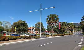
Mount Ousley is a residential suburb situated on the foothills of Mount Keira about four kilometres northwest from the city of Wollongong, New South Wales, Australia. It is also the name of the road which crosses the nearby Illawarra Escarpment and is adjacent to the University of Wollongong. Mount Ousley has a public school, Mount Ousley Public School.
| Mount Ousley Wollongong, New South Wales | |||||||||||||||
|---|---|---|---|---|---|---|---|---|---|---|---|---|---|---|---|
 | |||||||||||||||
 Mount Ousley | |||||||||||||||
| Coordinates | 34°24′S 150°52′E | ||||||||||||||
| Population | 1,602 (2016 census)[1] | ||||||||||||||
| Postcode(s) | 2519 | ||||||||||||||
| LGA(s) | City of Wollongong | ||||||||||||||
| State electorate(s) | Keira | ||||||||||||||
| Federal division(s) | Cunningham | ||||||||||||||
| |||||||||||||||
References
- Australian Bureau of Statistics (27 June 2017). "Mount Ousley (State Suburb)". 2016 Census QuickStats. Retrieved 16 July 2017.
Текст в блоке "Читать" взят с сайта "Википедия" и доступен по лицензии Creative Commons Attribution-ShareAlike; в отдельных случаях могут действовать дополнительные условия.
Другой контент может иметь иную лицензию. Перед использованием материалов сайта WikiSort.org внимательно изучите правила лицензирования конкретных элементов наполнения сайта.
Другой контент может иметь иную лицензию. Перед использованием материалов сайта WikiSort.org внимательно изучите правила лицензирования конкретных элементов наполнения сайта.
2019-2025
WikiSort.org - проект по пересортировке и дополнению контента Википедии
WikiSort.org - проект по пересортировке и дополнению контента Википедии